This boarded-up tunnel in the mountains of southwestern Pennsylvania dates back two centuries. It was originally built by Carnegie and Vanderbilt for
The post Tunnel 51 appeared first on Sometimes Interesting.
This boarded-up tunnel in the mountains of southwestern Pennsylvania dates back two centuries. It was originally built by Carnegie and Vanderbilt for
The post Tunnel 51 appeared first on Sometimes Interesting.
Built in 1901, the Inn at Buck Hill Falls was once the class of Poconos Mountain resorts. The thousand-acre retreat featured amenities
The post Abandoned Poconos Legend: Buck Hill Inn appeared first on Sometimes Interesting.

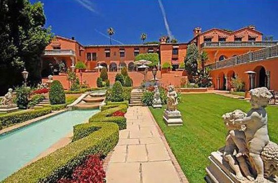
This house in Middle America fits the definition of excess (unless you consider having a bowling alley and an eight-car garage necessary). It’s builder’s use of the finest materials rang up an eventual construction bill of $27 million – in a neighborhood with a median home price of $234,600.
What makes this home stand out isn’t the forty-thousand square feet, hidden rooms, or any of its many spiral staircases. More interesting is the story of who built the home, and how construction was funded.
*
The home was the creation of Darain Atkinson, an entrepreneur with a crooked moral compass. Together with his younger brother Cory, the brothers launched down a path of three separate endeavors toward auto warranty fraud dating back to July of 2001.
That year Darain and Cory Atkinson (pictured below) founded Big Time Productions, Inc., their first collaboration in this venture.
[caption id="attachment_13834" align="alignleft" width="263"] Darain & Cory Atkinson[/caption]
By February of 2003 the brothers decided to re-launch the company under the name “National Auto Warranty Services Inc.,” and for the next five years they made millions while observing explosive growth via deceptive business practices.
In 2006 Cory reported no taxable income despite receiving distributions totaling more than $14 million.
After one too many misleading sales pitches, the attorney general got involved. And in 2008 the mistreatment of customers was significant enough to drive the formation of what would become the Vehicle Protection Association (VPA).
The public caught on, and sentiment became increasingly negative. To avoid the poor publicity, the brothers decided to change the name once more.
*
 “Fidelis” is Latin for faithful, loyal, or trustworthy. It was likely no accident that brothers Darain and Corey Atkinson chose this word when re-launching their auto warranty business in early 2009.
The name change to "US Fidelis" didn’t fool everybody, and by April of 2009 there were over 33,000 inquiries and about 1,100 complaints filed with the Better Business Bureau. Also not fooled were the now forty attorney generals investigating the Atkinsons, who would eventually succeed in shutting the brothers down.
![]() above: US Fidelis logo.
above: US Fidelis logo.
below: old Fidelis online advertisement (Not a real ad)
[caption id="attachment_13838" align="aligncenter" width="400"] Sample US Fidelis Internet advertisement[/caption]
*
But not before US Fidelis would eventually grow to become one of the largest auto warranty companies in the United States. The company did not stop writing new business until December 29th, 2009; three months later the company filed for bankruptcy.
At the time US Fidelis listed assets of $74.4 million and liabilities of $25.8 million, according to the bankruptcy filing. Afterward Darain and Cory were accused of funneling $100 million of US Fidelis funds to pay for their cars, jewelry, and estates.
Restitution would be partially serviced immediately by the relinquishment of the brothers’ properties, including Darain’s enormous lakefront home in Lake St. Louis.
*
[caption id="attachment_13805" align="aligncenter" width="550"] courtesy Emily Rasinski[/caption]
 As it turns out unprecedented levels of fraud can buy stratospheric opulence, levels of which most middle class can’t even fathom. The house was built for a staggering $27 million in 2007, at the top of the real estate market cycle.
According to county tax records, the home Darain built at 5 Lakeview Court is 20,752 square feet (although some real estate listings indicated 32,767 and 40,000 square feet) and has nine bedrooms, twelve bathrooms, and four half-baths.
The home occupies 6.7 acres of prime real estate along Lake St. Louis, and when including the den, kitchen, living room, and study, the manor boasts a total of 24 rooms.
[caption id="attachment_13818" align="aligncenter" width="550"] courtesy William C. Hutton, Jr.[/caption]
| Legal Description LSL #249 LOT 1 | |
| Lot Size 6.7000 AC | |
| Year Built: 2007 | Property Type: SINGLE FAMILY RESIDENCE |
| Bedrooms: 9 | Base Area: 15,435 |
| Bathrooms: 12 | Total Area: 20,752 |
| Half Bathrooms: 4 | Total Rooms: 24 |
 The economics are mind boggling. With the home’s 20,752 square feet and an estimated build cost of at least $26.7 million, the resulting math indicates Atkinson paid upwards of $1,286 per square foot for such magnificence.
Compared to his neighborhood’s 2007 median of about $120 per square foot, the former fraudster paid a staggering ten times more for his lakefront mansion.
What does this kind of outlay get a buyer? The largest home in St. Charles County, for starters. Here is a partial feature list:
*
[caption id="attachment_13845" align="alignleft" width="136"] courtesy Emily Rasinski[/caption]
The kids rooms had miniature porcelain toilets installed. Fanciful spiral staircases abound, including one which leads to a steeple that overlooks Lake St. Louis (at left).
This is not the only place in the home with views; at the back of one of the master bedroom walk-in closets is a hidden passageway (below right) which leads to a sitting area, also with sweeping views of Lake St. Louis.
If residents get tired of the spiral staircases, the house has an elevator. In the office and study, the floors were made of leather.
 The house seemed to have everything, but it was only 90% finished by the time Atkinson’s world started collapsing and US Fidelis filed for bankruptcy.
At the time the company had at least 331 payments totaling over $7.2 million toward building expenses of Darain’s estate.
Contractors hadn’t been paid either; approximately $1.7 million across 20 mechanic’s liens were placed on the property as well.
[caption id="attachment_13813" align="aligncenter" width="550"] courtesy William C. Hutton, Jr.[/caption]
*
 Darain Atkinson’s assets were eventually turned over to creditors after the bankruptcy settlement for US Fidelis.
The list of assets collected was long, lawyers referred to the Lake St. Louis estate as “the big house” to differentiate it from Atkinson’s other multiple luxury homes, boats, cars, and other toys. (The bankruptcy estate received a $2.45 million offer to buy Cory Atkinson's vacation house in Truckee, Calif., near Lake Tahoe, and a $675,000 offer on Darain Atkinson's Lake Saint Louis house.)
[caption id="attachment_13812" align="alignleft" width="205"] courtesy William C. Hutton, Jr.[/caption]
An exception by the bankruptcy settlement was established for each of the co-conspirators' wives, who were allowed to keep $500,000 plus $75,000 in jewelry and household items.
In April of 2010 the US Fidelis co-founder listed his Lake St. Louis mansion for sale, asking half the estimated cost to build just four years prior: $14.9 million.
Realtor descriptions are usually an entertaining read, and the Atkinson mansion was no exception. From the (now dead link) Sotheby’s property listing details:

“This European inspired mansion has an array of handpicked, imported materials and unique finishes from exquisite walnut and marble to spectacular molding details and natural finishes throughout.
It features a music room, turret room, movie theater, indoor bowling alley, 8,000 Sq. Ft. outdoor entertaining area, safe room, second living quarters, study, billiard room, art studio, spa-retreat, playroom, exercise room, eight car garage, and porte cochere. Majestic floor plan of 40,000 square feet for living and entertaining in the grand style of the Newport cottages.”
By November of 2010 the high bid was $4.75 million for the mansion, and it came from the recently-formed Lakeview Acquisition Group, LLC. In December it was reported the buyer was anonymous and an agent representing the buyer told reporters the house was not finished, needing an estimated $3 million to complete the indoor basketball court and pool. To offset this, the home’ purchase price included two boats, five mopeds, and a tractor. It was later learned the buyer was a local NFL agent with a roster of about 35 NFL player clients.
 According to the agent for the buyer, it was an all-cash deal. "Nobody wanted to lend more than $4 million because of the location."
[ In July of 2011 brother Cory Atkinson’s mansion, which had a children’s jungle gym larger than most people’s homes and cost $10 million to build, received a $2.8 million offer from a Boeing executive. ]
The following month the buyer would turn around and sue the bankruptcy estate for items missing from the sale including “a fountain, dining room furniture, and some household appliances and electronics.”
Also allegedly missing: “at least 24 audio speakers and a machine that regulates salt water in the mansion's swimming pool.” The lawyers representing the bankruptcy estate called it a frivolous lawsuit and threatened sanctions.
[caption id="attachment_13836" align="aligncenter" width="550"] courtesy Emily Rasinski[/caption]
*
 The Atkinson brothers owed millions in back federal and state income taxes, dating to 2006 when Darain received more than $13 million in distributions. In 2007 the brothers both pocketed $8 million, and the following year the US Fidelis enterprise paid them more than $13 million each.
In September of 2012 US Fidelis co-founder Corey Atkinson (himself already a convicted felon from a 1987 conviction) was sentenced to 40 months in prison and ordered to pay $4 million in restitution to the IRS.
Older brother Darain Atkinson (also already a convicted felon from a 1986 conviction) was sentenced to eight years in prison and also ordered to pay $4 million in restitution.
[caption id="attachment_13835" align="aligncenter" width="550"] photo courtesy David Carson[/caption]
*
[gallery type="rectangular" td_gallery_title_input="Additional Photos" ids="13863,13853,13854,13855,13856,13857,13858,13859,13860,13861,13864,13865,13866,13867,13868,13852,13862,13814,13815,13820,13809"]
Photos courtesy Emily Rasinski
*
Watch: A local news story from 2010 takes viewers on a tour of the Atkinson mansion:
[youtube="https://www.youtube.com/watch?v=cS_VrLz5kb0"]
• Which house is the biggest in the United States? One home fighting for the title is Versailles in Windermere, Florida. Map it!
• NASCAR driver Rusty Wallace once had US Fidelis as a title sponsor. It did not go over well with fans.
 ***
***
The post Spoils of US Fidelis appeared first on Sometimes Interesting.
words & photos by Cary O'Dell
It would probably look a little out of place in just about any neighborhood, let alone sitting on a grassy corner lot in the Midwestern college town of Carbondale, Illinois.
This dome home--looking for all the world like a half-buried golf ball jutting up from the soil-- certainly does stand out, surrounded as it is by far more traditional box-shaped one- and two-story houses. But it is more than just an incongruent eye-catcher in this otherwise typical neighborhood. It is a bit of Americana and a bit of history, architectural and otherwise.
*
 From 1960 to 1971, it was the home of Buckminster Fuller (pictured), and is the only dome that Fuller himself ever lived in. Interestingly, it also represents the only property that Fuller ever owned.
Fuller, of course, had been promoting geodesic dome construction, along with many other architectural and design innovations, for many years.
Born in 1895, Fuller would, along with patenting the geodesic dome, also coin the term “Spaceship Earth,” author over 30 books, and manifested various breakthroughs in cartography, transportation, and other feats of engineering.
 Beginning in 1960, Buckminster (called “Bucky” by his friends) and his wife Anne began residing in Carbondale, Illinois, where Fuller taught classes in design at Southern Illinois University of Carbondale (SIUC).
Of course, once the couple arrived in southern Illinois, they needed a place to live. So, at 407 South Forest Avenue (map), Bucky built his dome home.
[gallery type="columns" link="file" columns="2" size="medium" td_gallery_title_input="Dome Home Construction" ids="15016,14991"]
Though most homes require months of construction before they become inhabitable, the dome was erected, on site, by the Parrish Construction Company, in only seven hours.
The installation took place on April 19, 1960. Fuller, and many of his students, were on site throughout the day’s build.
[caption id="attachment_15005" align="aligncenter" width="550"] Buckminster Fuller Dome Home blueprint reproduction drawn by Thad Heckman.[/caption]
*

 [ Buckminster "Bucky" Fuller was an architect, author, designer, educator, engineer, entrepreneur, futurist, inventor, mathematician, and philosopher (click here to read Buckminster Fuller quotes). Among his more well-known creations were the Dymaxion Car (pictured above right) and the Dymaxion House. ]
*
[caption id="attachment_15017" align="alignright" width="300"] Dome Home circa 1960 (courtesy Atlas Obscura)[/caption]
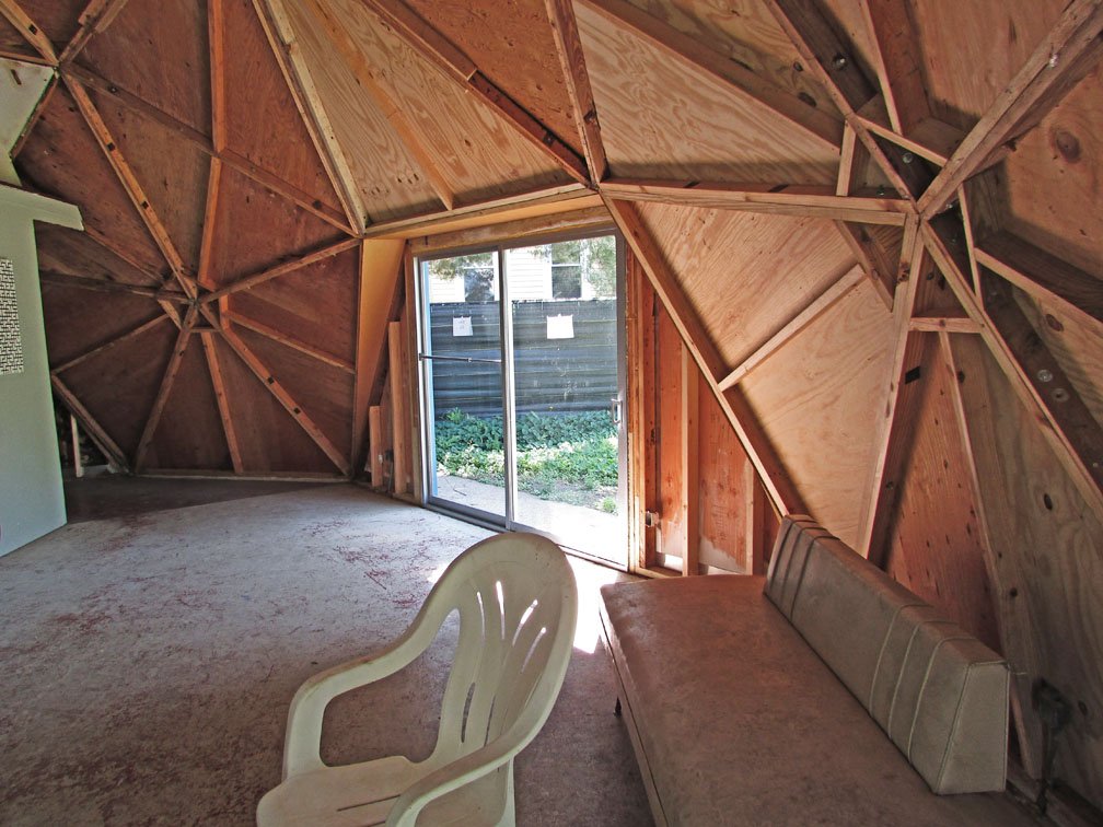
Affectionately known among the locals as the “Bucky Dome,” the dome home spans 39 feet and one inch wide (or across) and rises 16 feet, 6 inches high. Originally, the home was colored blue and white.
A fan of sailing, it is speculated that Bucky’s original color choice for the house was meant to suggest a sail boat on the ocean.
In keeping with the basic geodesic design, the roof of the home is a series of triangles, interlocked and forming a dome.
The structure has only five vertical surfaces--a series of plywood panels arranged around each of the home’s “sides” which each holds either a patio screen door (which grants the house a variety of entrances as well as loads of natural light) or two rectangle window panes, one above the other.
[caption id="attachment_14989" align="aligncenter" width="450"] Bucky Fuller's Geodesic Dome Home[/caption]
Of course, in a circular home there could be much debate about what constitutes the “front” door but on this dome home’s most east-facing portion is a single-sided entrance that is usually acknowledged as the “main” entryway.
A rather vintage and common-looking aluminum screen door (the only “swinging” exterior door in the house) also designates it as such.
*
 Once inside the very small foyer, the visitor is immediately faced with a directional choice of left, right or forward.
Choosing left takes you into the home’s main living space, its living room which constitutes about half of the home’s circle. The large patio doors as well as the structures overhead (recently restored) skylights make the space quite well-lit.
Despite the relative smallness of the house—it’s just a one-bedroom home--there is nothing cramped about it. In fact, thanks to the high ceilings and the “open” floor plan of the entire space, the house actually feels quite spacious.
More or less at the center point of home is a staircase. It is the entry to Bucky’s second floor study, a highlight of which is the specially-built curved bookcase that runs along the home’s back wall.
[gallery td_gallery_title_input="Fuller Bookcase: Then & Now" link="file" ids="14987,14978,14984"]
photos courtesy Cary O'Dell
The upstairs study not only maximizes the dome’s upper space but creates a hidden space underneath it to contain, behind sliding wood closet doors accessible from the first floor, all of the home’s necessary machinery (its boiler, water heater, etc.).
Back on the house’s main floor, the living room flows seamlessly into the dining room and around to the kitchen.
While the kitchen’s single wall of sink, wood cabinets and major appliances look quite retro (if in a cool and hipster kind of way), the Fuller’s choice of an Eames table and chairs (visible in vintage photos) continues the home’s overwhelming modernist vibe.
[caption id="attachment_14983" align="aligncenter" width="550"] Bucky Fuller's kitchen (courtesy Cary O'Dell)[/caption]
Further around the circumference of the home, through a hanging door that folds accordion-like into the wall (another Fuller trait), one enters into the home’s bedroom.
It contains two serviceable, if very unromantic, single beds. At the back of the bedroom, between the two beds, is access to the home’s master bathroom. There is also within that room a small closet.
Exiting the bedroom, at the opposite end from where one enters, takes one through a (very small) vestibule/storage area where build-in shelves (try to) make the most of this existing space.
[gallery type="rectangular" link="file" size="medium" td_gallery_title_input="Bucky Fuller's Geodesic Dome Home" ids="14976,14977,14980,14974,14981,14982,14985"]
photos courtesy Cary O'Dell
Then, following the home’s normal, circular flow, one arrives back to the entry hall, back to where they started. There is also a door located there that leads into the home’s second bath, a guest/half bathroom.
A unique feature that Fuller drew into the original house also allows this second bath to be accessible from the bedroom which originally granted him and Anne his and her water closets.
[ Want more Dome Home content? Florida's Dome Home of Cape Romano currently sits in the ocean. ]
[gallery type="rectangular" td_gallery_title_input="R. Buckminster Fuller" link="file" size="medium" ids="14966,14967,14968,14969,14970"]
above images courtesy Deutsche Bank collection
*
Though one assumes that living in such a minimalist setting could be aggravating from time to time, there remains something exceedingly calming, even aggressively Asian, about the “life in the round” that this home suggests.
 Fuller’s teaching agreement with SIUC called for him to teach on-site for only two months a year. The remainder of his time was spent on far-reaching travels and a very busy worldwide lecturing schedule. Hence, there is some debate about how much actual time, how many actual nights, Fuller actually spent living and sleeping in the dome home.
But his wife, Anne, usually remained behind and, therefore, in the residence. An oft-reprinted photo of Anne carrying in bags of groceries from her car into the house shows that, to her at least, this house was just home.
 [ Did you know? Bucky Fuller patented the dome home in 1954 as "a solution to humanity's need for safe, affordable and accessible housing." ]
Not every part of dome living however was easy. Ceiling water leaks were common within the dome. Eventually, the Fullers had old-fashioned brown shingles installed on top of the dome. The covered roof may have lessened the visual impact of the home but it did alleviate the leakage—at least for a time.
The Fullers moved out of the dome in 1971 when Bucky accepted a teaching position elsewhere. Fuller died in 1983. Anne died only hours after her husband.
As for the dome home, for the next 30 years the home was rented out, mainly to students who were coming to study at SIUC. Almost every year, throughout the 1980s, in the “For Rent” classified section of the local newspaper, one could find listings like this sample:
[caption id="attachment_15002" align="alignleft" width="300"] Bucky Fuller & Anne Hewlett Fuller relax inside of a dome home, circa 1966 (courtesy Buckminster Fuller Institute)[/caption]
CARBONDALE. Buckminster Fuller’s Geodesic Dome, very private. Enclosed by high redwood fence. 2 Bedrooms & 2 baths. 932-3411.
*
 Finally, in 2001, Bill Perk, a now retired SIUC professor, purchased the home and donated it to a specially-formed non-profit that was organized with the specific mission to restore the dome it to its original “Bucky” era state.
Today, Jon Davey, an architect and an instructor at SIUC, heads up the group RBF Dome NFP; Thad Heckman, also an architect and instructor the SIUC prepared the Preservation Documents for the Dome in conjunction with the National Park Service and the Illinois Historical Preservation Agency.
The preservation has not been an easy undertaking. Numerous issues, some of them unique to a dome dwelling and some of them simply the norm for any 54-year old structure, have plagued the efforts.
Furthermore, in order to bring the dome back to how it was in Bucky’s day, the group has to undo many latter-day (and often ill-advised) “enhancements” and repairs.
[caption id="attachment_14994" align="aligncenter" width="550"] Bucky Fuller's geodesic dome home with protective cover (courtesy Google streetview)[/caption]
Around 2002 or ’03, after the home moved into the hands of the NFP, and prior to plans being drawn up and money raised for its rehabilitation, a second dome, this one made of steel, was constructed and placed over the entire existing original home in order to protect the original structure from the elements and enable workers to conduct work on the exterior of the home.
This fabric-covered secondary shield (pictured above) has only recently been removed.
[caption id="attachment_15007" align="alignleft" width="300"] Fuller's geodesic dome for the U.S. pavilion at EXPO '67 in Montreal[/caption]
With this temporary safe-guard in place, the group could not take on its first task: assessing the basic structure of the home. Over time, some of the dome structure had become “sprung,” bowed by the elements and a history of poor repairs.
For a number of years, a wood pillar had to be installed inside to brace the dome’s internal frame. Thankfully, with the exterior preservation work now completed, this problem has since been resolved.
Over the years, many production companies, architectural firms and even DIY-type TV shows have offered to take on the Bucky Dome project. Unfortunately, these outside entities often have an eye more for a speedy rehab than for historical accuracy. Hence, progress has, at times, been slow.
[caption id="attachment_14964" align="alignright" width="190"] Remains of Fuller’s geodesic dome of the Expo '67 pavilion circa 1984 (courtesy Robert Duchesnay).[/caption]
Today, though, after a decade of toil, fundraising and planning, Phase One of the restoration has been lovingly completed and the exterior of the Bucky Dome now matches what it originally looked like.
The home’s roof has also been carefully “upgraded” to withstand the cold Illinois winters and, unlike in Bucky’s day, not drip internally.
As the exterior of the home has now been returned to its original state, the NFP is now free to concentrate on its next phase, the restoration of its interiors. Team members hope not only to repaint the walls and the like their original color, etc., but also to repair, replace or replicate as many of the original furniture and furnishings as well.
In keeping with the home’s basic aesthetic, the original Bucky-era interior was minimal and eclectic, much of it decorated with items gifted to Buckminster Fuller during some of his world travels.
Most of these items have long ago been lost or sold but the team is determined to find (or build) replacements as close to the originals as possible. Via modern photographic techniques, the team even hopes to zoom in on some of the titles on Bucky’s upstairs bookshelf and refill that space with copies of these titles.
[caption id="attachment_14979" align="alignleft" width="225"] courtesy Cary O'Dell[/caption]
Some refurbishing will take a little guesswork and a little faith. For example, the large wall-mounted mirrors affixed above the tub in the bathroom might have been added by a later tenant of the home. But since there’s no way to prove they weren’t installed under the Fuller’s tenure, the mirrors will remain in place until it’s proven otherwise.
The group hopes that the concurrently running Phase Two and Phase Three (Three will focus on the concrete, sidewalk, privacy fence and landscaping around the home) will be completed within the next two to three years.
Once the restoration if finished, it is also the hope of the RBF Dome NFP to turn the home into a museum and center for study by Fuller scholars. A newly-created group, Friends of the Dome, has been christened in order to provide and raise money for the home’s annual upcoming, estimated at about $8,000 a year.
In 2003, the home was recognized by the city of Carbondale as a historic landmark. In 2006, it was added to the National Register of Historic Places.
[caption id="attachment_14973" align="aligncenter" width="550"] Exterior of Bucky Fuller's geodesic dome home has been recently restored (courtesy Cary O'Dell)[/caption]
please visit fullerdomehome.org for additional information
***
The post Buckminster Fuller’s Home in a Dome appeared first on Sometimes Interesting.

Looking for some serious inspiration for your new house design? Or are you looking to sell house fast and upgrade your property? Sit back and take in the beauty and awe that the five most amazing property designs in the world have to offer.
From Mumbai to Florida to Portugal, prepare to be blown away by some absolutely amazing properties.
*
This 27-storey skyscraper in downtown Mumbai is the first billion dollar home…in the world! The largest and most expensive home in the world was built by Mukesh Ambani, petrochemical billionaire and the 5th richest man in the world.
The home features a health club with a gym and dance studio, at least one swimming pool, a ballroom, guestrooms, 9 elevators, a variety of lounges and even a 50-seater cinema. The tower also has not one but three helipads on the roof, and a parking garage on the lower floors with capacity for 160 cars.

*
Our list now takes us from the most expensive home in the world to the largest family home in the U.S., Versailles in Florida. Built by property tycoon David Siegel, the 90,000 square foot property is located about 20 miles from Orlando and boasts amazing views of Lake Butler.
The full construction of the property will not be completed until 2016 however on completion, it is expected to go to market at over $100 million, making it the 4th most expensive home in the U.S. The mansion will boast 30 bedrooms, 23 bathrooms, a bowling alley, roller skating rink and an Olympic sized swimming pool.
*
Casa Fez is a property which tops many people’s dream homes list. Built by architect Alvaro Leite Siza Vieira, son of world renowned architect Alvaro Siza Vieira, this property almost resembles a gallery or museum. Its simplistic design of a white structure built on a non-descript site with natural light, wooden floors, bold ceilings and unornamented windows is the perfect combination and proves a stunning visual treat.
*
Finished in 2008, this property was built to serve as the residence for one of Malaysia’s power families.
This stunning 3,000 square meter residence includes nine bedrooms, two family rooms, a family kitchen and a private dining area, a family library, a game room, a study, a public reception area, a formal dining room, a ballroom, chapel, 21 bathrooms, a swimming pool, two guest suites plus indoor private and guest parking.
 *
*
Known as “The Godfather mansion”, Hearst Mansion boasts an asking price of $135m, making it one of the most expensive residential properties the US.
It is the former home of U.S. newspaper tycoon William Randolph Hearst. The stunning property boasts 29 bedrooms, three swimming pools, tennis courts, its own cinema and even an on site nightclub.
**
The post Five of the Most Amazing Property Designs Across the World appeared first on Sometimes Interesting.

[caption id="attachment_15255" align="aligncenter" width="550"] Emerson School, Oklahoma City, OK[/caption]
The Emerson School dates to 1895 and is one of the first public schools built in Oklahoma City, Oklahoma. The classic building is already rich in history, but a recent discovery of some hidden chalkboards offers a rare view into the classrooms of one hundred years ago.
*

 The project began innocently enough as a summer renovation to the school as part of the MAPS for Kids program, a $700 million refresh intended to modernize and upgrade the city’s public school system. Part of this renovation called for the replacement of the old green chalkboards hanging in four of the classrooms in the 120 year-old school. To be installed were new interactive whiteboards (aka “Smart Boards”), which allow for user input by touch.
When the contractors removed the chalkboards, they discovered something incredibly rare: Unmolested blackboards containing the writings of students and teachers from 1917. Said renovation project manager David Todd: “We usually find broken pipes and wires... so this is a pleasant surprise.”
[gallery type="rectangular" link="file" td_select_gallery_slide="slide" size="medium" ids="15222,15223,15224,15225,15229,15230,15231,15234,15237,15227,15232,15238"]
photos courtesy Oklahoma City Public School District & NewsOk.com
Nearly one hundred years ago, these slate black boards were replaced at Emerson by D. J. Gers & Company over an extended Thanksgiving break in 1917. To commemorate the event, the boards were dedicated on November 30th and December 4th of 1917.
 The students who stood at the blackboard finishing the day’s lessons might have been unaware they were etching script which would stay buried for nearly a century, lest the boards be filled with more personal notes and signatures.
The teachers likely knew there might be an opportunity to preserve the day’s lesson in time, evidenced by their collective failure to clean the blackboards after class that day. The school's janitor, R.J. Scott, most certainly knew as he was keen to leave a note for whomever was fortunate to discover the buried history years later.
“We this day give to this room slate blackboards."
– R.J. Scott, Emerson Janitor in 1917
[caption id="attachment_15252" align="aligncenter" width="550"] courtesy NewsOk.com[/caption]
Findings at this urban archaeology site weren’t limited to the blackboards; newspaper clippings and old report cards were also found stuffed inside the walls.
“Women’s shoes, $3.00!” exclaims one very dated advertisement.
*
Compared to the text, the illustrations on the hidden chalkboards are elaborate and exact, suggesting they might be the work of a patient teacher’s hand. A pledge on one of the blackboards speaks to a time in which religion played a greater role in the classroom: “I give my head, my heart, and my life to my God, and one nation, indivisible, with justice for all.”

Student names such as Agnes, Gladys, Homer, and Mable are neatly written on the boards, although their significance is not known. Class leaders or hellions? Civics and cursive lessons are visible, as are notes on personal hygiene.
 Coincidentally, the word “whoa” is also seen written on the blackboard, although it is likely in reference to the horse command and not an exclamation of awe.
On one blackboard a calendar shows an abandoned transition from November to December in 1917. On another board some notes follow a treble clef, indicating a curriculum that included music. Of interest to the school’s teachers was the fact each of the four classrooms contained illustrations of pilgrims and corresponding lessons about Thanksgiving. To them this suggested a potential cross-curriculum teaching style in 1917.
The multiplication wheel is perhaps the most striking evidence of teaching methods in generations past. When discovered, nobody at Emerson could understand just how it works (this post provides a detailed explanation).
[caption id="attachment_15244" align="alignleft" width="240"] Emerson principal Sherry Kishore[/caption]
School principal Sherry Kishore was fascinated of this find. “I have never seen that technique in my life.”
Kishore acknowledges not just the rarity of the find, but the quality as well. “The penmanship blows me away, because you don’t see a lot of that anymore. Some of the handwriting in some of these rooms is beautiful.”
To Kishore, the cursive handwriting stands out on the hidden chalkboards most. “We have kids that come that prefer to print because they don’t know how to do cursive.”
[caption id="attachment_15226" align="aligncenter" width="550"] Emerson school multiplication table (illustration circa 1917, photo circa 2015)[/caption]
*
To its credit, the Oklahoma City Public School District has worked to preserve the previously hidden chalkboards. In an era when education budgets have been slashed and resources spread thin, it is not uncommon to see surplus education materials demolished or discarded. A preservation effort is both respectable and worth noting.
[caption id="attachment_15246" align="aligncenter" width="550"] courtesy NewsOk.com[/caption]
Protecting such a find is not easy. Chalk is not a permanent medium; a brush of the finger can wipe away the discovery. Even if protected, anything short of complete darkness could accelerate the deterioration of the bright colors and text.
To battle this, Oklahoma Historical Society representative Jeff Briley suggested protecting the formerly hidden chalkboards with acrylic glass, then controlling the light and temperature exposure. He figures with proper care and environment the blackboards could last another one hundred years.
[gallery type="square" link="file" size="medium" ids="15248,15253,15243"]
“It was almost like a spiritual moment because people who had lived and played and worked in here, a part of them is preserved… It’s like you’re going back in time.”
- Sherry Kishore, principal
 City Public Schools superintendent Robert Neu affirms the blackboards will be preserved, regardless the cost. “It may mean we have to delay the start of school in these classrooms, but we’ve got to preserve these.”
Teacher Sherry Read believes there was purpose behind the teachers of 1917 leaving behind the lessons of the day on the hidden blackboards. “I think they left them there on purpose to send a message to us, to say, ‘This is what was going on in our time.’”
Next scheduled for renovation? The floors.
This time Emerson teachers are eagerly looking forward to the next time contractors come to tear up the school.

photos courtesy Oklahoma City Public School District
**
The post Oklahoma’s Hidden Chalkboards of Yesteryear appeared first on Sometimes Interesting.

It might be hard to believe the "Glass Bank" was once a visually stunning piece of architecture. Opened in 1962, the structure was entirely glass-walled before a 1980s renovation gave it a brutalist makeover. The building was penned by a famed local architect and served the city for more than four decades before hurricane damage forced the last commercial tenants to relocate in 2004.
Over the next ten years disagreements between owners prevented needed repairs, and the financial crisis prevented any bailout. Only one man stood in the way of the building's demolishment, but he couldn't fight forever. The Glass Bank’s fate was eventually decided by the courts in 2014, and by early 2015 more than fifty years of Cocoa Beach history was demolished.
cover photo courtesy Jason Perrone

*
[caption id="attachment_15035" align="alignright" width="149"] courtesy Rob Stephenson[/caption]
Cocoa Beach sits on a beautiful strip of sand along Florida’s east coast, splitting the difference between Jacksonville and Miami. It is mere miles from Patrick Air Force Base, NASA’s John F. Kennedy Space Center, and NASA’s Cape Canaveral – all of which heavily influenced the region and helped it earn the nickname “the Space Coast.”
In the 1960s the American Space Program was quickly transforming Cocoa Beach, and overall modernization bled into the city’s architecture.
One of the crown jewels of this metamorphosis was the First Federal Savings and Loan Association of Cocoa Beach.
Thirty-eight year-old architect Reginald Caywood Knight, a graduate of Harvard and veteran of M.I.T.’s department of architecture, was tasked with designing the building in 1960. Construction began that year and would continue throughout 1961.
[gallery type="rectangular" link="file" size="medium" td_gallery_title_input="Construction of the Glass Bank" ids="15044,15045,15046,15047"]
The grand opening was in April of 1962. First Federal Savings and Loan occupied the majority of the retail space at 505 North Orlando Avenue in Cocoa Beach, Florida, but over time residents would come to know the five-story structure with parabolic curves as the “Glass Bank.”
On the top floor was the Sky Room, a restaurant with 360-degree views of Cocoa Beach.
[caption id="attachment_15041" align="aligncenter" width="550"] The Glass Bank building, 1961 (photo courtesy Judy Hunt Davis Family)[/caption]
Guests could step outside to the wraparound “Skywalk” and watch space shuttle launches from nearby Cape Canaveral.
*
 It was a celebrated opening, however not all was flawless in the beginning. As beautiful as the Glass Bank was, its original design exposed one serious design flaw: The lack of easy and freight access to the upper levels.
With no direct elevator, customers and freight delivers to the Sky Room endured an unnecessarily onerous journey to the top floor. Perhaps this was a factor in the closing of the Sky Room in 1963, just a year after the Glass Bank opened.
 If the lack of direct access was a problem, it was remedied with the addition of the express elevator to the exterior of the building in 1963 (pictured at left).
This time restaurant and night club Ramon’s Rainbow Room would take over the top space, bringing food, music, and an atmosphere which proved popular in the era.
To its credit Ramon’s Rainbow Room became a legend in its own right, hosting astronauts, celebrities, and politicians on special occasions and often drawing crowds. It was known for its cocktails, jazz music, and good food.
 Ramon's Caesar Salad dressing was reportedly delicious and “unlike any other Caesar salad you’ve ever tasted; creamier, with a hint of sweetness and perhaps a bit of curry.” The dressing was famous, but the recipe was kept a closely guarded secret.
The Rainbow Room was founded by Don and Allene Holt, owners of the already-established Ramon’s Restaurant in town.
The original Ramon’s was a dark, ground-floor eatery that shared menus and astronaut-themed décor with the later Rainbow Room. But it lacked the more electric atmosphere provided by a glass penthouse.
With live music and 360-degree views of Cocoa Beach, the Rainbow Room was understandably a popular place.
(click to enlarge)
[gallery link="file" td_gallery_title_input="Ramon's Rainbow Room" type="rectangular" ids="15051,15048,15058,15057,15054,15049,15056,15052,15055"]
*
For seven years Ramon’s Rainbow Room entertained and fed its guests atop the Glass Bank, but as times change so do tastes.
By the late 1960s the penthouse lounge had already begun to fall out of favor. It closed in 1970, but was re-opened as “Marby’s Rainbow Room” later that year.
[caption id="attachment_15039" align="aligncenter" width="550"] Glass Bank before express elevator addition, circa early 1960s[/caption]
Marby’s Rainbow Room would not see its second anniversary; by 1972 the top-level restaurant would close for the final time. Meanwhile, First Federal Savings and Loan was still the primary tenant for the remainder of the building. Unbeknownst to those working inside, it too would soon become a former tenant.
 During the 1980s the Savings and Loan crisis unwound nearly a third of the thrifts in the country. Included in the speculative lending carnage was the death of First Federal in Cocoa Beach.
Twenty years into its existence, the Glass Bank lost its original tenant.
*
[caption id="attachment_15093" align="alignright" width="220"] Frank Wolfe[/caption]
Cocoa Beach resident and attorney Frank Wolfe wasn’t yet fifty years old when he purchased the rights to the penthouse space of the Glass Bank in the early 1980s.
Wolfe was an aggressive attorney who enjoyed an illustrious career spanning such positions as city attorney to chairman of the famous Ron John’s surf shop.
Wolfe transformed the look of the Glass Bank building with radical modifications that shifted the building from glass to stucco. Following the brutalist ethos, the building now appeared fortress-like, with concrete in place of glass. The penthouse restaurant was expanded to the perimeter of the building, removing the skywalk. Smaller rectangular portholes took the place of the former floor-to-ceiling windows.
In an irony of ironies, Wolfe had erected a two-story windowless penthouse on top of the Glass Bank.
The corners of the building were reinforced with concrete and covered in stucco. Gone was the floor-to-ceiling glass and wraparound viewing balcony for patrons on the top level. Ramon’s former express elevator now became a private elevator entrance for the new residence.

The Glass Bank had become a brutalist stucco monolith, although it continued to be known by the more flattering name. Local blogger Dan Reiter summarized one perspective on Frank Wolfe’s contributions to the Glass Bank:
“…her ill-fitting crown, the 1981 concrete penthouse addition, so willfully antagonistic of the intentions of Architect Knight––a windowless box, devoid of glass, off-kilter, a brutalist plug, blockading the cosmic flight of her skirt walls.”
Wolfe’s modifications were indeed a brutalist interpretation of Reginald Knight’s all-glass mid-century wonder. Whether or not Knight would have approved, we’ll never know. He passed away in 1973, (some say fortunately) before the building’s transfiguration.
[gallery type="square" link="file" size="medium" ids="15102,15095,15096"]
(click to enlarge)
For all the teeth-gnashing over the exterior modifications, few were privy to the wonders that lie within the structure's penthouse. To most it resembled rooftop HVAC equipment surrounded by an unattractive and unnecessarily large beauty wall.
In fact, the five-story building had been expanded into a seven-story building.
The public-at-large did not realize what Frank Wolfe was doing, but the attorney was happy to keep secrets. It would be nearly three decades before Frank would treat the public to an inside-look.
[caption id="attachment_15134" align="aligncenter" width="550"] Highlighted portion shows Wolfe penthouse addition[/caption]
*
 Frank Wolfe concocted a plan for his own private retreat, one in which he could escape the occasional unpleasant realities of the outside world. This concept is not dissimilar to that of a “man cave.” It's not just a place to hang out, it's a metaphorical security blanket, or a retreat for times of adversity or stress.
It just so happens Frank built his man cave atop a mid-century glass-walled landmark. But let us forget about the raison d'être for a moment; pictures will struggle, and words likely fail to do Frank's penthouse justice.
The Glass Bank's penthouse was what Tom Hank’s character in the 1980’s classic movie Big would have built if he were an executive for a toy company in Cocoa Beach instead of New York City.
Entry to the apartment is made via the exterior express elevator. Upon disembarking, visitors step into a nature-themed foyer sporting a small foot bridge with access to the arched entry to the penthouse (pictured below).
[caption id="attachment_15106" align="aligncenter" width="550"] Frank Wolfe leads through the Glass Bank penthouse foyer[/caption]
The sound of running water explains the foot bridge. It spans a small artificial stream fed by – what else – an extravagant indoor fountain on the right wall, doubling as a waterfall for the room’s 100 square-foot ecosystem.
Once across the foot bridge and inside the front door, the small foyer gives way to an enormous windowless two-story, several-thousand square-feet space. Rich wood paneling lines the walls and ceiling. Clean recessed can lights illuminate the main room from above.
Against the far wall, a faux-stone mountain is the room’s centerpiece. At its base, a giant fireplace added ambiance to gatherings and took the edge off coastal winter nights.
[caption id="attachment_15116" align="aligncenter" width="550"] Frank Wolfe poses in his living room for a rare public photo[/caption]
The edges of the indoor mountain reach to the far sides of either wall, each slope with its own forest illuminated by Christmas lights.
The absence of windows did not deter Wolfe from creating his own sky. More than a dozen faux clouds dot the walls on either side of the mountain.
*
[caption id="attachment_15108" align="alignright" width="240"] Penthouse bar & Christmas village[/caption]
Frank Wolfe preferred soft to hard edges. He appreciated lines which suggested a continuous flow or motion. Preferences for such amorphous shapes and waves were influenced by the ocean. Residing in Cocoa Beach offered one an intimate familiarity.
Almost everything had rounded lines. Cabinets, chairs, closets, entryway arches, sinks, tables, and tubs. A quick scan of the penthouse reveals a design language not difficult to decipher.
In the center of the room, a sunken group of exquisite leather couches encircle a round glass table. To the right of the couches, an arc lamp illuminates a six-place oval table in the dining area. On the other side of the room a curved bar with a padded and tufted treatment harkens back to the 70s (pictured above right). Adjacent to the bar, a Christmas village display stood erected year-round in a permanent in-wall diorama.
[caption id="attachment_15114" align="aligncenter" width="550"] Glass Bank penthouse office[/caption]
Frank’s circular office (pictured above) occupied another corner. Deep rich mahogany tones offset those of the brighter cedar in this rounded enclave. The walls were back-lit to effect a sense of, coincidentally enough, being in a rounded perimeter office. A large circle in the ceiling above housed fluorescent lights designed to mimic a skylight.
[caption id="attachment_15107" align="alignleft" width="240"] Kitchen of the Glass Bank penthouse[/caption]
The kitchen (pictured at left) stands in stark contrast to the rest of the apartment. Step inside to what looks like a cross between the kitchen of a luxury motor coach and the galley of a presidential submarine, but designed by the architects of the U.S.S. Enterprise.
Liberal use of cool fluorescent lighting gave the appearance of natural daylight. Laundry facilities were smartly built-in to the cabinetry on the right, efficiently hidden behind a curved closet next to the refrigerator.
Upstairs, a seating area claims the loft and overlooks the main living area below. The balcony is curved and weaves from one side of the wall to the edge of the stairs, which are also curved and lacked consecutive steps of equal width. A large swath of leather affixed to the ceiling looks like a cushioned bumper for a nearby alcove’s wavy molding. Crown molding varied from room to room but was fashioned from leather or a carpet-like fabric.
The master bed occupies another round space, sitting in its own circular enclave and topped with a unique padded leather ceiling (pictured below).
[caption id="attachment_15112" align="aligncenter" width="550"] Glass Bank penthouse master bedroom[/caption]
 The master bath was every bit as unique. A two-tone carpet cuts a soft path past the bathing area to the closet. On one side the shower and toilet sit in a carpeted alcove, the former separated from the latter by a set of elaborate window curtains.
And as any gentleman's private bath should have, Frank was sure to include his own urinal.
A Jacuzzi tub is the centerpiece of a rounded sunken enclave in the middle of the room, ringed by strip lighting – in a warmer color and offsetting the cooler daylight-hued lights from above (pictured below).
[caption id="attachment_15111" align="alignleft" width="240"] Master bathroom in penthouse of the Glass Bank[/caption]
The apartment’s mountain theme carries upstairs onto a giant oil on canvas which dominates the bathing alcove. It depicts a peaceful scene on the banks of a river underneath a mountain.
Aiding in the effect is a faux-stone wall, made of a synthetic foam and situated adjacent to the canvas, which rises from the backside of the tub and reaches to the ceiling.
Beyond the tub were the master closet space, with a large motorized rack in which Frank could push a button and spin his garments and shoes whilst picking out the day's ensemble. Given the narrow space of the closet, it must have been a shrewd facilitator.
(click thumbnails to enlarge)
[gallery link="file" columns="4" ids="15115,15113,15110,15109"]
[caption id="attachment_15202" align="aligncenter" width="500"] Your guess is as good as mine[/caption]
*
[caption id="attachment_15125" align="alignright" width="190"] courtesy bweissman[/caption]
In later years the Glass Bank’s concrete and stucco modifications were intended to be more functional – if less attractive – and better-equipped to deal with the high summer temperatures and occasionally rough weather.
Except hurricanes.
But few glass structures of this vintage could stand in the way of a motivated category four storm. The 2004 hurricane season was especially unkind to Florida, showing its east coast more major hurricanes than any year since 1964.
First it was category four Hurricane Charley in early August. Weeks later category four Hurricane Frances struck Florida and wrought a havoc which included the outbreak of more than 100 tornadoes across the Southeast. In September category three Hurricane Jeanne came through Florida to punish what Charley and Frances had uncovered, but left behind.
[gallery type="square" link="file" ids="15126,15124,15123"]
photos courtesy bweissman
Few buildings escaped the wrath of all three storms. The Glass Bank was no exception, although the penthouse, with its lack of windows, was spared.
Windows now broken and yielding to the elements, the building’s outer layer had been breached. Exposure introduced mold, mildew, and an accelerating rate of decay. If the environmental breach wasn’t enough of an uphill battle, the Glass Bank was afflicted with another issue common with buildings of this vintage: asbestos.
[caption id="attachment_15130" align="aligncenter" width="550"] Glass Bank's Super Scooper machine (courtesy bweissman)[/caption]
The final tenants of the Glass Bank building were Huntington Bank on the lower level, Nautilus Fitness on the mid-levels, and Frank Wolfe’s personal condominium in the penthouse.
All except for Wolfe left after the 2004 hurricane season.
[gallery type="slideshow" link="file" td_select_gallery_slide="slide" size="large" td_gallery_title_input="Glass Bank After Hurricanes" ids="15090,15089,15083,15084,15082,15079,15077,15073"]
photos courtesy michaelbrnd
*
[caption id="attachment_15132" align="alignright" width="190"] Glass Bank part-owner Joseph Yossifon[/caption]
Toward the end of its life the building was co-owned by the Glass Bank Condominium Association (GBCA) and Frank Wolfe; the former controlled all but the penthouse and wanted to restore the iconic building to its 1960s former glory. Frank was not interested in losing his penthouse.
GBCA representative Joseph Yossifon (pictured at right) did not see eye-to-eye with Frank Wolfe on fixes, remodel plans, or the overall direction of the building. Hurricane damage was extreme, but a lack of cooperation saw remodel plans evaporate.
Despite the hurricane damage, Wolfe’s penthouse still had electricity and running water. This only emboldened Frank to further entrench himself in his position. While no action was taken by the building's owners to fix the ailing structure, the city began to impose fines – at one point charging the Glass Bank owners $200 per day.
By January of 2013 the owners faced $161,600 in city code violations. Tack on other assessments, fees, and repairs to the building owed to Yossifon, and Wolfe’s tally had eclipsed one million dollars. Over the years Mr. Wolfe had also accumulated millions of dollars in assessments, fees, and repairs to Mr. Yossifon. The GBCA filed suit against Mr. Wolfe, who countered with a suit of his own against the GBCA.

“It’s just been like that for more than a decade, even when times were good nobody did anything with the building, so we’re tired of waiting and so as we promote Cocoa Beach… I just want to see the problem solved.”
- Mayor Dave Netterstrom
Yossifon was reluctant to yield to the city’s cries for demolishment, but ultimately agreed to a package deal that would waive the previously-assessed fines and liens.
In exchange for the building owners' agreement, the city agreed to front the money required for demolition, and allowed for it to be paid back over the next three years.
[caption id="attachment_15071" align="aligncenter" width="550"] courtesy michaelbrnd[/caption]
The community was divided on the fate of the Cocoa Beach landmark, but most could agree any action was better than the status quo. As the years dragged on, votes for preservation proved harder to find.
"It's absolutely wonderful. It brings back, for those who have been here, the space careers. It brings back a different time in America.”
– Phil Roberts, Cocoa Beach resident
[gallery type="square" columns="2" size="medium" link="file" ids="15072,15076"]
Frank Wolfe effects not retrieved (courtesy michaelbrnd)
*
[caption id="attachment_15080" align="alignleft" width="240"] courtesy michaelbrnd[/caption]
By September of 2013 the Glass Bank had accumulated city fines totaling $210,600. Convinced the fines were not going to achieve the desired results, city attorneys sought an injunction on a nuisance claim either forcing action by the owners or allowing the city to take control of the beleaguered property.
The city had the good graces of Yossifon and the GBCA, but Wolfe was steadfast in his stubbornness.
The city moved to ask the judge for authority to demolish.
For his part, Frank Wolfe had an easy solution for the city: Just buy the penthouse. He was not satisfied with the proposition of releasing his home in exchange to forgive debts which he believed to be fabricated and unjust. However municipalities aren’t in the habit of speculating in real estate, and Cocoa Beach wasn’t in a position to pay Frank’s market price.
[caption id="attachment_15078" align="aligncenter" width="550"] courtesy michaelbrnd[/caption]
"I just want it down. Everyone wants it down. I don't know anyone that's in favor of keeping it.”
– Rick Talbott, Cocoa Beach resident
[caption id="attachment_15197" align="alignright" width="240"] Stationery reads: Frank M. Wolfe, 505 North Orlando Avenue, Suite 304, P.O. Box 321299, Cocoa Beach, Florida 32932-1299, (407) 783-2218[/caption]
Frank’s world began to quickly unravel in the summer of 2013. The ailing Wolfe had temporarily returned to Maine to be with family; six months later, in January of 2014, the city moved forward with its grievance filing and submitted to the courts an agreement signed by the Glass Bank Condominium Association. In preparation for the demolition, the city shut off power and water to the penthouse.
The judge ultimately sided with the city and the GBCA. Wolfe, who was deteriorating and had recently returned to Florida from Maine, rejected the proposal and appealed the ruling. Weeks later, on February 4th, the court ruled in favor of the GBCA in a breach-of-contract lawsuit against Wolfe.
The very next day, on February 5th, 2014, the court approved the demolition order for the Glass Bank.
[gallery type="rectangular" link="file" size="medium" td_gallery_title_input="Penthouse Before Demolition" ids="15178,15179,15180,15181,15182,15183"]
photos courtesy Christopher Homer
“A lot of people were members of the Nautilus Club. We banked at Huntington Bank. It brings back memories for me, but I’m also glad to see it gone, no doubt.”
– Tony Hernandez, Cocoa Beach attorney
*
Frank Wolfe was dejected and weary. Years of legal battles had taken their toll on his health and wallet. With appeals and personal money exhausted, Frank had no more obstacles left to offer the impending demolition.
After the court decision Frank attempted to retrieve his effects from the building (diplomas, family photos, and other personal heirlooms). But when he pushed the elevator call button, nothing happened. He remembered the building’s power had been turned off – along with his access to the penthouse.
There was nothing left.
[gallery type="rectangular" link="file" size="medium" td_gallery_title_input="Locked-out Penthouse" ids="15129,15128,15127"]
photos courtesy bweissman
A friend of Frank’s later posted the following comment after a news article:
“…Frank told me that he was shut out from his penthouse atop the former Glass Bank because the electricity had been turned off for safety reasons, disabling the elevator. The city of Cocoa Beach had red tagged it and was refusing to allow him access to retrieve his personal property. He was leaving that night where he would make one last personal plea, this time to the city commission.”
[caption id="attachment_15075" align="aligncenter" width="550"] Left behind: Frank Wolfe's certificates & diplomas: 1) University of Oslo, Certificate of Completion: Summer Course July 6th – August 16th, 1957. 2) Rollins College, Bachelor of Arts June 6th, 1958. 3) Phi Delta Phi Fraternity, Initiation Certificate April 10th, 1959. 4) Omicron Delta Kappa Society, Membership Certificate May 7th, 1957.[/caption]
"It is very sad, but you have to accept change, and why would you want to live in an unsafe building?”
– Judy Wolff, Cocoa Beach resident
*
[caption id="attachment_15141" align="alignright" width="240"] courtesy spacecoastdaily.com[/caption]
If there was an appropriate end of the road for Frank Wolfe, it was in the penthouse of the Glass Bank building.
At approximately 3:06 p.m. on Wednesday, February 5th, 2014, the Cocoa Beach Police Department responded to a call of a body found in front of the building. A man was found dead from a self-inflicted gunshot wound.
Francis Marvin Wolfe was unable to make his spiritual return to the penthouse; the 82 year-old was discovered collapsed in the vestibule in front of the penthouse elevator access door. It was the closest he could get to his favorite place; the building's lack of power finally defeated him.
 Attorney Scott Widerman gave a statement on behalf of the GBCA:
"Our position is one of disbelief. We are naturally sorry to hear about this tragic event. It is not imaginable that this breach of contract action would have this result. The Trial and Appellate Court found Mr. Wolfe responsible for the damage to the building. This was not the outcome anyone could imagine or desired."
Nothing seemed amiss to longtime friend Bob Baugher. “I had a two hour meeting with him (Wolfe) this afternoon, and he seemed to be in good spirits.”
Wolfe was, however, declining in health. Reflecting, Baugher added Frank “dealt with things on his own terms.”
Count Baugher as one of Wolfe’s supporters; he feels the community failed Frank.
[gallery type="rectangular" link="file" ids="15173,15175,15177,15190"]
photos courtesy Christopher Homer
*
Frank M. Wolfe was born in Hartford, CT November 24, 1931. He completed his high school education in Hartford and enlisted in the Coast Guard serving three years in Korean Theater. He graduated from Rollins College, Winter Park, FL on June 6, 1958, with a degree in Bachelor of Arts, Business Administration and psychology. He then attended Stetson University College of Law, St. Petersburg, FL and earned his Juris Doctor degree on January 28, 1961. Before moving to Cocoa Beach he was Special Assistant to the Attorney General of the State of Florida. He was a senior partner in Wolfe, Kirschenbaum & Taylor, which later became Wolfe, Kirschenbaum, Caruso, Mosley and Kabboord, a major law firm in Cocoa Beach, FL. He also served as City Attorney from 1963 to 1967. During those years, he served on the board of several banks in addition to being one of the founders and directors of the Merritt Square Bank, Merritt Island, FL. From 1971 to 1981, he was CEO and Chairman of Leader International Inns, Inc., a large real estate company that owned and operated approximately 500 units in the Brevard County area. He was past Chairman of Ron Jon Surf Shop, headquartered in Cocoa Beach, FL, a large retailer known throughout the world. Mr. Wolfe was renowned for his architectural designing ability. He resided in the unique penthouse he built on top of the Glass Bank Building in Cocoa Beach, FL and he spent summer months in Maine where he designed and built a home on the Wells Reserve. He was generous to a fault and gave of himself to so many over the years, far too numerous to count. He was a loyal friend and advocate of the underdog. He demanded excellence of himself and his internal code of ethics was unshakable. He was loved by many. He left an impact on many lives and will not soon be forgotten. Died because he wanted to . . . Lived because he dared to.
*
 When Frank died, his estate elected to cooperate with the city. A deal was struck in April of 2014 which granted the city permission to demolish the iconic building.
According to the terms of the agreement, the Wolfe estate would be reimbursed for the property value when it was later sold. Similar to the deal with Yossifon and in exchange for allowing demolition, the Wolfe estate’s liens would also be resolved.
The bidding process for Cocoa Beach demolition projects typically sees at least 90 days, but the decades of pent-up motivation to raze the Glass Bank was immense. Within days of the agreement, city hall was collecting bids.

Most relieved of all parties appeared to be the city, its hands finally washed of the issue. But the agreement did little for the on-going dispute between GBCA trustee Yossifon and the estate of Frank Wolfe. City attorney Skip Fowler was succinct in his assessment:
“At least the city is out of it, and they can argue about who bought what from whom until the cows come home."
Cocoa Beach obtained eight bids for the demolition of the Glass Bank building. In September of 2014 the city selected Crusader Demolition of Lakeland, Florida, to handle the tear-down.
 But the Glass Bank wasn’t going down easy. As-if to do Frank proud, the building provided one last obstacle to delay the inevitable: On closer examination, Crusader Demolition discovered more asbestos than expected.
However the project stalled only momentarily; in the middle of December the city commissioners quickly approved spending an additional $32,320.
Just get it done.
December of 2014 was spent removing asbestos from the Glass Bank and salvaging the scrap materials. Demolition cost was adjusted to $177,000 and scheduled for completion in February of 2015. Cocoa Beach accommodated for the adjustment by placing an additional lien on the property (when the property eventually sells, the city gets reimbursed the amount “borrowed” before the seller receives the proceeds).
The empty lot should retain significant value: 82 feet of air rights will remain with the property, according to the demolition agreement.
[gallery type="slideshow" link="file" size="large" td_select_gallery_slide="slide" td_gallery_title_input="Glass Bank Demolition" ids="15169,15170,15171,15172"]
“It’s a shame to see it go but it’s not structurally sound and it’s an attraction for vagrants. It’s a public nuisance.”
– John Stroud, Cocoa Beach resident
Followers of the demolition story were temporarily distracted by a feral cat nicknamed Morris that had taken up residence in the abandoned building. After Morris was discovered it wasn’t long before a campaign was started to save the cat, which of course led to a dedicated Facebook page. His eventual capture prompted a news conference, and the feline former tenant even got his own day in Cocoa Beach.
[gallery link="file" ids="15185,15187,15186"]
Some residents made daily visits to the site during the demolition, memorializing via pictures and drone footage (watch below).
Spectators cheered when the last of the former Glass Bank came down on Groundhog day, 2015. If the public was feeling conflicted or reminiscent, it was buried in the rubble.
[youtube=“https://youtu.be/vjCFzilJlr8”]
"It has been a big part of Cocoa Beach's history. I can recall many, many years ago actually having dinner in the restaurant up there. It's just a piece of Cocoa Beach that, well it's kind of sad to see it go."
– Franklin Glass, Cocoa Beach resident.
*
[caption id="attachment_15174" align="alignleft" width="220"] courtesy Christopher Homer[/caption]
Most building damage was sustained in 2004, but the reality was the Glass Bank had already been decomposing for years.
Where did it all go wrong? Cocoa Beach author Dan Reiter offers the following:
“You might blame it on the space bust of the 60's, or the drug-riddled aftershocks of Nam, or the malaise and despair of the disco age. You might blame it on recessions, on layoffs, on depressed property prices, on the steady, gradual degradation of downtown, on hurricanes or lawyers or men possessed… The Glass Bank was the closest thing to a landmark of architecture that we have here in Cocoa Beach.”
You might also blame it on an inefficient floor plan, or an era when commercial architects could give function a backseat to form and corporate budgets were under less strict control. You might blame it on higher building maintenance costs, an older infrastructure, or point to the continuous threat of hurricanes.
Surely NASA's reduction of operations in 2011 had a heavy hand in the reduced fortunes of the local economy. Thousands lost their jobs as the Kennedy Space Center was mothballed.
Ironically, the largest obstacle just might have been the building’s ownership – or more specifically the parties’ inability to reach an accord.
[caption id="attachment_15176" align="aligncenter" width="550"] courtesy Christopher Homer[/caption]
*
 Fortunately a group of preservationists have worked to re-create a virtual Glass Bank building. Dr. Lori C. Walters is a Research Assistant Professor with the Institute for Simulation and Training and Department of History at the University of Central Florida, and leads a group pioneering the school’s Virtual Heritage program. Known as ChronoPoints, the group focuses on examining historic structures utilizing the latest digital technology.
3D laser scans are created to help develop accurate models of buildings in their heyday. After successfully recreating the 1960s New York World’s Fair (watch), the group turned their attention to the Glass Bank building.
Dr. Walters was allowed to scan the building prior to its demolition, which established dimensions and shape. But the goal was to re-create the Glass Bank in the 1960s, not the Stucco Bank of the 1980s – so vintage photographs have been requested to be scanned into the computer for rendering. (Have vintage photographs of the Glass Bank at its zenith? Contact Dr. Walters and let her know!)
In February of 2015 the group released a video which shows the progress to date.
[caption id="attachment_15192" align="aligncenter" width="550"] What the Glass Bank building might look like today had it been restored (courtesy Michael Rywalt)[/caption]
"Certainly the year you were first exposed to the building plays a role in how you feel about it."
-Dr. Lori Walters, Institute for Simulation and Training and Department of History at the University of Central Florida.
[caption id="attachment_15188" align="aligncenter" width="550"] Glass Bank demolition wrapping up[/caption]
*
*
This group of urban explorers takes us on a tour through the building before it was demolished:
[youtube="https://www.youtube.com/watch?v=OKMGUYP_jbc"]
[caption id="attachment_15194" align="aligncenter" width="550"] photo courtesy Jason Perrone[/caption]
*
As of the date of this post, the Glass Bank is still visible on Bing Maps in bird's eye view:
 ***
***
The post The Glass Bank appeared first on Sometimes Interesting.

The Canary Islands are well-known for their warm weather and water sports. Largest and most populous of the islands is Tenerife, which offers hiking trails, historic villages, local pubs, sandy beaches, water slides, and a national park featuring one of the world’s largest volcanoes.
Yet what you won’t find on tourism flyers is one of the more interesting places to see. On the Southeast coast of Tenerife, just up the hill from a newer small village, the remains of an aborted early twentieth-century sanatorium still bask in the bright sun.
cover photo courtesy Tenerife.panoshot.com
*
During the Spanish Civil War (1936-1939) an outbreak of leprosy on the island of Tenerife began to raise alarm; by 1940 a total of 197 cases had been reported. Early medicine lacked a familiarity with the infectious disease, and this was reflected in crude methods of therapy and treatment of the afflicted.
 At the time it was believed quarantined isolation in an arid, temperate climate was the most appropriate solution to dealing with the malady. Tenerife’s first leprosy station was on the north side of the island. The second would be located in Arico, near “Los Abriguitos” and present-day Abades (map).
The location was also conveniently out of the way of the public’s eye. Spanish ruler Francisco Franco’s Falange military would oversee the southern leper colony project, which was given the green light in 1942.
Spanish architect Jose Enrique Marrero Regalado (pictured above right), was well-versed in neo-canario monumental design, and tasked to pen the sanatorium structures. He is also credited with the Basilica in Candelaria, the Cabildo and the Mercado de Nuestra Señora de África in Santa Cruz, and the Siboney Building in Santander, Spain.
The “Sanatorio de Abona” consisted of forty buildings, including a crematorium, dormitories, a hospital, and the impressive church. Patients were to be separated for the healthy and sick by gender. The sanatorium itself contained a dining hall, exam rooms, temporary residential quarters, and a recreation area.
[caption id="attachment_15290" align="aligncenter" width="550"] courtesy Ant[/caption]
*
 However more effective in fighting leprosy was a new drug Dapsone, an antibiotic which began to see use for treating leprosy in 1945. Three years into its construction, the Sanatorio de Abona was already obsolete.
The project was cancelled and construction froze, leaving different buildings in various stages of completion. Nearly eleven million pesetas had been spent on the town’s construction.
For the next two decades the half-built town lay dormant, occasionally visited by hunters and fishermen of Los Abriguitos – but few others.
[ In 1986 Los Abriguitos was deliberately replaced by Abades, an organized and purpose-built village established by authorities to prevent unauthorized wooden shacks from sprouting up on the Tenerife beach and creating a shanty town. ]
(click thumbnails to enlarge)
[gallery type="rectangular" link="file" td_gallery_title_input="Sanatorio de Abona" ids="15294,15295,15296,15297,15298,15299,15300,15301,15302,15303"]
photo set courtesy Daniel Sanchez
This changed in the 1960s when the military found a use for the former sanatorium as a training facility. The “Escuela de Magisterio” was in service until 2002, and was best-known within the ranks as a facility for target practice and urban warfare training. During the tail end of that period (from 2000-2002), it specifically served the 49th Infantry Regiment as an urban warfare training center.
Several items today remind of the former military use. Squadron graphics adorn walls and traces of used ordnance can be found when walking the grounds. Remains of once-organized wired fencing still linger.
[gallery link="file" columns="2" size="medium" td_gallery_title_input="49th Infantry Regiment" ids="15292,15293"]
photos courtesy Daniel Sanchez
*
 In 2002 the approximately 222 acre (900,000 square meter) hilltop property was to be sold to an Italian investment group for 17 million Euros. The new owner’s intentions were to build a seaside 3,000-bed resort featuring every amenity and two golf courses, for good measure.
The town of Abades was enthusiastic about the deal; town authorities glowed in anticipation of the activity and revenue such a resort would bring the community.
But a series of tourism control laws instituted by the government curbed any development. A 2001 moratorium on expansion and the construction of new resorts was the first major blow to development hopes for the former Sanatorio de Abona. Known as “La Ley de Moratoria Turística” (the tourism moratorium law), it was intended to preserve the island’s culture by restricting over-development.
Thus the deal fell through and the hilltop next to Abades would not be developed. Once again, the former sanatario was in limbo.
[gallery type="slideshow" link="file" td_select_gallery_slide="slide" size="large" td_gallery_title_input="Abandoned Leper Colony" ids="15305,15308,15312,15306,15304,15310"]
photos courtesy forgottenbytheworld.blogspot.com
Over the years the buildings of the Sanatorio de Abona have seen limited use – both authorized and unauthorized – while they have slowly decomposed. Paintballers and ravers have taken the liberty of using the grounds on occasion. Graffiti artists have had more than a decade to add their contributions.
In 2008 the property was used as a filming location for several scenes of the “Plan América” Spanish series by TVE.
[caption id="attachment_15311" align="aligncenter" width="550"] courtesy forgottenbytheworld.blogspot.com[/caption]
*
 Aside from the ominous militaristic entrance gates, the grounds today are what one would expect of abandoned Tenerife: More peaceful than spooky.
Sounds are limited to the distant waves crashing on shore, a slight thrum from the windmill farm next door, and the occasional flapping of wings from a Pigeon roosting in one of the abandoned buildings.
A glance back at Abades reveals a beautifully organized coastal community where everything matches: White stucco, green windows, and red roofs. In the winter the town is sleepier than the summer, when it becomes a bustling seaside village.
[caption id="attachment_15318" align="aligncenter" width="550"] Abades as seen from Sanatario de Abona (courtesy Tenerife.panoshot.com)[/caption]
*
 On most days at the Sanatario de Abona there is no human activity and little movement. A few windows have tattered drapes, pulled outside by the wind and punished for not yet yielding to the elements.
The former dormitory rooms have broken beds and wiring has been pulled out of all buildings and exposed, long-ago pilfered for its copper. The most visually-stunning structure is the church (pictured at left), with its comparatively large façade.
The importance of the Catholic Church during Franco's regime is observable via touches such as the enormous cross which overshadows the abandoned Tenerife sanatario. This display is a relic from Franco's National Catholicism ideology.
[caption id="attachment_15320" align="aligncenter" width="550"] Sanatorio de Abona church (courtesy Ant)[/caption]
Today the church is an empty shell, still unfinished from when the sanatorium construction was aborted.
The main hospital is the largest building, also discernible from its large courtyard, municipal appearance, symmetry in design, and interior walls covered in white ceramic subway tile.
[caption id="attachment_15294" align="aligncenter" width="550"] courtesy Daniel Sanchez[/caption]
This building is also the most popular with visitors in abandoned Tenerife. Artifacts and trash are scattered about in rooms of this building. Empty coke bottles and cigarette packs litter the floors. Files, papers, and bags are strewn about.
Red splotches across one room speak to the carnage of a former paintball battle that ended in bloodbath.
[gallery type="square" link="file" size="medium" td_gallery_title_input="Sanatorio de Abona" ids="15321,15316,15315"]
photos courtesy forgottenbytheworld.blogspot.com
*
 The former Sanatario de Abona blends in to the landscape, but the town of Abades is visible from the main Tenerife highway TF-1 (Autopista del Sur). Exit 42 (TF-629) will take visitors to Abades. Head down the main avenue (Av. Ocira) past the tennis & soccer fields. When the avenue reaches the shore, park and set out on the beach on foot.
The walk is more of a hike and not for the week or unfit. There are several paths to get to the former sanatario, but the most common is to head 500 feet (152m) northeast across the beach. Take the footpath on the other side up and around its hairpin turn to connect with the dirt track that heads back up the hill.
After 300 feet (91 m) there will be a fork in the dirt track, either direction takes visitors to the Sanatorio de Abona. To the left is the church and one set of separated dormitories, to the right is another set of dormitories, the main hospital, and some administrative buildings.
(click thumbnails to enlarge)
[gallery type="rectangular" link="file" size="medium" td_gallery_title_input="Abandoned Tenerife Leper Colony" ids="15327,15332,15324,15325,15326,15328,15329,15330,15331,15334,15335,15336"]
photos of abandoned Tenerife courtesy Tenerife.panoshot.com
**
The post Abandoned Tenerife: Sanatorio de Abona appeared first on Sometimes Interesting.
The post Abandoned: Old Reid Memorial Hospital appeared first on Sometimes Interesting.

The original Reid Memorial Hospital in Richmond, Indiana, was built in 1905 and served the community for over one hundred years. During that time the hospital continuously expanded, adding new wings in new architectural styles to grow with the population.
Eventually the organization was forced to relocate to a new facility in 2008, leaving the old campus in the hands of eager developers. However bad planning, bad timing, and just plain bad luck has seen multiple investor groups fail to resurrect the old Reid – leaving the city an eyesore with a large unpaid tax bill.
Why did Reid leave, and why couldn't the old campus be saved?
cover photo courtesy WayNet.org
*
[caption id="attachment_15602" align="aligncenter" width="550"] courtesy Austin Reid[/caption]
*
(also good bird’s eye view on Bing Maps)
[caption id="attachment_15545" align="aligncenter" width="550"] "Old Reid" Memorial Hospital today (courtesy Bing)[/caption]
 The former hospital, known among locals today as “Old Reid,” has origins dating to 1905. At the dawn of the twentieth century, St. Stephens Hospital had served the town of Richmond, Indiana.
But the facility was limited, with overwhelmed staff and only ten beds. Overcrowding was a problem from the start; by the early 1900s, St. Stephens was turning away fifty patients a week.
Help came from a group of investors led by wealthy American industrialist Daniel G. Reid (1858-1925). Reid (pictured) was a native of Richmond and had found success in business, eventually earning the nickname “the Tinplate King.”
To solve the healthcare shortage, Daniel Reid purchased fifty acres of land on Richmond’s north side from John F. Miller for $30,000. He then donated another $100,000 toward construction of a new hospital.
The hospital was to be a memorial to Reid’s son Frank and wife Ella, who both passed away before the turn of the century.
Additional contributions totaling $15,000 came from the estates of Robert Morrison and James Starr. Former Reid business partner William B. Leeds contributed another $10,000.
[caption id="attachment_15446" align="aligncenter" width="550"] Reid Memorial Hospital (circa 1905)[/caption]
Architect John A. Hasecoster was tasked with designing the hospital. His final draft included the home of prior landowner John Miller, situated just to the right of the main hospital building (later demolished and today the location of the newer six-story H-wing.)
Hasecoster’s plans were accepted in 1904 and groundbreaking began soon after. The structure was built of Indiana Oolitic limestone and had a 57-bed capacity (later expanded to 75 beds). The cornerstone for the new Reid Memorial Hospital was laid on September 24th, 1904, while the dedication took place the following year, on July 27th, 1905.
[gallery type="rectangular" link="file" td_gallery_title_input="Reid Memorial Hospital" ids="15447,15448,15450,15449,15451,15452"]
[ Daniel Reid gave a great deal of money to build and support Richmond institutions, including the YMCA, the Art Association of Richmond, Earlham College, Reid Memorial Presbyterian Church and Reid Hospital and Health Care Services. Reid also donated $295,000 to build Reid Memorial Presbyterian Church in honor of his parents. ]
*
 Over the decades the local population swelled and the healthcare climate evolved. Reid Memorial Hospital made appropriate changes to keep pace.
When possible, infrastructure was improved and new buildings added. Fundraising events were common as the hospital sought financial boosting to accommodate growth.
In 1910 the hospital opened a Nursing School to address the shortage of trained nurses. By 1928 Reid Memorial Hospital opened the "F wing," a residence hall for the nursing students (pictured above left).
[caption id="attachment_15454" align="aligncenter" width="450"] Reid Memorial nurses[/caption]
 In 1950 Reid Memorial Hospital chairman William H. Reller ran a fundraising campaign to further expand the growing hospital. Once again the organization nearly doubled in size with the addition of a large six-story annex. Known as the "B-wing," this annex opened in 1953.
Later that year the organization re-affirmed its financial deft by earning non-profit tax-exempt status in December of 1953.
Five years later, the new 154-bed "H-wing" was opened in 1958. In time the H-wing became known as Reller Wing, named for the man who spearheaded the hospital's rapid mid-century growth.
[gallery link="file" size="medium" td_gallery_title_input="Reid Memorial Hospital 1950s expansion" type="square" ids="15456,15459,15461"]
photos courtesy Morrisson-Reeves Library
Together these buildings are easily discernible with their industrial rectangular shapes and flat concrete tops, which contrast greatly from the original hospital’s classic design and V-shaped red roofs (pictured below).
[caption id="attachment_15465" align="aligncenter" width="550"] Reid Memorial Hospital 1950s additions: B-wing & H-wing[/caption]
*
[caption id="attachment_15458" align="aligncenter" width="450"] Reid Memorial Hospital corridor, 1960s[/caption]
By the late 1960s the hospital was once again starved for space and needed to expand.
 Another round of fundraising efforts took place, and within months the funds had been arranged for construction to begin on the hospital's largest addition yet: Leeds Tower.
This addition was named for hospital co-founder and Reid business partner William Leeds, and was built in a popular-for-the-era brutalist design.
Leeds Tower was penned by architect Robert Karlsberger and dedicated on January 11th, 1973. It displays both the functional potential of brutalism and how the design language can clash with classical architecture.
[caption id="attachment_15492" align="aligncenter" width="500"] Leeds Tower today (courtesy DunMiff/sys)[/caption]
Expansion at Reid Memorial Hospital continued to keep pace with the region's population growth. New annexes would continue to be added throughout the 1980s, tripling the hospital's outpatient capacity.
[caption id="attachment_15457" align="aligncenter" width="450"] Reid Memorial Hospital expansion (circa 1980s)[/caption]
[caption id="attachment_15470" align="aligncenter" width="550"] Original Reid Memorial Hospital in 1905[/caption]
Reid additions pictured below, L to R: 1940s, B-wing (1953), H-wing (1958)
[gallery link="file" ids="15464,15466,15467"]
Reid additions post 1970: Leeds Tower & various annexes.
[gallery td_gallery_title_input="Reid Memorial Hospital additions" link="file" type="columns" ids="15469,15468,15499"]
![]() Reid Memorial did not see a name change until its 87th year of operation. In the early 1990s, the industry witnessed a shift in healthcare institutions from focusing on hospital care to a growing outpatient services base.
Reid Memorial did not see a name change until its 87th year of operation. In the early 1990s, the industry witnessed a shift in healthcare institutions from focusing on hospital care to a growing outpatient services base.
In 1992 Reid changed its name to “Reid Hospital & Health Care Services” to better reflect this greater scope of treatments. (Now 23 years later, it will change again in late July 2015 to simply “Reid Health.”)
By 1994 the hospital had grown into a large regional hospital with 359 beds and 1,300 employees. To this point, its growth had been so significant few paid attention to the functional cracks starting to form. Those in charge, however, noticed before the turn of the century the hospital's rate of growth was beginning to slip. The board knew further expansion wasn't enough; a drastic upgrade was needed.
Reid’s narrow stairwells, old elevators, and small rooms were insufficient to keep up with demand, and they were not competitive with newer health centers. The newest wings of the hospital ultimately added more beauty and outpatient services than beds.
The original ninety year-old structures were still needed for patients, rendering the 1970s and 80s additions nice but functionally moot to the underlying problem of the older infrastructure and limited capacity.
Old Reid Memorial Hospital in its final operating days
[gallery type="square" link="file" size="medium" ids="15506,15507,15508"]
Management tried valiantly to make more efficient use of a resource that was itself declining in efficiency. To offset higher costs, outreach programs were reduced and the IT department was outsourced in the mid-1990s.
*
[caption id="attachment_15517" align="alignleft" width="260"] courtesy WTHR.com[/caption]
To their credit those in charge of Reid Hospital and Health Care Services were wise to the dynamic changes and planned accordingly – but it was clear a move to a new facility was needed to survive.
In September of 2000, the governing board officially voted to relocate to a new, purpose-built campus.
In September of 2004 the organization broke ground on its new location with help from a cash injection via a tax-exempt bond issue, floated to doctors of the facility. This combined with an announced sale of the property in 2006 finalized the exodus and made possible the survival of the hospital.
There was reportedly no shortage of suitors; sixty-six offers were submitted for the property which first appeared on the market at $4.9 million dollars.
[gallery columns="2" link="file" td_gallery_title_input="Reid Memorial Hospital: Then & Now" size="medium" ids="15514,15511,15515,15512,15516,15513"]
Then & Now photos courtesy Morrisson-Reeves Library
In the spring of 2006 the buildings and land of the Reid Hospital & Health Care Services campus were sold to Whitewater Living Center, LLC, for $3.5 million.
[caption id="attachment_15473" align="alignright" width="300"] courtesy DunMiff/sys[/caption]
Whitewater was an investment group created specifically for the acquisition of the old Reid Memorial Hospital. The seven-person investment group (which included four principals from Richmond) intended to create a mixed-use project on the site.
The Whitewater bid was not the highest, but according to officials from Reid, the investment group's intentions to create jobs and avoid demolishing the buildings were key reasons their bid was accepted.
Progress would understandably not begin until Reid vacated the facility. This of course would not happen until the health care services organization had moved into their new, $315 million-dollar facility, about 1.5 miles to the north of the old Reid campus.
Whitewater waited in earnest and attempted to line up additional financing. Reid offered an initial estimated migration date for outpatient services in April 2007, with a final vacating of the old campus by November of that year.
[caption id="attachment_15509" align="aligncenter" width="480"] Construction begins on new Reid Hospital & Health Care Services Center[/caption]
Construction of the new Reid Hospital consisted of four phases. The first was an outpatient rehabilitation facility, completed in 2004. Phase two and three were the medical office building and outpatient care center, both opened in 2007.
New Reid Health location: Map It!
The final phase was the inpatient hospital, which opened in September of 2008. Reid Hospital President Barry MacDowell was enthusiastic to note:
[caption id="attachment_15483" align="alignleft" width="260"]
courtesy DunMiff/sys[/caption]
"This is the first time the community has celebrated a new hospital since July 27, 1905."
Delays pushed the closing date of Old Reid Memorial Hospital back by nearly a year, as the transition took longer than expected. The emergency room didn’t transfer its last inpatient until September of 2008; by then the hospital was 103 years old.
On September 10th, 2008, at 7 a.m., the new Reid Hospital inpatient center on Reid Parkway opened to the public. Reid ambulances transported one patient from the old Reid every ten minutes until the move was completed.
(click to enlarge)
[gallery type="rectangular" link="file" td_gallery_title_input="Old Reid Memorial Hospital" ids="15477,15482,15484,15488,15489,15491,15474"]
Old Reid Memorial Hospital photo set courtesy DunMiff/sys
*
[caption id="attachment_15550" align="alignright" width="260"] courtesy WTHR.com[/caption]
Whitewater Living wanted to develop old Reid Memorial Hospital for commercial and residential use, featuring retail, restaurants, residences, and office spaces.
Additional ideas percolated as well, such as senior apartments, assisted living, or even student dormitories for Indiana University East or Ivy Tech.
But Whitewater didn’t get the keys until October 31st, 2008. By then the country was in the throes of a financial crisis. Financing tributaries had dried up, leaving developers and investment groups stranded. Markets tumbled, real estate prices collapsed, and Whitewater Living was forced to abandon its quest to redevelop of Old Reid.
The investment group sold their interest in the property in late 2008 to Rose City Development LLC, a group which included Mike Dickman, one of the principals of Whitewater. Chalk this one up to bad timing; headwinds with financing in the economic climate stalled this group before they were able to get off the ground.
[caption id="attachment_15548" align="aligncenter" width="550"] courtesy Austin Reid[/caption]
In June of 2010 a third attempt to redevelop old Reid Memorial Hospital again gave hope to those who wanted to see the 105 year-old campus preserved.
New Yorkers Bob Ciprietti and Ernesto Zamparini, principal owners of Spring Grove Development, LLC, were the buyers in the transaction with Rose City Development. Interestingly, Ciprietti was listed as a principal for both Rose City Development and Spring Grove Development.
[caption id="attachment_15552" align="alignleft" width="260"] courtesy WTHR.com[/caption]
Spring Grove Development proposed a $21M renovation for the 64-acre site, outlined in three phases. The first phase would convert the old hospital into student housing, the second would include building a 150-room hotel tower, and the third was to develop a technology park.
The catch was again financing, as developers noted this project required “Tax Increment Financing,” a public taxation tool that would require city council approval for implementation. If the numbers worked, construction could begin as early as the fall of 2011.
Asking for funding would prove an uphill battle, but the plan was popular with the Wayne County Chamber of Commerce, who pointed to the 140 construction jobs and 14 new full-time jobs created when it asked the city to offer tax incentives.
[caption id="attachment_15555" align="alignright" width="260"] courtesy WTHR.com[/caption]
Less excited were Richmond city officials, who appreciated the concept but realized the municipality could ill-afford to subsidize plans to develop the old Reid Memorial Hospital.
Spring Grove Development did not waver in lobbying its cause, and by March of 2011 it had enough community support to warrant a special city council meeting on the matter of tax financing. Council members agreed to make a one-time contribution of $125,000 from the Economic Development Income Tax Funds pool, but they did not agree to tax increment financing.
Again the project stalled. Spring Grove, like Whitewater, failed to secure financing. Once again, a suitor had walked away – only this time, Spring Grove was unable to find a buyer and abandoned the property.
[caption id="attachment_15494" align="aligncenter" width="500"] courtesy DunMiff/sys[/caption]
*
[caption id="attachment_15554" align="alignleft" width="260"] courtesy WTHR.com[/caption]
After Reid left, equipment and furniture was left behind – at the request of the new owners, according to Reid officials. When it was realized the redevelopment was not going to happen, auctions were held for the holdover equipment and furniture that did not make the transition to the new hospital.
Chairs, computers, and equipment that did not sell at auction stayed behind, delaying the inevitable fate of disposal by a future owner. While the city negotiated with developers, the buildings themselves suffered. Vandals smashed windows, scavengers scrapped wiring, and graffiti artists helped themselves to the new blank canvas in their backyard.
Spring Grove Development, LLC, stopped paying property taxes in 2011; by 2012 the old Reid Memorial Hospital property had accumulated more than $120,000 due in delinquent taxes forcing the city to put a lien on the property.
Mayor Sally Hutton astutely noted the lack of property tax payments doesn’t bode well for the future of the development project. “You would think if they were serious about developing the property they would keep their debts cleared.”
[caption id="attachment_15549" align="aligncenter" width="550"] courtesy Austin Reid[/caption]
In July of 2012 a proposal was submitted to build a Dollar General store on one of the four parcels of land, however the proposal quickly stalled because city did not wish to subdivide the property.
Old Reid Memorial Hospital’s deteriorating condition was eating away at county officials, but their tools for enforcement were limited. The property’s tax liabilities gave the city its only window to take action. In December of 2013, the Wayne County board of commissioners and treasurer filed a lawsuit against Spring Grove Development over its accruing debt and failure to take action on the site.
*
[caption id="attachment_15553" align="alignright" width="260"] courtesy WTHR.com[/caption]
Urban explorers were already intimately familiar with Old Reid Memorial Hospital, but in January of 2014 local news crews were allowed access for the first time.
The public was instantly exposed to the decay wrought by thieves, vandals, and Mother Nature over a scant six years of disuse.
The level of blight was surprising to Reid director of engineering Jeff Cook. “When we left that building, we left it in operational shape. The equipment we left was left at the request of the first owners.”
“Someone could have come in and started operating the next day.”
[caption id="attachment_15551" align="aligncenter" width="450"] courtesy WTHR.com[/caption]
That was in 2008. Today? Not so much.
*
[caption id="attachment_15564" align="alignleft" width="192"] courtesy KICKS96.com[/caption]
Currently the old Reid Memorial Hospital has no electricity or security staff. Previous owners tried several times to board up entrances and exits, but adventurous trespassers removed them and found other ways in. Eventually, the property owners gave up the battle with trespassers and stopped trying to keep them out.
Some rooms are empty, others display antiquated electronics covered in a dust of time that has stood still. Yet just about everything is overwhelmingly ransacked.
A letter board in the emergency room still has names of the hospital crew that worked on the final day in September of 2008 – but the glass and lock are broken, and other letters have been removed or re-arranged.
[caption id="attachment_15563" align="alignright" width="189"] courtesy KICKS96.com[/caption]
Conduit hangs down dangerously from the ceilings, pilfered for its valuable metals and immediately discarded. Ceiling panels are scattered, many having been dislodged, removed, or destroyed. Years of freeze and thaw cycles have produced cracks and warping. Moisture stains abound.
Standing water in the flooded lower levels has fostered mini ecosystems flush with mold. The city has seasonally run a sump pump – sometimes 24 hours a day – for the collecting water in the basement (pictured below).
Dozens of small arson fires have been started inside the buildings – the largest being in the auditorium – but none have been successful in bringing down Old Reid.
[gallery link="file" columns="2" size="medium" ids="15573,15568"]
Fire Inspector Mike Davis describes the different types of fires: "Some of them are destructive for destructions sake, some of them are to melt to get to the actual metals, and some of them are to keep warm."
Fortunately none of the fires have been fatal to residents or the building. Anecdotally, the Richmond Fire Department says the construction of the building is such that it cannot easily burn to the ground.

City officials have grown weary of the dilapidated structures. They are an eyesore and present a safety liability – not to mention the issues surrounding burglaries and fires which tie up emergency response personnel.
In February of 2014 the Richmond Police Chief estimated the department has had close to 200 calls to the hospital in the five and a half years since its closure in late 2008.
 It became a disaster: Old Reid had failed to produce a new revenue stream for the city while also becoming a bigger drain on city resources. One city official accused developers of taking off with valuable materials and leaving town.
The city preferred to re-use the buildings if possible, but demolition bids were sought as a contingency plan. Early 2014 estimates had demolition costs pegged north of $6 million.
*
[caption id="attachment_15496" align="alignright" width="194"] courtesy DunMiff/sys[/caption]
By August of 2014 the old Reid Memorial Hospital property had accumulated more than $464,000 in back taxes. The city had tried and failed to recoup the money by placing liens on the property and pursuing the owners in court.
When these methods failed, the hospital was then added to the county property tax sale, an auction in which buyers can typically purchase properties by satisfying the outstanding liens.
In theory, if the property sells both sides win: The city sees outstanding debts paid by a developer willing to contribute fresh capital. The developer can potentially purchase a property well below market value and work with a tired and desperate city who is likely more receptive to working with developers than before.
The September 30th, 2014 auction witnessed 150 properties go up for sale. At the top of the offering list was the six parcel, 60-acre former Reid Hospital at 1403 Chester Blvd – which by this time had accrued $501,251 in back taxes and penalties.
[caption id="attachment_15498" align="aligncenter" width="500"] courtesy DunMiff/sys[/caption]
*
At the same time city and county officials worked together to find a solution for the old buildings and clean up the site. A firm was hired to study ground contamination on campus so that a safe demolition could take place.
Seventy four of the properties sold at the auction, but among the unsold listings was old Reid Memorial Hospital. It had recently been discovered the buildings had serious asbestos concerns – the property wasn’t going down without a fight. The news scared bidders away but earned the city grants from the Environmental Protection Agency for further site evaluation.
In March of 2015 the results of a preliminary study by the Indiana Department of Environment Management were made public. Officials were not expecting groundwater contamination as the report found; it revealed levels of dioxins, lithium, arsenic, thallium and gross alpha particles above the legal allowable limits.
[caption id="attachment_15557" align="alignleft" width="260"]
courtesy WTHR.com[/caption]
“Our overall goal was to identify what we’re dealing with and then move ahead with plans to demolish those buildings.”
- Tony Foster, Richmond Development Department director
By late spring of 2015 the buildings remained in purgatory as further testing was ordered. Leaking barrels and drums sit with medical waste, still waiting to be sanitized and emptied. Contaminants were found along the main drive into old Reid Memorial Hospital and under parking lots. In addition, a makeshift dump site was found at the far-east end of the property – although officials believe this might have been a product of local residents and not the hospital itself.
Richmond Development Director Tony Foster shared the city’s position on the matter, but was unable to offer a timeline:
[caption id="attachment_15556" align="alignright" width="260"] courtesy WTHR.com[/caption]
"Right now, I don't know that anybody can determine the full extent of the contamination. The next step would be to do further testing to delineate the scope of the contamination… It is a little frustrating. The timeline for cleaning that up is now unknown. Just raising the money, demolishing the buildings and cleaning it up would have taken a long time if the ground were clean. When you get into soil and ground water contamination, from history, we know it's a long, long process to get it cleaned up."
For its part Reid has worked with the city in analyzing the problems facing the property. The organization issued a statement and has said it will deal with issues for which it may be responsible, however it claims to have nothing to do with the building's current dilapidated condition. Reid spokesman Larry Price let city residents know of their involvement:
"Of course we are concerned. Reid is cooperating, but I don't think anyone knows enough to know if we have any responsibility. We haven't owned the property in nine years, but we did own it for 100 years prior to that. Reid is definitely aware of it, in meetings with everybody and is cooperating as much as we can."
[gallery type="square" link="file" size="medium" ids="15562,15565"]
Old Reid Memorial Hospital images courtesy KICKS96.com
At a minimum, the buildings removal will now be expected to cost several million dollars and take several years.
Meanwhile, the county’s court case against the property owners for back taxes was grinding to a halt. In April of 2015 the county attorney filed an amended motion in the ongoing attempt to serve a summons to the property owners. Attorneys revealed the old Reid Memorial Hospital has since grown its delinquent tax bill to $527,042.
[caption id="attachment_15538" align="aligncenter" width="500"] courtesy DunMiff/sys[/caption]
*
[caption id="attachment_15566" align="alignleft" width="190"] courtesy KICKS96.com[/caption]
In healthcare it is not uncommon for advancements in medicine and technology to force changes to infrastructure. In other instances a growing patient base requires an increase in capacity. Viewed through this lens, it is a testament to Reid Memorial’s management that the organization managed to extract more than one hundred years out of the facility.
Photographer Cynthia Rauch offered a third-party view as she documented the hospital’s transition and worked side-by-side with the staff:
“It was obvious, as I walked the halls, why the move was needed. Seems everyone was starting to work on top of each other, and the building showed the history of medicine instead of the future of health care.”
[caption id="attachment_15581" align="alignright" width="260"] courtesy WTHR.com[/caption]
Currently there aren’t any suitors for the old Reid Memorial Hospital buildings, but the environmental investigation has frozen attempts to sell the property anyway.
An old listing on commercial real estate website Loopnet advertises the site’s helipad and access to an “outstanding labor pool.” As of July 2015 the ad remains online – but it reflects the old Reid Memorial Hospital is no longer on the market.
(click thumbnails to enlarge)
[gallery type="square" link="file" size="medium" td_gallery_title_input="Old Reid Memorial Hospital" ids="15522,15480,15481"]
*
[youtube="https://www.youtube.com/watch?v=bNAt99Y8A6k"]
*
[caption id="attachment_15584" align="aligncenter" width="550"] Old Reid Memorial Hospital today (courtesy WayNet.org)[/caption]
**
The post Abandoned: Old Reid Memorial Hospital appeared first on Sometimes Interesting.

Las Vegas. It’s the city that never sleeps. Neon lights illuminate the Strip among empty desert for miles around. It’s a place like no other, where themes dominate.
There’s Egypt, Paris, the Knights of the Round Table, and even ancient Rome. But one recurring theme that’s been highlighted across the Vegas ages is abandonment.

The world of gambling is a fickle industry for land-based casinos; one day your casino is at the height of sophistication and the hotspot for anyone who is anyone. Moments later, there’s a new sheriff in town, and what once was a bustling resort now has empty tables, saddened croupiers, and a lack of jingling that’s enough to make any one-armed bandit cry.
Since the first resorts began to arrive on the strip, competition has led to resorts falling by the wayside. Vegas is an incredibly interesting city, with some world-famous landmarks having been abandoned and eventually crushed, not least the infamous Landmark itself which regularly hosted the King, Elvis Presley.
But whilst The King ain’t dead, at least according to some, these resorts certainly are. Let’s take a look at some of the abandoned, never-got-built, and ghostly resorts of Sin City.
*
Think of Las Vegas and you can’t help but think of the bright lights and The Hangover style goings-on, but think of wider Nevada and there’s a history of wild western towns.
Some have turned into eerie ghost towns, a stone’s throw away from the jingling slots of the entertainment capital of the world.
[gallery type="square" td_gallery_title_input="Abandoned Vegas Rhyolite" link="file" size="medium" ids="15868,15866,15867"]
Rhyolite, just two hours north of the Strip, is a classic ghost town built when Shorty Harris and Ed Cross discovered gold. It grew at a phenomenal rate and in just six years had a population of 7,523.
 The gold wasn’t to last, and the town which at one time had 53 saloons, quickly began to empty, leaving a ghost town which is one of the most intriguing in the state.
Cook Bank (pictured at right & below) is perhaps the finest and a must see. Built for a staggering $90,000 in 1908 – that’s $2 million in today’s money – it was lined with marble staircases and stained-glass windows, housing brokerage offices and a post office. (Map it!)
Today, its remains just as impressive and it’s a far cry from the huge resorts on Las Vegas Boulevard, reminding us what Vegas once was.
[caption id="attachment_15859" align="aligncenter" width="500"] courtesy Jim Shoemaker[/caption]
*
[caption id="attachment_15860" align="aligncenter" width="460"] Binion's Hotel & Casino[/caption]
Binion’s was part of Las Vegas royalty for over half a century in a prime location on Fremont Street. Named after its owner Benny Binion, the hotel opened in 1951 and was long associated with the progression of poker in Vegas.
Introducing higher table limits and an egalitarian spirit, it was the perfect place for anyone to go and test their skills, and by 1970 Binion’s was hosting the prestigious World Series of Poker, which in 2003, propelled poker into the world’s consciousness.
 The event helped create the infamous poker boom, when Chris Moneymaker shot to fame becoming the first player to win the event by qualifying for the event online at PokerStars (pictured at left). He won $2.5 million that day, but it would go on to change poker forever.
Sadly, the event is no longer played at Binion’s as the event soon outgrew the venue. Then, after years of bolstering the reputation of poker in the city, the hotel closed in 2009, vacating 366 rooms in the city and ending one of the most exciting hotel/casinos in downtown Las Vegas’ history.
The casino is still in use today, but all you’ll find at the former hotel check-in desk is a discount t-shirt stall, a sad replacement to what once welcomed some of the world’s finest poker players to a legendary hotel.
*
Las Vegas in itself is like a desert kingdom. A four mile strip of luxurious resorts, first class entertainment, and grand buildings. But it could have had the Desert Kingdom in the mid-1990s.
At the height of themed resorts, when the likes of the Luxor, Excalibur, and Paris were landing on the strip, the Balinese-style resort was planned to compliment the Desert Inn on the spot where the Wynn now stands.
[caption id="attachment_15861" align="aligncenter" width="500"] Desert Kingdom[/caption]
Estimated to cost around $750 million, Desert Kingdom’s 34 acres of land was due to include nine restaurants, a theme park, 3,500 rooms and a 135,000-square-foot casino.
However, the plans never materialized and it became just another of Las Vegas’ dream projects which was never built.
*
Over the years there have been many plans scrapped for Las Vegas, most of which have been more extravagant than those that currently sit on the strip.
 One thing the city loves to do is replicate elsewhere. Of course there’s the half-size Eiffel Tower that sits on the strip, not to mention nods to the Piazza San Marco and the Empire State Building which occupy the north and south ends of Las Vegas Boulevard.
Just beyond New York New York however, could have seen a Harrod’s department store, Piccadilly Circus, and the iconic Big Ben.
London Resort and Casino has been on and off for a number of years now, with sites suggested for both on the old El Rancho site and opposite the Luxor. However, it wasn’t just the 90s which saw themed resorts high on the Las Vegas agenda.
*
 The Moulin Rouge was one of the first themed hotels in Las Vegas and has one heck of a story.
Today its remains are among a sea of worn out buildings on West Bonanza Road (Map it!), but the legacy of the Moulin Rouge is everlasting. Opening in 1955, the hotel was the first desegregated hotel/casino on the strip and was extremely popular with some of the world’s most famous black superstars.
The likes of Sammy Davis Jr, Louis Armstrong, and Nat King Cole all spent plenty of time there, and in 1992 the building was listed on the National Register of Historic Places.
It closed in 1955, but still maintains its gaming license thanks to opening for eight hours every two years.
[caption id="attachment_15863" align="aligncenter" width="500"] The Moulin Rouge, Las Vegas[/caption]
*
The back-end of the 2000s was a decade to forget for Las Vegas. At the height of the economic downturn hotels really suffered.
The Fontainebleu Resort, just a stone’s throw from Circus Circus, is in fact still just a shell, with the Plaza Hotel Downtown buying much of the furniture for its own refurbishment in 2011.
 A little further down the Strip, the Echelon (pictured at right & below) suffered a similar fate, with over 87 acres going unused after the project was halted in 2008.
Planned to be built for an estimated $4.8 billion by Boyd Gaming, the resort’s future was in jeopardy for a number of years before it was scrapped seven years ago. The resort itself was due to open in 2010 with around 5,000 rooms split across five separate hotel buildings, as well as a large convention center and 400,000-square-foot shopping mall.
[caption id="attachment_15864" align="aligncenter" width="500"]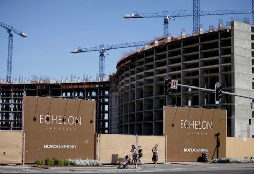 Boyd Gaming's Echelon project[/caption]
The land was bought by the Genting Group in 2013, and announced plans to build a Chinese-themed resort, building a replica Great Wall as well as convention center and indoor water park, with an opening on the site, many years after ground broke, predicted for early 2016.
*
[caption id="attachment_15865" align="aligncenter" width="500"]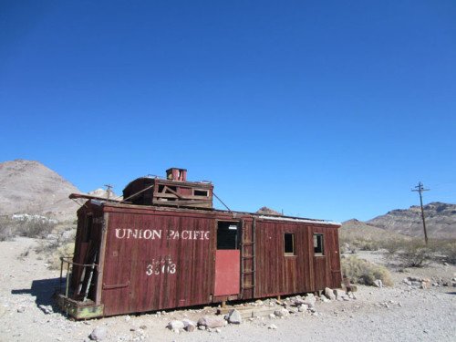 Abandoned train car in Rhyolite, Nevada[/caption]
**
The post Abandoned Vegas: Resorts Never To Hit The Jackpot appeared first on Sometimes Interesting.

On the east coast of the Black Sea, about 125 miles (200km) south of Sochi, sits the shell of a once-vibrant town. Ochamchire (also Ochamchira) was once a pleasant coastal retreat in Georgia, but an ethnic war following the dissolution of the former Soviet Union resulted in the territory becoming largely abandoned.
Now the city is part of the Abkhazia Republic, and less than a tenth of the city’s pre-war population remains. With entire city blocks abandoned, Ochamchire is a shell of its former self. Today many of those who stayed are trying to take care of what’s left for a population that won’t return.
cover photo courtesy Urbanomica

*
 The mountainous territory of the Greater Caucasus in northwestern Georgia is as beautiful as the region’s history is turbulent.
Not far are the eastern coastlines of the Black Sea, which offer hundreds of miles of sandy beaches with spectacular water views. Today this region is the partially recognized republic of Abkhazia, however it was a territory of Georgia until 1992.
Abkhazia has a rich history – both figuratively and literally – as it was once a Greek colony and later one of the wealthiest provinces in the former Soviet Union.
Ochamchire was the site of the ancient Greek colony settlement of Guenos. Later, the Romans left baths and medieval defensive stone walls still visible today.
After the Roman occupation the region saw a decline; by the thirteenth century the ancient Greek city became overgrown.
In the fourteenth century Genoese merchants established a trading post on the site of present-day Ochamchire. Known as Ala Gunda, the market became celebrated for its craftsmanship and sword trade.
After the Turkish invasion came decades of Turkish occupation. Turkish influence led to a renaming of the site: Oshimshir (later Ochamchire), from the Turkish “shamshir,” or sabre.
[caption id="attachment_15915" align="aligncenter" width="480"] Abkhazia coast during Balkan War, 1877[/caption]
*
[caption id="attachment_15918" align="alignleft" width="191"] courtesy Rob Hornstra[/caption]
Behind the economic growth of the twentieth century was a burgeoning divide between two groups: Those native to the Abkhaz region and the ethnic Georgians.
Northwestern Georgia was a war zone for much of the 1990s, and the result was a separate state. A de-facto, independent, and only partially recognized republic named Abkhazia.
The Abkhaz people consider their independence a liberation from Georgia, while Georgians believe that historically, Abkhazia has always been part of Georgia, and thus this was a secession. Regional tension had been high before, but when the Soviet Union was officially dissolved in 1991 it sparked revolutionary power struggles around its many republic states.
What followed in Georgia was an ethnic cleansing of Georgians in Abkhazia. Before the Georgian-Abkhaz Conflict, Georgians formed the largest ethnic group in Abkhazia, accounting for 45.7% of the population.
In 1992 a military confrontation between the Georgian government and Abkhaz separatists would begin a two-year war, leaving the separatists the victors.
[gallery type="square" td_gallery_title_input="Ochamchire Abkhazia" link="file" size="medium" ids="15919,15920,15921"]
photos courtesy Urbanomica
“I lived in Abkhazia 15 years ago, in the small town of Akhaldaba, Ochamchire district. Abkhaz attacked our village on September 16th, 1993. IT WAS IMPOSSIBLE TO HIDE anywhere from the bullets which rained down on us.”
-Leila Goletiani, prisoner of Abkhaz separatists
[caption id="attachment_15946" align="aligncenter" width="500"] source[/caption]
*
By the summer of 1993 the physical fighting in the Caucasus slowed as the war came to an end. The Abkhaz separatists had won but paid a price for freedom. Abkhazia had lost its industry, two-thirds of its population, and was in ruins.
The new de-facto independent state of Abkhazia was only recognized by Russia, not the United Nations or the world at large. This meant no trade with the rest of the free world, leaving Abkhaz towns such as Ochamchire without a “legal” economy.
That side effect would result in the departure of not only ethnic Georgians, but also the Abkhaz themselves, as many left searching for jobs and better opportunity.
[caption id="attachment_15923" align="aligncenter" width="480"] courtesy urbanomica[/caption]
*
[caption id="attachment_15924" align="alignright" width="199"] courtesy Rob Hornstra[/caption]
Amputating the region from Georgia cost an estimated 8,000 to 10,000 lives and displaced roughly 250,000 Georgians. More than 20,000 homes owned by ethnic Georgians were destroyed. Hundreds of churches, historical monuments, hospitals, and schools were also pillaged and destroyed.
The Organization for Security and Cooperation in Europe (OSCE) has recognized the ethnic cleansing thrice: First in 1994 at the Budapest summit, then in 1996 in Lisbon, and again in 1997 in Istanbul.
A 1994 report from the U.S. State Department described the actions:
“The [Abkhaz] separatist forces committed widespread atrocities against the Georgian civilian population, killing many women, children, and elderly, capturing some as hostages and torturing others ... they also killed large numbers of Georgian civilians who remained behind in Abkhaz-seized territory ... Those fleeing Abkhazia made highly credible claims of atrocities, including the killing of civilians without regard for age or sex. Corpses recovered from Abkhaz-held territory showed signs of extensive torture”
[gallery type="rectangular" link="file" td_gallery_title_input="Ochamchire Abkhazia" ids="15927,15928,15929,15930,15931,15932,15934"]
photos courtesy Urbanomica
In March of 2006 the Hague War Crimes Tribunal announced the results from its full-scale investigation. The Tribunal concluded it would prosecute and start hearings against the separatists who had committed war crimes.
By May of 2008 the United Nations officially recognized the atrocities when it adopted resolution A/RES/62/249, which “emphasizes the importance of preserving the property rights of refugees and internally displaced persons from Abkhazia.”
[gallery type="square" link="file" size="medium" td_gallery_title_input="Abandoned airport" ids="15935,15936,15937"]
photos courtesy Urbanomica
In July of 2008 Abkhaz separatists rejected a German-mediated peace plan and refused to attend peace talks in Berlin.
Russia has continued to get involved – and not always for the better. In 2008 the country sent troops into Abkhazia without obtaining the legal consent of Georgia.
The following year Russia planned to establish a Black Sea naval base at the port of Ochamchire, however plans were later abandoned when it was announced they were not practical.
[caption id="attachment_15939" align="aligncenter" width="500"] courtesy urbanomica[/caption]
*
[caption id="attachment_15950" align="alignright" width="240"] courtesy Tasha Bordeaux[/caption]
The city of Ochamchire (Abkhaz: Очамчыра, Ochamchyra; Georgian: ოჩამჩირე, Ochamchire; Russian: Очамчира, Ochamchira) is the administrative center of the eponymous district.
It first earned city status in 1926, although it hosted a Batumi Black Sea border ship detachment since 1923. In 1967 it became the base of the 6th separate border patrol brigade (which later relocated in 1996).
While under the Soviet umbrella the region experienced relative prosperity. From 1921 until 1931 Abkhazia enjoyed the same status as Azerbaijan, Kazakhstan, and other Soviet republics. It gained factories, ports, and a railroad, resulting in an economic boom.
Canning, farming, oil, tea, and tobacco all became major industries.
[gallery link="file" td_gallery_title_input="Ochamchire Abkhazia" ids="15940,15941,15942"]
photos courtesy abandonedplaces.livejournal.net
But Ochamchire would suffer heavy losses throughout the conflict. Numbers vary, but it is estimated 400 Georgian families were killed in Ochamchire during the Abkhaz offensive. The Kochara district alone saw 1,000 homes destroyed.
[caption id="attachment_15944" align="aligncenter" width="500"] courtesy Granta[/caption]
[ See official Abkhaz website for Ochamchire ]
*
[caption id="attachment_15949" align="alignleft" width="180"] courtesy Tasha Bordeaux[/caption]
Physical conflict has subsided although the region is far from healed. Ochamchire still maintains a small population which acts as a skeleton crew to keep portions of the town operating and tidy.
But most of the town is eerily empty. You wouldn’t know the town was occupied if not for the occasional sound of a woman sweeping her porch. Visitors have reported seeing more stray animals than people.
The majority of town still wears scars from war. Almost everything have been vacated; empty houses still have outlines of flames above blackened windowless frames. Roofs seem to be sporadically missing tiles, some offer vegetation a place to escape from inside.
Roads were shelled into Swiss cheese, and the town’s train station is still in shambles. The stump of a sculpture sits in front of a destroyed hospital, robbed of its feature decades ago. Soot stains are tattooed across entire neighborhoods as a grim reminder of the town’s past.
 Some homes had effects left behind, items that managed to escape the pillaging over twenty years ago; an old TV or typewriter here, a broken desk or wardrobe there.
Despite the turbulent history there are places in the district worth visiting if one has the opportunity, including the aforementioned ruins of the ancient Greek colony of Guenos, the giant Abriskila Cave with its underground stream Achkitizgo, and the ancient Mokvi Cathedral (pictured above right).
Tourism opportunities are understandably limited with the economic choke-hold on the region, but the people who remain are warm. Much of the youth lack their parents' vitriol toward the other side. Elders vividly remember the war; nobody is proud of it. Few can easily or often discuss such matters.

Hopefully lessons are learned. Similar to the forced-evacuation of the abandoned resort in Varosha, Cyprus, the Georgians separated from their homes in Abkhazia were merely collateral damage to a greater ideological difference.
It is a shame that such disagreements can prevent coexistence. One has to wonder if the result is better than the previous arrangement. Did the removal of ethnic Georgians improve things for the Abkhaz?
If the fortunes of Ochamchire and its former residents are any indication, it would appear not.
[caption id="attachment_15925" align="aligncenter" width="500"] A refugee kommunalka in Tbilisi. A kommunalka is an apartment building with shared kitchen & bath. This building was used as student housing until the Georgia-Abkhazia war of 1992-93, when it became home to Georgian refugees from Abkhazia. (courtesy Rob Hornstra)[/caption]
*
Watch: A Drive through Ochamchire
[youtube="https://www.youtube.com/watch?v=z2i5mBIwM5s"]
**
The post Ochamchire Abkhazia: Casualty of War appeared first on Sometimes Interesting.

Long Beach, California is known for its beaches and sunny weather. It has one of the world’s largest shipping ports and is a major player in domestic oil production. Douglas Aircraft chose the city to house its largest facility, and Henry Ford built Model A’s here. Also, astrologers and psychics established temples (see more about online psychics).
The Psychic Temple became a Long Beach landmark for spiritual learning in 1905. When its founder was run out of town years later, it evolved into the American Hotel. For decades the building seemed to defy progress and barely escaped demolition. Thanks to the work of a passionate few, the hundred year-old building will have the opportunity to last another century.
cover photo courtesy psychictemplelbc.com

*
[caption id="attachment_15810" align="alignright" width="220"] W. R. Price[/caption]
The Psychic Temple was founded in 1905 by former Baptist preacher Dr. William R. Price. Born in Tennessee in 1863, Price had become known as a demonstrator, hypnotist, lecturer, and mesmerist after his travels around the Southeastern United States.
He preached male continence as a form of contraception and practiced a type of acupressure, in which he healed people by touching certain nerves.
The silver-tongued Price was controversial but convincing, acquiring new followers at each stop. He was also nomadic, fathering five children in five states. Legal issues seemed to follow him, and were the ultimate catalyst for his move west from Atlanta.
“Dr. Price says he can take a woman in his arms with the purest thoughts and can kiss a girl without a thought of evil— so strong is his self-control.”
- Rosella Bates, Price follower
Around the dawn of the twentieth century he made his way to California, initially giving lectures and speeches in San Francisco before settling in Long Beach in 1904. Initially Price was a hit in California.
An early newspaper article recounted his arrival:
“He came to Long Beach one year ago unheralded. Quietly he announced a series of lectures on Psychic philosophy and phenomena. He attracted a few of the curious and those who were diseased. Cures were reported. Classes for instruction were formed and soon he began to attract public attention. When he had gathered a membership of 200 he set about building a temple for his use.”
[caption id="attachment_15812" align="aligncenter" width="500"] Across the street from the Psychic Temple[/caption]
The following year William Price established the Psychic Temple, a new headquarters for his Society of New and Practical Psychology (also known as the Holy Kiss Society).
Its motto: “Health and happiness for all.”
 By all accounts Price operated the Holy Kiss Society as a business. To pay for the new Psychic Temple, followers had to become investors. Members contributed their means toward a stock-holding company, and in return received shares.
Lots were purchased for enlightenment. For non-members, Price charged $10 per lesson. Followers were encouraged to mortgage their homes and also convince friends and family to “invest” in the Society.
The construction estimate in 1905 was $11,000, however its ultimate cost to build was somewhere between $20,000 and $25,000.
With funding from his followers, William Price built the Psychic Temple at 224 East Broadway in Long Beach, California.
 The groundbreaking took place on July 10th, 1905 for what was supposed to be the “first building in the history of the world erected and dedicated to psychological work.” The cornerstone was laid six months later, on October 1st, 1905.
Flaws in Price’s plan manifested early, and once again the self-described psychologist found himself in legal trouble. Three years after opening, the Psychic Temple was unable to pay its debts. Price filed suit against his investors (née followers) in 1908 over unpaid items to the Society. Stockholders claimed they were under Price’s spell of “hypnotism and telepathic influence.”
The trial lasted more than two years, and William Price failed to make his case. In the meantime his fortunes had been exhausted in the courtroom. Price was forced to sell the Psychic Temple in 1911 to fund the settlement and legal fees.
William Price eventually left Long Beach in 1919, when he started the New School for Applied Christian Psychology in Los Angeles. In 1923 Price was arrested for fraud and divorced over his adultery. He died in 1925.

*
The building itself was designed by the same architect responsible for Long Beach’s Masonic Temple, built in 1903 and still standing today. Architect Henry Starbuck used a similar Romanesque Revival style on the Panel Brick Psychic Temple, which features distinctive arches with cast keystones and an upper façade boasting a corbel table.

Questions surround elements of the original appearance and floor plan as a 1930 earthquake damaged much of the city, and permits were rather loose at the time. It is believed the first floor was initially one giant open area with a single set of stairs in the back; a second set of stairs on the far end were added in the 1920s. The building originally had finials along the top parapet, believed to be lost during the earthquake.
 To provide light for the basement, glass was embedded in the sidewalks above, reinforced by cold-twisted steel rods. These basement prisms are still there, but barely visible (pictured at left). “You can hardly see the glass,” says Long Beach-based historian Stan Poe.
The building’s main staircase wasn’t grand but it was nice. Above the stairs was a skylight that was painted and lit up the lobby.
Rooms of the upper levels were small, contained no bathrooms, and had just enough space for a single bed. During the days of the Psychic Temple these were likely meditation or prayer rooms; in later years these became the hotel rooms and apartments.
*
 Anna Sewell purchased the Psychic Temple for $2,910.09 at auction, less than a tenth of its estimated value of $35,000. Sewell’s bid was the only one, and as the largest shareholder in the former Psychic Temple venture, the deal was an easy one.
Sewell did not have immediate plans for the building upon assuming the deed, but she did inherit its $12,000 mortgage. She celebrated by removing Price’s name from the plate glass with acid and chiseling his name off the cornerstone.
Anna Sewell re-opened the building as the American Hotel in 1911, however her limited resources and the building’s poor design for such an application resulted in the building becoming more of a flophouse.
A narrow stairway on the west side of the building led to the entrance of the American Hotel. Once inside, guests were on the building’s second floor, which contained the hotel’s lobby and soaring ceilings, open to the balconies and skylight above.
Early rooms at the American Hotel occupied the second and third floors. They were small and simple, having nothing more than a small corner sink and a rudimentary wooden closet. There was one bathroom per floor, located at the end of the hall.
 The first floor contained retail storefronts, which in 1930 included a small stationery and notions shop and a cigar factory. It was once a popular speakeasy and hangout for GIs during World War II. In later years the first floor of the former Psychic Temple would house a barbershop, locksmith, nail salon, and shoe repair business.
Over the years the American Hotel continued to deteriorate. It was never competitive, ill-equipped to serve guests as well as newer hostels and hotels which featured larger rooms with built-in bathrooms. Consequently, the American Hotel found itself typically home to those below the poverty level.
Its history in Long Beach is what seemed to save the former Psychic Temple throughout the 1960s and 70s. In an attempt to preserve the dilapidated building, city officials declared the building a landmark in 1989 (16.52.480).
(click thumbnails to enlarge)
[gallery td_gallery_title_input="American Hotel" link="file" columns="4" type="rectangular" ids="15823,15824,15825,15826,15829,15830,15831,15832,15833,15834"]
photos courtesy interTrend and JRVD
A 1992 account from a resident paints a picture of the hotel that became an apartment building for those down on their luck. A former resident described her 12x12 room as a “tiny little room without a kitchen or bathroom that was crawling with huge cockroaches.”
Residents cooked on hot plates, lived out of crates, and slept on futons while sharing communal bathrooms at the end of the fourth floor hallway. The building didn’t have air conditioning, but some of the privileged few had window units in their rooms.
[caption id="attachment_15827" align="aligncenter" width="500"] courtesy Lindsay Ingram[/caption]
*
 Meanwhile, the building had become an eyesore as it had slowly been allowed to crumble over the last several decades. The city did not want to demolish it, but it needed a reason and a suitor to save it.
In 1998 the Los Angeles Council of American Youth Hostels proposed to turn the Psychic Temple into an $8-million, 200-bed facility. The concept included using the antiquated building as its regional headquarters, but the plan fell apart when the group was unable to secure financing.
The council collaborated with Artspace, a nonprofit real estate developer with experience in building artists’ lofts. However after the developer looked at the building, they chose to not move forward with the idea.
According to Artspace, rehabilitating the building proved too costly to save it. Part of the challenge was updating the building; a preliminary total to make it structurally sound (upgrading the building’s utilities, making it safer from earthquakes, etc) reached $11 million.
Once again the city of Long Beach came to the rescue, purchasing the former Psychic Temple at a tax auction in 1998. Long Beach Development Services (LBDS) Director Amy Bodek believed she got a deal when she purchased the building for $200,000.
[caption id="attachment_15840" align="alignleft" width="201"] courtesy Lindsey Ingram[/caption]
In 1998 the hotel was occupied by 23 long-term residents, the majority of whom were on month-to-month plans. The building was worn and barely serviceable. The interiors of the rooms were in fair condition and contained surplus hotel furniture, most of which was still in good condition. The first floor retail spaces were in the worst state of repair and a looming safety hazard; the basement was nigh impassable.
By August of 2000 the American Hotel residents had been vacated, and the former Psychic Hotel building was acquired by the Long Beach Redevelopment Agency (RDA) for $416,000 in tax increment funds.
It was the city’s hope this action would help spur redevelopment of the building. However as downtown Long Beach's fortunes improved, the city realized it would become too costly for a public-financed renovation.
For the next ten years the RDA attempted to find a development partner for the property. Bodek recalled the turnstile of development proposals: “A youth hostel, a residential loft project that would have rehabilitated the building, another residential project that would have partially demolished the building, an office project that would have saved the historic facade but built a new small creative office space building behind it.”
[caption id="attachment_15841" align="aligncenter" width="500"] courtesy Lindsey Ingram[/caption]
None of them proceeded – partly due to financing issues – but it didn’t help attract suitors that the building was protected as a landmark and unable to be razed.
It was not until 2010 that a partner would be located to develop the old Psychic Temple.
*
[caption id="attachment_15836" align="alignleft" width="260"] courtesy JR van Dijs[/caption]
In February of 2010, the RDA board voted 5-0 to approve a six-month negotiating agreement with Urbana Development, LLC.
Both sides discussed the costs and possible reuses for the three-story brick building, including ground-floor retail and restaurant spaces, along with office spaces for creative businesses on the upper two floors. However discussions were tenuous at best, given the budgetary-forced dissolution of the Long Beach Redevelopment Agency in 2011.
To Urbana’s credit, it made improvements to the site and performed interior demolition and façade tile removal – even while the RDA faced its own financial crisis. For their efforts Urbana received a certificate of appropriateness from the city’s cultural heritage commission.

Urbana also produced cost estimates for the building’s restoration and received approval under the California Environmental Quality Act exemption.
But Urbana was merely the developer, not a future occupant. And without the $200,000 promised subsidy from the dissolved RDA, the developer was now assuming one hundred percent of the risk. Another danger was the lack of an ally in city hall; a municipal oversight board regulating former RDA obligations and the California Department of Finance could object to the transfer, putting the entire project in jeopardy.
[gallery type="square" link="file" ids="15837,15838"]
photos courtesy JR van Dijs
*
The deal lacked a tenant partner until 2012, when marketing agency interTrend Communications joined forces with developer JRVD from Urbana to form Temple Creative Realty, LLC.
Under the new partnership, interTrend would work out of the 14,500 square feet of top two floors. The ground level, encompassing nearly 5,000 square feet, would be leased to retail and restaurant businesses.
[caption id="attachment_15842" align="aligncenter" width="500"] courtesy Lindsey Ingram[/caption]
"Right now, [the building] is a physical manifestation of Long Beach's changing façade. There's an element of history and an element of the future."
- Jan van Dijs, JRVD
In March of 2012 a resolution (File #12-0284) was submitted to the city for a vote. The resolution was to approve a development agreement for the old Psychic Temple building with Temple Creative Realty, LLC. The city approved the resolution in April of 2012.
[caption id="attachment_15843" align="alignright" width="186"] courtesy Lindsey Ingram[/caption]
The Disposition and Development Agreement (DDA) had been approved, but the terms of the agreement were met with enough skepticism to find their way to the oversight committee. One of the speed bumps appeared to be the RDA’s cost basis for the property ($416,000), versus the sale price to Temple Creative for $1.
According to Long Beach Development Services (LBDS) Director Amy Bodek, appraisals in September of 2010 and April of 2012 both indicated the property had a negative land value.
“The amount of dollars that are necessary to renovate the building and bring it up to code renders the entire value of the property, including the land and the building, a negative value of approximately $331,000.”
- Amy Bodek, LBDS Director
Bodek argued if the cost of rehabilitation are considered, Temple Creative would be paying far more than one dollar for the property. The resolution was eventually approved, allowing the rescue and redevelopment of the Psychic Temple to proceed.
[caption id="attachment_15844" align="aligncenter" width="500"] courtesy Lindsey Ingram[/caption]
*
[caption id="attachment_15846" align="alignleft" width="180"] courtesy Lindsey Ingram[/caption]
According to Richard Lewis, Project Manager for JRVD and the Psychic Temple, when crews began working on the front of the building they uncovered cast-iron columns that had been hidden for years.
“We found that there once was an arch where the new entrance to the second floor will be.”
Unfortunately the first floor retail spaces have been modified so many times over the years, most of the historical elements on the ground floor level have been lost. However this has not deterred JRVD, interTrend, or those who approved the $2 million dollar makeover.
Work began in 2012, starting with a complete seismic retrofit. JRVD removed the alterations made in later years and restored the salvageable original wood-framed windows. Façade elements were restored, and the sidewalk (with its coke bottle glass inserts) was preserved.
Most importantly, JRVD completed a full-frame build out of office space across three floors and the basement.
 While JRVD was handling the core and shell of the renovation, interTrend went to work on interior design. One step was to commission artists to add custom touches to the Psychic Temple, such as James Jean, who was brought in to add some woodcarving artistry to the Psychic Temple’s new library.
“We love the history of it and I think in building it and renovating it we want to tell that story as well, whether it be the Psychic Temple or the American Hotel.”
- Julia Huang, CEO of interTrend

While the building is not yet complete, significant progress has been made and the building has been saved.
The former Psychic Temple and American Hotel is currently the second-oldest commercial building in downtown Long Beach, California (just behind the Long Beach Masonic temple, built in 1903).
[caption id="attachment_15852" align="aligncenter" width="500"] Psychic Temple in 2015 (image courtesy Urbana Development)[/caption]
**
The post The Psychic Temple of Long Beach appeared first on Sometimes Interesting.

While it is unrealistic to expect every single property market in the world to behave in exactly the same manner, the differences between some are quite incredible. While the UK sector struggles with a significant lack of housing supply, for example, the U.S state of Ohio has a number of excess forgotten houses sitting idle in the marketplace.
There are multiple reasons for this, but the fact remains that there are some large and impressive private residences in Ohio that have been left to rot by their owners. This has created entire ghost towns in the region, while also placing an intolerable strain on active properties in the market.
*
The range of abandoned homes in Ohio also has to be seen to be believed, with everything from derelict, former family abodes with no chance of restoration to fully furnished properties that appear to have been abandoned suddenly and left in a state of genuine disrepair. These structures create a haunting and unfortunate landscape, which perhaps reflects the impact that austerity has had on thousands of households throughout the state.
This is an important consideration, as it offers some context about why so many homes have been abandoned. Some regions around the word have yet to recover from the impact of recession, for example, with Ohio a relevant case in point.
Many of these forgotten houses have simply been abandoned prior to foreclosure, as they await the process of being reclaimed, restored and listed on the open market. Probate property is also a large issue in Ohio, as these homes are usually part of a deceased individuals’ estate and can take longer to sell.
While probate property is often sold through official auction houses for a vastly reduced cost, it must be remembered that these buildings have often been neglected and left to run down. This is especially those that have been left to the state, as private buyers must purchase individual houses, restore them to their former glory and then successfully sell them on the market.
The drive to generate a desired profit makes this a time-consuming profit, while it also explains where Ohio is littered with forgotten houses, or probate properties in various stages of disrepair.
*
While parts of Ohio may currently resemble a ghost town, there is hope that the region will rebound and achieve sustained economic growth in the future. After all, the global economy is gradually improving, while the high volume of probate and foreclosed homes will eventually be restored and delivered to local residents and families.
For now, however, Ohio’s property market remains mired in decline and provides a stark contrast to the UK.

**
The post Ohio’s Forgotten Houses: A Failing Property Market appeared first on Sometimes Interesting.

One hundred years ago utility companies used massive steam-powered engines to pump water throughout communities. These five-story behemoths were impressive for their time but had become obsolete decades before the end of the twentieth century. As infrastructure was upgraded, most were dismantled and sold for scrap; few managed to survive.
One survivor is in the long-defunct New Milford plant of the former Hackensack Water Company in Oradell, New Jersey. The waterworks was established in 1882 and operated continuously for over one hundred years before closing in 1990. Over the last twenty-five years it has avoided several close calls with demolition.
Today the plant's future is not yet guaranteed, but the buildings still stand because of fortuitous circumstance, government indecision, and the hard work of a passionate few.
*

Map it! (also Street View)
Toward the end of the nineteenth century, the United States’ lack of a centralized water system was a significant contributor to the spread of disease. Fragmented wells and poor quality drinking water wrought havoc on the population via illnesses such as typhoid fever.
Various waterworks were formed around the country to centralize and control water quality and supply. The Hackensack Water Company (HWC) filled this role for New Jersey communities in 1881, when it signed a 10-year contract with the city of Hoboken to supply its drinking water.
[caption id="attachment_16043" align="alignright" width="260"] Van Buskirk Gristmill[/caption]
Van Buskirk Island, which straddles the New Jersey boroughs of New Milford and Oradell, was chosen by HWC as the site for what would be called its New Milford Plant. The artificial island was formed in 1802 when dams were added to support the mills along the Hackensack River. It was attractive to industry because of its proximity to rail supply lines and a reliable water source.
In 1837 John and Jacob Van Buskirk purchased the island and established J. & H. Van Buskirk Gristmill (pictured above right), which operated on the southwest corner of the island for over forty years.
Things changed for Van Buskirk Island in November of 1881 when Hackensack Water Company purchased the island for $50,000.
The company's first order of business: Laying miles of pipe.
[caption id="attachment_16042" align="aligncenter" width="500"] Map of Van Buskirk Island, circa 1881[/caption]
*
[caption id="attachment_16046" align="alignleft" width="280"] courtesy Jack Surran[/caption]
The construction of the plant's red brick Romanesque Revival buildings took place from 1882 until 1911. First to be erected were the Pumping Station and large coal shed/boiler house, the inner workings of which were designed by the company’s chief engineer and water system pioneer Charles Benjamin Brush.
Brush’s system was revolutionary for the time, including a massive infrastructure complex which extended two levels below ground. The grand opening took place in 1882, however construction from expansion and updating would be an ongoing process for the next seventy years.
The early crown jewel of the Hackensack Waterworks was its Worthington Duplex Pumping Engine, a steam-driven behemoth capable of delivering 3.8 million gallons of water per day to Hoboken’s 30,000 residents.
[caption id="attachment_16047" align="aligncenter" width="400"] Worthington Duplex Pumping Engine[/caption]
*
[caption id="attachment_16053" align="alignleft" width="240"] Number 3 pump[/caption]
As the population grew, so did the need for fresh water. In 1886 another Brush-designed building was added to house a new 10 million gallon-per-day Worthington. Another building was added in 1891, enclosing two more Worthingtons to further increase capacity.
The two-story addition the pump station was built in 1898 to house two vertical triple expansion pumping engines (numbers 5 & 6). This modification, which included the chimney stacks seen today, helped increase output by 150%.
In 1901 a new reservoir was created in Oradell, New Jersey just a half-mile from the New Milford plant to help the Hackensack Water Company keep up with demand. Five years later the Hackensack Water Works Filtration Plant was formally opened, in 1906. It used a rapid sand filter in a twelve million gallon coagulating basin constructed just east of the main building. The Filtration Plant housed an impressive four-story coagulant facility, which included a laboratory for analyzing and testing both the raw and filtered water supplies.
[caption id="attachment_16048" align="alignright" width="220"] Old Pump Number Seven[/caption]
From 1911 until 1912 the largest extensions to Hackensack’s New Milford Plant were completed. These additions introduced Pumps 7, 8, and 9 and increased water output by thirty-five million gallons per day.
Twenty million of those gallons came from the mammoth Pump No. 7 (pictured at right), an Allis-Chalmers Vertical High Service Pump. The fifty-foot leviathan was capable of moving more than 600 gallons of water per revolution of its thirty-two ton flywheels.
In 1912 the Filtration Plant was expanded to house eight new filters. This raised capacity to forty-eight million gallons per day. Improvements in technology dictated the upgrade to the No. 3 pump in 1915. The Allis-Chalmers No. 3 could pump thirty-six million gallons per day, nearly twice the capacity of the larger and older No. 7.
The water utility operated the steam pumps for over 70 years, keeping them polished and in immaculate working order until the plant closed in 1990.
[ Did you know? Activated carbon water treatment was pioneered by Hackensack Water Company sanitary engineer George Spalding in the 1920s, and later implemented at the facility in Oradell around 1931. ]
*
[caption id="attachment_16051" align="aligncenter" width="500"] The diagram above shows the movement of water through the Hackensack Water Works facility. Water was brought from the Hackensack River via the intake canal where the first large screened filter removed leaves, branches, and other large debris. From here the water was piped through the Pumping Station by pumps that moved the raw water to the Coagulation Basin. Fine particles settled to the basin floor through sedimentation and the addition of treatment chemicals. Once finished with its slow progression through the Coagulation Basin, the water was gravity-fed to the Filtration Plant. The water then moved through beds of sand and powdered-activated charcoal. This filtration process guaranteed delivery to customers of the highest quality clean water. Pipes transported the water from the Filtration Plant to the Pumping Station. Pumps then delivered the water to customers in Bergen and Hudson County (courtesy Rutgers).[/caption]
*
In addition to the visible buildings, the site contains a vast underground network of pipes several stories below ground. Due to the plant’s location in a flood plain, the subterranean network of pipes were built to withstand regular inundation by water.
The final building expansion to the Filtration Plant was completed in 1955; six filters raised the plant’s capacity to seventy million gallons per day. By the early 1960s the Hackensack Water Company had reached its zenith, pumping over 100 trillion gallons of water per year.
[caption id="attachment_16050" align="aligncenter" width="500"] Hackensack Water Company's dates of expansion (courtesy Rutgers)[/caption]
*
[caption id="attachment_16055" align="alignleft" width="180"] Intake canal[/caption]
Advances in water technology and regional population growth meant it was only a matter of time before the old steam engines and the red brick buildings they called home would be obsolete.
Functionally this occurred for the New Milford plant by the middle of the twentieth century. It was a regional need for additional capacity that kept the venerable pumps online until the 1980s.
In 1964 the Hackensack Water Company opened a state-of-the-art facility in Haworth, New Jersey. This treatment plant was more advanced and cleaner operating, capable of moving another 50 million gallons per day for the water company at a lower cost. The operation on Van Buskirk Island would gradually be phased out as responsibilities were transferred to the newer Haworth facility.
[caption id="attachment_16056" align="alignright" width="280"] HWC Plant in the 1960s[/caption]
From the early to mid-1970s the plant’s operations continued to shrink; by the end of the decade it had become a financial burden to its operators, who by this time had elevated their search for a way out. In an effort to curb rising rates, the state Board of Public Utilities mandated in 1983 that the water utility reduce its land holdings.
Decommissioning was still six years away when the water company began transferring property and land rights in 1984. Former watershed land encompassing some 700 acres across 50 parcels was donated to nearly a dozen Northeast Bergen County municipalities.
*
For the old New Milford filtration plant on Van Buskirk Island, the operational end would come in late spring of 1990. By this time an expansion of the Haworth plant had been completed, allowing for the water company’s final capacity shift to occur. When the facility was shuttered on May 31st, 1990, it had served the community for 108 years.
By this time closing was more formality than theater; the jobs had been long gone, vaporized by steam engines which anchored the plant in the nineteenth century.
[caption id="attachment_16054" align="aligncenter" width="500"]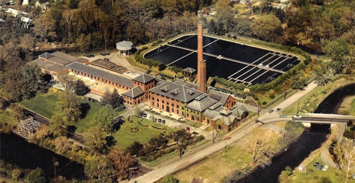 Aerial view of Hackensack Water Company's New Milford Plant.[/caption]
The New Milford water filtration plant was closed for a year before Hackensack Water Company announced action. In August of 1991 the HWC offered to give Bergen County a mile-long stretch of riverfront property in Oradell and New Milford, including the hundred year-old buildings of the plant. The gift included the old water plant buildings and 47 acres, valued between $3 and $4 million dollars.
Bergen County Executive William “Pat” Shuber was initially optimistic, but after delving into the financials of the matter, started to see problems. Oradell Mayor Carolyn Hague was less enthusiastic, immediately noting her borough’s loss of about 42 acres of water-company property from local tax rolls, which would cost Oradell nearly $100,000 a year. "That bothers me a lot," said the wary mayor. "I don't know whether this is a big, generous gift to the county or not."
Removing the property from its books would at least have been a gift for the water company. The utility's chairperson, Robert A. Gerber, acknowledged as much in a statement: “There would be some tax advantages for the company in donating the property for public use.”
[caption id="attachment_16059" align="aligncenter" width="500"] courtesy Jack Surran[/caption]
Mayor Hague was more pointed in her comments during a November 1991 conference: “…I want to make sure we are not short-changed. It is good for the water company because of the tax relief it would get, and also because it would not have to maintain the property.”
By September of 1992 the county had yet to accept the water company’s gift. Bergen County was not interested in maintaining or paying taxes on it, so officials weighed demolition costs. Initial reports seemed to indicate it would be too costly to renovate the structures, and that their “suitability for other uses was questionable.”
Estimates to raze the site ran between $2 and $6 million dollars. County Executive Schuber would accept the land with the stipulation that the water company pay for the $2 million to $4 million razing of the plant.
[caption id="attachment_16045" align="alignleft" width="187"] courtesy Jack Surran[/caption]
Alternatively, a study showed an immediate $1 million to $2 million outlay was needed to repair and stabilize the buildings – and subsequent maintenance would cost $110,000 a year.
The water company wanted the buildings off its books and was willing to accommodate the County if necessary. For example, the utility agreed to pay taxes and the maintenance costs for the site until the County could find a developer and approve a use for the property. It also reluctantly agreed to finance the demolition should no developer plans develop.
With conditions met, in late September of 1992 County Executive Schuber recommended the county accept the gift – however the final stamp of approval would still have to come from Bergen County’s Board of Freeholders.
*
Once word of potential demolition reached the public, members of the community displayed outrage. A debate ensued with potential preservation grant dollars driven by an argument whether the hundred year-old site held historical significance, or was merely an antique.
County Executive Schuber was blunt in his financially driven reasoning: “…if the building has no [historical] significance, I don't see how it could be preserved. I don't see where the money would come from."
The water company conducted a historical study in 1991. According to a company spokesperson, the study found "some historical value, but nothing of overwhelming significance." The study also said the water pumping station and filtration building "don't lend themselves easily to adaptive reuse" because of their “cavernous nature and the heavy machinery and piping inside.”
[caption id="attachment_16058" align="aligncenter" width="550"]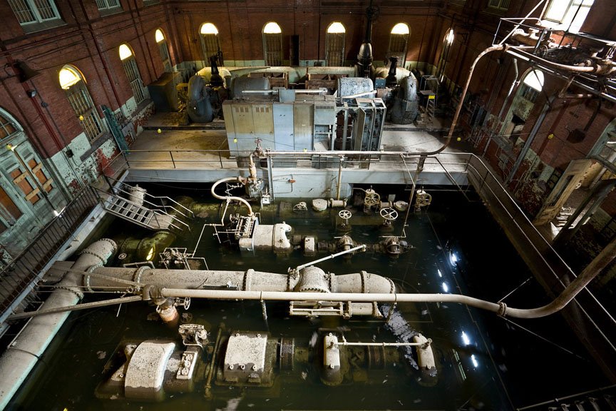 Inside the abandoned plant (courtesy Ian Ference)[/caption]
County officials tempered objections by announcing a historical and archaeological survey would take place before any decision is made. Estimates to redevelop the site approached $9 million dollars; the county agreed to also seek development proposals from outside parties who could offer their own financing.
Six proposals came through in June of 1993, two of which piqued the interest of county officials. One of the plans proposed converting two of the century-old buildings into fifty units of affordable housing; another converted one building into residential units and another into a small shopping mall.
[caption id="attachment_16061" align="aligncenter" width="500"] courtesy Chip Renner[/caption]
Meanwhile, the pace of the county’s decision making was beginning to worry the water company, who was still on the hook for the maintenance costs and taxes on the property until a decision was made.
*
[caption id="attachment_16076" align="alignleft" width="173"] courtesy Jack Surran[/caption]
It took several studies and two years of talks, but on October 20th, 1993, Bergen County finally agreed to accept the land gift from the water company. To facilitate the deal, the water utility agreed to pay the county $1.1 million toward either demolition or re-use of the New Milford site, surveyed at 64 acres instead of the previously estimated 47.
Regarding the tax revenue shortfall, the water company agreed to pay the taxes for the remainder of 1993 with the county picking up the bill for 1994, paying a total of about $100,000 to the two affected boroughs. The deal assumed that, by 1995, the property will have been demolished or redeveloped. In the interim, the old New Milford plant on Van Buskirk Island was added to the county park system.
In December of 1994 a high school teacher and his students spent several days inside the plant salvaging steam-engine parts and tools, hauling them back to their school for refurbishment. The equipment became part of a collection of 30 operable antique steam-driven turbines restored by students.
[caption id="attachment_16067" align="aligncenter" width="500"] courtesy Mark B. Thompson associates[/caption]
February of 1995 witnessed a small push for converting the New Milford plant into affordable senior housing and an engineering museum, but as before the problem was a lack of money. The following year non-profit PENWAL Corporation envisioned building 35 affordable senior housing units and 35 market-rate units, a 5,000-square-foot senior citizens center, a 55,000-square-foot retail building including 8,500 square feet of smaller shops, and close to 400 parking spaces.
Residents feared this would disturb the solitude offered by the wooded Van Buskirk Island. The developer claimed the supermarket and shops were necessary to subsidize the building restoration and housing costs. With the two sides unable to reach an accord, the plan stalled.
By June of 1996 Bergen County had enough; officials gave Oradell until the end of August to decide what to do with the land. If the borough could not find a suitor to redevelop, the property would be razed.
"… we want to work with the borough to come up with a plan that the public supports. But there comes a point when we can't wait any longer."
- William “Pat” Schuber, Bergen County Executive
[caption id="attachment_16038" align="aligncenter" width="500"] courtesy Mark B. Thompson Associates[/caption]
The city pleaded for more time to give developers time to put together proposals. Schuber extended the deadline to November 1st, 1996. This allowed several proposals to roll in.
First was PENWAL, with its second attempt, submitted in August of 1996. Their new proposal was for a retirement home community, including a nursing home, senior care, and other housing for the elderly. Other proposals included a Korean Catholic Church and headquarters for a non-profit preservation group.
By October of 1996 city officials had five more proposals to evaluate, including a valve assembly plant, multifamily housing, and a museum featuring an art gallery and bookstore. None would ultimately pass muster, which forced Oradell Mayor James Snedeker to ask for more time. Schuber complied, extending the deadline until December 1st, 1996.
“The bulldozers aren't coming in Nov. 1st… Why are we rushing? This is the first place where public water came from in the county. We don't want to lose that.”
- Mary Lang, Oradell resident
*
[caption id="attachment_16062" align="alignright" width="250"] courtesy Chip Renner[/caption]
The disconnect stemmed from what initially seemed to be contradicting goals.
Local preservationists desired a solution that didn’t include razing the buildings or adding retail businesses, fearing an increase in noise and traffic. Bergen County officials simply didn’t want to be on the hook for administrative and maintenance costs, preferring the safe route of razing the buildings and transforming the space into a passive park.
Oradell was not enthusiastic about losing the taxable revenue as a result of converting the site into a park; rather, they were interested in redevelopment – possibly preserving the buildings if it could be subsidized by the other businesses operating out of the old plant.
Mayor James Snedeker reminded Bergen County officials: "This land used to be a ratable four years ago. We used to get $81,000 to $84,000 from it and now it's off the tax rolls."
[caption id="attachment_16087" align="aligncenter" width="500"] Hackensack Water Co.'s plant in Oradell, NJ (courtesy NorthJersey.com)[/caption]
Time was running out; none of the proposals ticked all the boxes. Unfortunately for the preservationists, the fallback was the county’s preferred solution of razing the buildings and converting the site to a passive park.
Oradell officials felt that financially, their hands were tied. In November of 1996 the city decided the passive park concept was the most feasible course of action.
In December an eight-member task force was assembled to consider the logistics of such a move. The task force, appointed by Schuber, consisted of four county officials and four city residents. Their mission was to draw up a plan and secure funding for the site in the next 18 months.
[caption id="attachment_16060" align="aligncenter" width="500"] Basement of the engine room (courtesy Ian Ference)[/caption]
*
By the spring of 1997, not much had changed. As had been the problem for the last seven years, the task force was having a difficult time sourcing funding for site preservation. Specifically, the group hoped to preserve the pump house building, which contained the “Old Number Seven” steam engine.
The task force was split on whether to raze the entire site or preserve a part of the former water plant. An eventual rift formed within the group, which began to exhibit more secrecy. In August of 1997 the group’s cards were so close to their vest, the public complained about the task force’s lack of transparency.
[caption id="attachment_16083" align="alignleft" width="278"] Pump Number 7 (courtesy Donald Martino)[/caption]
A volunteer group applied for a $1.2 million state historic preservation grant and citizens in favor of preservation applied for recommendation to listing the former water plant on the Register of Historic Places.
Schuber, knowing that being added to the register would slow the metamorphosis into a passive park, asked the state historic preservation office to delay placing the site on the register until the task force had developed its plan.
In September of 1997 the Bergen County freeholders were split in their voting (4-3) of the best way to develop the nature preserve. A consulting group was hired to analyze different options and present them to the group. Said one task force member: "There are two different camps, one that says we ought to raze the buildings and make it a nature park, the other that says we ought to preserve them. When the study is done, we are going to know the pros and cons of doing both, and at that point we will make a final decision."
Meanwhile, the rift in the task force grew. In October one task force member claimed she was not told that a consultant had been hired to help them until she read about it in The Record last month.
[caption id="attachment_16088" align="alignright" width="280"] courtesy 150by70[/caption]
The study found complete demolition would cost approximately $1.8 million. Costs to preserve the pump house and part of the adjacent water filtration building were estimated to be $14.6 million. Finances were looking dire; the group had just $800,000 remaining from the $1.1 million donation by the former Hackensack Water Company (now United Water).
At the time the only outside funding secured was a $575,000 grant through the state’s Historic Trust – but this money was contingent on the preservation of the entire pump house and the oldest sections of the water filtration plant. The aforementioned study estimated this cost at nearly $15 million, meaning the $575,000 grant was not significant.
By October of 1998, the task force’s best suggestion was turning over the preservation to a non-profit corporation. In January of the following year, the group released their report to the public. The report offered six options, all but one of which preserved at least a portion of the pump house. The time to implement the options ranged from 7 to 18 months.
[caption id="attachment_16081" align="aligncenter" width="500"] Hackensack Water Company plant in Oradell, NJ circa 1998 (courtesy Dave Freider)[/caption]
*
![]() Hackensack Water Works’ greatest benefactors would be those behind the Water Works Conservancy (WWC), a non-profit founded in 1994 as part of a grassroots effort to preserve the historic buildings. Front and center was Maggie Herrer, a vocal advocate for the preservation side and coincidentally also a member of Schuber’s task force.
Hackensack Water Works’ greatest benefactors would be those behind the Water Works Conservancy (WWC), a non-profit founded in 1994 as part of a grassroots effort to preserve the historic buildings. Front and center was Maggie Herrer, a vocal advocate for the preservation side and coincidentally also a member of Schuber’s task force.
In February of 1999 the WWC offered to take over the former industrial site, restore the buildings, and turn the remainder into a nature preserve at no cost to taxpayers. Under the proposal, the county would lease the non-profit the site for $1 per year for 25 years. The WWC would finance the project through a combination of environmental and historic preservation grants from state, federal, and private funds.
By May of 1999 Bergen County officials agreed to the proposal, but were unconvinced the conservancy would be able to raise the required funds. They reluctantly agreed – on the condition that the city of Oradell be on the hook for the site if the conservancy’s fundraising efforts failed.
New Milford residents were not as enthusiastic, the borough’s environmental commission being particularly vocal of its unconditional opposition to preserving the buildings on the site.
[caption id="attachment_16089" align="alignright" width="210"]
courtesy 150by70[/caption]
"I BELIEVE THE WATER WORKS CONSERVANCY IS LOOKING TO SPEND DOLLARS TO THE MEMORY OF A GIANT BRITA WATER FILTER AND A BIG SUMP PUMP -- SOMETHING THAT HAS LITTLE PUBLIC INTEREST AND MINIMAL HISTORIC SIGNIFICANCE.
Charcoal filtration was developed and used in Germany in 1928. It was first used by the Hamm Water Works in Bay City, Mich., in 1929. The New Milford plant began using the process in 1930.”
- Paul Savitsky, Oradell Resident
Yet despite the opposition, the dominoes appeared to start falling in the right direction for preservation. If the WWC’s ownership bid was approved, it could potentially unlock millions of dollars in grant money.
[caption id="attachment_16063" align="aligncenter" width="500"] Hackensack Water Co.'s upper coagulation tank (courtesy Chip Renner)[/caption]
*
Everything seemed to come unraveled when the preservationists lost a key ally in Oradell Mayor James Snedeker. The mayor had been a key supporter of preserving the buildings, the lone voice in government with such a position.
In August of 2000, James Snedeker was disbarred by the state Supreme Court over a misappropriation of client funds. He was arrested and formally resigned as mayor in December of that year. County officials and the board of freeholders downplayed the event’s impact on the water works, saying Snedeker’s disbarment “would have little impact on the county’s park plan.”
[caption id="attachment_16091" align="alignleft" width="260"] courtesy 150by70[/caption]
This would ultimately prove to be far from the truth, as in April of 2001, the Oradell city council reversed course and passed a resolution stating it would not take ownership of the site if the WWC failed to secure financing.
In what would prove disastrous, the non-profit had lost its co-signer.
"Our feeling is we definitely don't want to get involved where we have a financial responsibility."
- Fred LaMonica, new Oradell Mayor
The other shoe would drop when preservationists lost their final ally in Bergen County Executive Pat Schuber. Previously amenable to a conditional partial preservation, Schuber announced in May of 2001 he now intended to recommend the demolition of the buildings, primarily because the group could not guarantee it would have the funds to develop the proposal.
Schuber admitted his change of opinion was directly influenced by Oradell’s new refusal to assume financial responsibility. Detractors were also pointing to the liability created by the site’s location in a flood plain, citing the five feet of water which had flooded the island after Tropical Storm Floyd in 1999.
[caption id="attachment_16064" align="aligncenter" width="500"] Engine House main control room (courtesy Ian Ference)[/caption]
*
A lifeline came in June of 2001 when the state of New Jersey named the former Hackensack Water Company plant as a historic landmark. Three months later the Federal government got involved when the National Park Service added the water works to its National Register of Historic Places.
A spokesperson from Schuber’s office said the designation would have little impact; however preservationists acknowledged that at a minimum, the move erected another hurdle toward demolition.
[caption id="attachment_16092" align="alignright" width="280"] courtesy 150by70[/caption]
What does inclusion on the National Register offer? Little in the way of practical protection, although it does require agencies overseeing a project to take any given site's historical significance into consideration. This appears to be a gray area and largely subjective, but for the drowning water works buildings – which were steeped in historic milestones – it was a life-preserver.
In December of 2001 all parties involved debated a new $9.1 million plan, one which would see the water works turned into a Rome-style ruin. This compromise would demolish the majority of the plant, but it preserved several buildings. The 1911 pump house with its smoke stacks and steam engine would be preserved as a partially enclosed garden, while the shell of the filtration plant would serve as a backdrop for an amphitheater.
Before the year ended, New Jersey’s Historic Sites Council threw cold water on the plan to demolish the old Hackensack Water Company.
[caption id="attachment_16037" align="aligncenter" width="500"] courtesy Mark B. Thompson Associates[/caption]
“To make a ruin out of a perfectly good structure is total theater.”
- Alan B. Buchan, Chairman, NJ Historic Council
*
[caption id="attachment_16106" align="alignleft" width="280"] courtesy Jack Surran[/caption]
In February of 2002 the New Jersey state Historic Council voted 9-0 to protect the former Hackensack Water Company plant. Bergen County Executive Schuber was disappointed with the results. “Today's decision is a victory for a small band of special-interest players over the vast majority of Bergen County residents."
Bergen County freeholders rebutted in March via an urging of the New Jersey environmental protection chief to allow them to demolish the buildings, so they can turn the site into a passive park. However Bradley Campbell, the state’s environmental protection commissioner, had only been on the job less than two months. Wanting time to familiarize himself with the entire case, Campbell extended the deadline for any ruling until June.
In June of 2002, the National Trust for Historic Preservation named the water plant to its annual list of "America's 11 Most Endangered Historic Places." The Hackensack Water Company’s New Milford plant was declared “a rare and remarkably intact testament to American ingenuity,” and a “time capsule of 19th and 20th century technology.”
[ Did you Know? Since 1988, the trust has named 135 sites to the register; all but one have been saved. ]
[caption id="attachment_16094" align="aligncenter" width="500"] Inside the water works (courtesy Ian Ference)[/caption]
By late June of 2002, the issue had reached New Jersey state legislature. In Assembly Resolution No. 141, the Commissioner of Environmental Protection was urged to preserve the New Milford plant. Commissioner Campbell was still collecting information, so the environmental protection commissioner again postponed his decision, this time until 2003.
Meanwhile, Bergen County Executive William “Pat” Schuber was nearing the end of his third and final term. It had been ten years since the waterworks was gifted to the county, and the site’s unresolved status remained a stick in his craw. He remained unconvinced the site’s history was significant enough to preserve many of the structures. "To go overboard and preserve it completely, it's not something I think is practical and not something I can support."
Voices of the naysayers seemed to grow louder.
"If it's such a wonderful site, why doesn't the state make an offer to buy it? Everybody likes dictating what gets done, and NOBODY'S COMING UP WITH ANY MONEY."
- Marguerite "Peg" Andro, passive park activist
*
[caption id="attachment_16096" align="alignleft" width="240"] courtesy Jack Surran[/caption]
Immediately after Schuber departed office, the demolition debate seemed to cool. This was partially attributed to Schuber’s successor Dennis McNerney, who upon taking office in January of 2003 declared he preferred to preserve the structures – albeit with limited access to the public.
As the political winds changed tack, so did those who were involved with developing plans for the waterworks. But it wasn’t until April of 2004 a new concept was presented to the freeholders: A part-time museum and scaled-down passive park.
Meanwhile Bergen County Administrator Timothy J. Dacey shared news that work to stabilize the buildings could begin as soon as the summer of 2004. Estimates for the stabilization approached $1 million. The county had $785,000 remaining of the $1.1 million subsidy from the water company; the remainder of the funds would reportedly come from a $500,000 state historic preservation grant.
In March of 2005 the Oradell City Council voiced their approval for a plan submitted by Hackensack Riverkeeper Bill Sheehan that would permanently prevent development and reuse of the century-old waterworks. The conservation easement proposal was meant to prevent developers from transforming any of the buildings into retail, residential, or commercial buildings.
[caption id="attachment_16099" align="aligncenter" width="500"] Built to last (courtesy 150by70)[/caption]
At first blush this appeared a blessing, however most development proposals involved residential or retail business to subsidize the preservation of the old structures. Without such economic support, developers would walk. This would have been a disaster for the boroughs, pushing full financial responsibility onto the municipal budget sheets. It was also the reason Sheehan’s plan was ultimately not selected.
[caption id="attachment_16100" align="alignright" width="210"] Plant interior (courtesy Chip Renner)[/caption]
In April of 2006 work began to replace deteriorating walls and roofs to prevent additional water damage to the building interiors. The one month long project was estimated to cost $436,000.
Meanwhile Bergen County Administrator Tim Dacey said he was getting 10 calls a week from developers about the property.
"Every guy with a real estate license who passes by that place calls us with an idea.”
Unfortunately, none of the calls involved a proposal which ticked all the necessary boxes.
*
[caption id="attachment_16101" align="alignleft" width="187"] Employee shower room (courtesy Amy Heiden)[/caption]
When the banks stopped lending in 2007, developers stopped calling. For the next two years the ripples from the financial crisis proved to be additional hurdles. Relief came in September of 2009 when Bergen County announced it had secured a $750,000 state grant to fund stabilization work – and that it had applied for an additional $1 million.
Meanwhile city officials expressed frustration that the immense cost spent three years earlier on roof repairs had been undone by vandals who broke the windows. The padlocked doors had been defeated, and despite security patrols the site was penetrated often. Other issues persisted, such as groundwater seeping through the building’s foundation and into the grand pump room.
“If it's only a permanent drain of taxpayer money, IT'S NOT GOING TO WORK.”
- Wolfram Hoefer, Rutgers professor
The stabilization grant began to accelerate discussion on the waterworks, and in November of 2009 more than two dozen Oradell and New Milford residents met with experts and officials to receive updates and share ideas.
By April of 2010 professors from Rutgers University got involved, and co-hosted a public meeting with officials from Bergen County to discuss the future of the plant. Their first proposal envisioned a nature refuge coexisting with preserved waterworks buildings which showcase the history of the Hackensack River and the regional water supply.
In September of 2010 officials hung banners and posted signs on the property to encourage residents’ input on redevelopment. Banners read "Work In Progress: Your Thoughts?" and directed residents to a Rutgers University webpage that proposed ideas.
[caption id="attachment_16098" align="alignright" width="156"] The waterworks in 2011 (courtesy NorthJersey.com)[/caption]
The $2 million project to repair the roof and stabilize the chimneys began in June of 2011, shortly after the New Jersey Historic Board of Trustees recommended a $704,384 Historic Preservation Grant..
“Because the severely degraded condition of the brick chimneys poses an imminent safety hazard from collapse, THAT REPAIR MUST BE DONE FIRST before work can be done on the buildings.”
- Carol Messer, Bergen County Division of Cultural and Historical Affairs
*
In January of 2012 residents caught wind of the Historic Preservation Trust’s plan to shift $500,000 in funds from the waterworks toward an open space project in nearby Saddle Brook. This was in addition to the $103,303 of Hackensack River Pathway Funds already under review for re-allocation. The site’s grant, previously approved in August of 2011, had been overridden by the Freeholders.
Freeholder board member John Felice felt the money could be better spent, citing the recent floods through Van Buskirk Island after Hurricane Irene. “The river was running through it,” said Felice, who referred to the plant as the “underwater works.”
"After the storms in September 2011 that flooded the Waterworks, I COULD NOT SUPPORT ADDITIONAL TAXPAYER MONEY TO BE USED FOR THIS PROJECT, period."
- John Felice, Freeholder board member
[caption id="attachment_16095" align="aligncenter" width="500"] Water floods the inside of the old HWC pump building (courtesy Ian Ference)[/caption]
The decision was met with outrage in the community, sparking protests rallied by cries of “demolition through neglect.” Lobbying by preservation and activist groups was ultimately able to sway Felice, who surprised many when he announced a reversal of opinion in March of 2012.
“After much contemplation, consideration and comments from residents and historical advocates, my final recommendation will be to concur with the original allocation of $500,000 to the waterworks project via resolution to the Board of Chosen Freeholders.”
[caption id="attachment_16075" align="alignright" width="187"] Water plant smokestacks (courtesy Jack Surran)[/caption]
The Freeholder board voted unanimously to approve the $500k grant, and later in July of 2012 approved a chimney stabilization proposal allowing up to $785,713 to be spent on the old Hackensack waterworks plant in Oradell. This would escalate to $1.2 million by December.
The contractor tasked with the job shared the following with the public:
"As an initial implementation phase, the County is currently undertaking the stabilization of the two chimney stacks: the square-plan boiler stack, approximately 112 feet tall dating to 1898, and the radial Heinicke Company chimney, approximately 185 feet tall constructed in 1915. The chimney project is scheduled to be completed in the summer of 2013, at which point important safety issues will be addressed, and the County can proceed with additional protection and stabilization work on the site."
Since 2012, Bergen County, along with the boroughs of Oradell and New Milford, have continued to offer a meager maintenance program for the buildings; however due to financial limitations, it has been more of an arrested decay program rather than one of restoration.
It seems any hope for a proper restoration would require a significant financial benefactor – one willing to sustain a large unrecoverable loss.
[gallery type="square" link="file" size="medium" ids="16084,16085"]
*
[caption id="attachment_16102" align="alignleft" width="187"] courtesy Amy Heiden[/caption]
The halls of the former Hackensack Waterworks pumping station no longer hum with the syncopated rhythm of its steam engines. Architecturally the buildings remain handsome, if not imposing relics, but their classic dark-red brick Romanesque Revival style is one not often seen in newer construction.
Why is the Oradell water plant worth saving? The development of the Hackensack Water Works buildings and the innovations in water delivery and filtration systems are nationally significant as a model of water works engineering from 1882-1931. Preservationists tell us the method of carbon filtration, which later became an international standard, was developed at the site in the 1920s.
There is also the fact the facility is the only remaining intact Rapid Sand Filtration Plant and Pumping Station in the nation, and the plant’s enormous pumps are among the few remaining complete examples in existence.
“The buildings and structures…display A SPLENDID INTEGRATION OF ENGINEERING AND ARCHITECTURE, combining classical design with technological innovations.”
- Clifford Zink, historian
[caption id="attachment_16103" align="alignright" width="187"] Pump number 7 (courtesy Amy Heiden)[/caption]
There is no debate that being the first in anything has a historic significance, but so too can being the last of its kind.
Water was not invented in Bergen County, but the remains of the Hackensack Water Company's New Milford plant can show future generations how steam-powered nineteenth-century water improvements enabled cities and towns of yesteryear to deliver purified water on a large-scale to Americans for the first time.
We can always look at pictures of animals in a book, but there is something to be said for visiting a zoo. Seeing vintage machinery like Old Number Seven in person would probably leave a greater impression too.
**
The post Abandoned Waterworks: Hackensack Water Company appeared first on Sometimes Interesting.

Over the last century architectural design in Tokyo has been in a constant state of metamorphosis. A stroll through the country’s largest city confirms this; few structures in Tokyo predate 1980. Reasons for the structural turnover vary, but sanitary issues, safety concerns, staying competitive, and high cost of an earthquake-proofing retrofit are the most common.
One building that survived for more than fifty years was the Hotel Okura Tokyo, built for the 1964 Olympics. It served as an important part of a revival that re-introduced Japan to the international stage.
The Okura was designed by visionaries, it hosted luminaries, and proudly served dignitaries. Nearly eight hundred rooms served as a time capsule of 1960's Japanese design and hospitality service. However in September of 2015, developers will demolish the respected original to make way for a new and improved Okura 2.0.
*

After the Second World War, Japan faced the daunting tasks of rebuilding its infrastructure and international status. The 1964 Tokyo Olympics was a landmark event, serving as a symbolic rebirth of Japan and introducing its return to the international stage.
A government with a strong desire to dazzle allowed Japanese architects to flourish. With boundaries relaxed, mid-century architects transformed the city’s skyline with a modernist backdrop.
[gallery link="file" columns="2" type="rectangular" ids="16227,16226"]
Beautiful structures including the Yoyogi National Gymnasium and the Nippon Budokan martial arts arena (pictured above) recall an era when Japanese design enjoyed a dalliance with modernism.
Contributing to the cause was the Hotel Okura Tokyo, located in Toranomon of the Minato Ward. The hotel was the flagship of the Hotel Okura Company, Ltd., founded in 1958.
[caption id="attachment_16149" align="alignleft" width="240"] Hotel Okura chairman Kishichiro Okura and President Iwajiro Noda observing construction in 1961.[/caption]
The hotel’s chosen build site once belonged to a samurai during the Edo period. Construction lasted one and a half years before the 408-room, six-floor main wing was introduced to the public.
On May 20th, 1962, the grand opening was celebrated with a traditional blessing through a Shinto-style opening ceremony.
Two months after opening the outdoor pool was completed. Just eight months after opening, 80 year-old chairman Kishichiro Okura passed away.
[gallery type="square" size="medium" link="file" ids="16145,16232"]
*
 Japan’s first modernist hotel was the work of a design committee comprised of architects Yoshiro Taniguchi, Hideo Kosaka, Shiko Munakata, and Kenkichi Tomimoto.
Committee chair Taniguchi (1904-1979) was a graduate of the University of Tokyo and served as long-time professor of architecture at Tokyo Tech. His resume includes Tokyo’s National Gallery of Oriental Treasures, it’s National Museum of Modern Art, and the Imperial Theater.
The design group opted to combine traditional Japanese colors and patterns with modernist design elements, easily discernible in motifs throughout the building.
Exterior walls resemble a style known as namakokabe, which literally translates to “sea-slug walls.” This unflattering moniker was assigned due to the resemblance between the wall’s protective strips of plaster and the sea slug.

Interior treatments were applied with a peaceful unity in a show of respect to of wa, the Japanese cultural concept of harmony. Lobby chairs and tables were arranged to appear as blossoms with five-petals.
Giant gem-like fixtures known as “Okura Lanterns” offered an attractive lighting option, agreeable with the lobby’s paper shoji screens. Wavelike patterns grace the lobby walls, made of stones once used in the Akasaka Palace.
[gallery type="rectangular" link="file" td_gallery_title_input="Hotel Okura" ids="16184,16183,16214,16180,16185,16181,16186"]
photos courtesy hotelokura.co.jp
*
[caption id="attachment_16188" align="alignleft" width="260"] Hotel Okura's Emerald Room[/caption]
The Okura exuded a class, partially attributable to its clean and subtle design. But it was things you don't see often today, like a standalone tea room and a staff dressed in tuxedos, which made the hotel really stand out.
If the Okura’s design was simple, its options for beverages and dining were anything but. Variety was plentiful – overboard, even – with nearly a dozen bars and restaurants allowing guests to stay for weeks without eating the same dish twice.
The Emerald Room was a grill room that offered live music and dancing. The Continental Room served more than 90 varieties of European dishes and was one of the first restaurants to introduce Tokyo to spaghetti alle vongole and Spanish paella.
When the hotel opened, there weren’t many restaurants that served European cuisine in Tokyo. The Continental Room enjoyed a run of nearly thirty years before closing in 1990.
[gallery type="square" link="file" size="medium" ids="16189,16190,16191"]
The cozy Highlander Bar is a whiskey lounge with rich woodwork. It has somehow avoided change, and until the end served cocktails that have long fallen out of favor elsewhere in the world.
The Starlight Lounge offered a panoramic view of Tokyo and live nightly jazz. In 2000 this room was renovated and reopened as the Chinese Table Starlight, where it serves nouvelle chinois dishes in an informal setting.
[caption id="attachment_16193" align="alignright" width="260"] Hotel Okura's Oak Room[/caption]
Considered a men’s bar, the Oak Room accommodated those who play cards and smoke pipes. It had English themes including a wall painting depicting a pre-fire London along the Thames.
The Camellia Corner Coffee Shop (now Dining Café Camellia) is located in the South Wing. It offered a variety of smaller dishes and snacks an informal, sunny atmosphere.
The Orchid Bar is a true mid-century masterpiece. Wood panels adorn the dimly illuminated walls; smoked-glass ashtrays were lined up along the counter. On the other hand the Orchid Room was a breakfast restaurant, serving up delicious morning meals for guests.
[caption id="attachment_16194" align="alignleft" width="260"] Hotel Okura's La Belle Epoque restaurant[/caption]
Hotel Okura’s culinary chef d’oeuvre was arguably the La Belle Epoque restaurant. Here, traditional and nouveau French Cuisine was carefully assembled and served in an elegant setting coordinated by particular master chefs.
For local fare, the Yamazoto Japanese restaurant was another attractive option for guests.
When it opened, the Toh-Ka-Lin restaurant in the Hotel Okura was named by Japanese Foreign Minister to China, Zentaro Kosaka (1912-2000). Fun fact: His calligraphy was used as the logo of the restaurant.
After eating guests can visit the Okura Museum of Art, hosted on hotel grounds and housing a collection of Japanese and East-Asian Art amassed by industrialist Ōkura Kihachirō.
[gallery type="square" link="file" columns="2" size="medium" ids="16195,16196"]
photos courtesy hotelokura.co.jp
*
Hotel Okura Tokyo hosted its first dignitary five months after opening. Mexican President Adolfo Lopez Mateos stayed at the Okura in October of 1962 when in town to meet with Emperor Hirohito and Empress Nagako.
From September 7th-11th, 1964, 2,500 people attended the International Monetary Fund (IMF) General Meeting, held in the Okura’s Heian-no-ma Room (pictured below).
[caption id="attachment_16198" align="aligncenter" width="500"] IMF meeting at the Okura, 1964[/caption]
A fifth anniversary reception was held on May 19th, 1967. To celebrate reaching the five-year mark, hotel management organized an opulent feast laid out in the Okura’s Heian-no-ma room.
The celebration also featured a large globe with “Pearl of the Orient” emblazoned on its sides and a scale model of the hotel made entirely of sugar (pictured below).
[caption id="attachment_16201" align="aligncenter" width="500"] Hotel Okura's fifth-year anniversary celebration held in the Heian-no-ma banquet room.[/caption]
The Okura was an immediate success and soon featured a wait list for bookings. Expansion came in the form of the 388-room South Wing, opened on November 26th, 1973.
[caption id="attachment_16151" align="alignright" width="188"] Hotel Okura telephone exchange room, 1962.
During peak hours a total of 150 calls were handled by an operator per hour.[/caption]
This 13-floor addition increased the Hotel Okura’s total number of rooms to 796, and included a 20-meter heated indoor swimming pool. The year-round pool was bathed in beams of natural light streaming in through its series of skylight windows.
Okura also played host to technology introductions. When JVC introduced the world’s first VHS videocassette recorder in 1976, the company selected the hotel for its official launch.
“the 60-year-old doorman at Tokyo’s Hotel Okura, makes the bell boys practice smiling and bowing in front of a mirror. He also makes them pick up the cigarette butts that waiting taxi drivers have thrown in front of the hotel.”
[caption id="attachment_16204" align="aligncenter" width="500"] Hotel Okura staff, 1975[/caption]
In the 1980's a major room renovation occurred, however some feel the results did not turn out well, bowing too much toward westernized tastes and not embracing Japanese design culture.
Fortunately the renovations did not reach the common areas; the bar, restaurant, lobby, and elevator landing were untouched.
[gallery link="file" type="square" ids="16199,16152,16200"]
photos courtesy hotelokura.co.jp
The Okura was the preferred hotel of the nearby American embassy for decades. U.S. presidents Nixon, Ford, Carter, Reagan, Bush, Clinton, and Obama have all stayed at the Tokyo landmark hotel.
 Celebrities and musicians from Harrison Ford to John Lennon, Madonna, and Michael Jackson have also spent time at the Hotel Okura. Even James Bond made a visit to the Okura in You Only Live Twice.
Other dignitaries and royalty to enjoy a sojourn at the Okura include the Dalai Lama, French President Jacques Chirac, Indian Prime Minister Manmohan Singh, and Prince Charles and Princess Diana.
"It's not just the building. It's the lighting fixtures, the furniture… you see this concept of Japanese design history PLAY OUT ACROSS THE LOBBY.”
- Don Choi, Cal Poly associate professor of architecture
*
In what came as a surprise to many, in May of 2014 the Hotel Okura Company announced it would reconstruct the main building of its flagship Hotel Okura Tokyo.
The project was estimated to be completed by spring of 2019, in time for the 2020 Tokyo Olympics. More than ¥100 billion ($980 million U.S.) would be spent to add leading facilities and increase the main building’s room count from 408 to 550.
 A lush garden nearly four acres in size will sit in the center of the site, a beacon of a green oasis in Tokyo. Commercial business renting options will be many, with an expected eighteen floors of available office space available for lease.
In an honorary gesture Yoshio Taniguchi, son of original Okura architect Yoshiro Taniguchi, was pegged for the hotel’s re-design.
“The lobby will be reborn as one appropriate for the present day while its characteristics are maintained. We will also design a plaza that will be surrounded by the two (new) hotel buildings and the Okura Museum of Art…We are aiming to make a design that can REMAIN FOR THE NEXT 50 YEARS AND 100 YEARS.”
- Yoshio Taniguchi, architect
The company’s May press release announced the planned closing date as the end of August 2015 with the start of demolition of the 11-floor main building to begin the following month. Preliminary estimates predicted its replacement to be completed by February of 2019 with a spring 2019 grand reopening. If all goes to plan, this would be in time for the 2020 Summer Olympics.
The addition will feature a 41-floor high-rise and a 16-floor mid-rise tower, giving the Okura modern office space and more than 500 total guest rooms. Next door will sit what developers call a “metropolitan oasis;” this green tract occupies half the property, giving Tokyo another park-like retreat more than three acres (1.3 ha) in size.
Okura Closing Youtube Video (courtesy Japan Times):
[embed]https://www.youtube.com/watch?v=B8q8n9dNisI[/embed]
*
[caption id="attachment_16212" align="alignleft" width="280"] A wide-angle lens helps[/caption]
Hotel management says the original building’s age makes it difficult to stay competitive, and redevelopment is necessary for the hotel to maintain its five-star rating.
Okura rooms have been updated, however by modern standards they are comparatively cramped, and the bathrooms somewhat lacking in top-shelf amenities.
“The plans for renovating our flagship Hotel Okura Tokyo will assure its top position IN JAPAN AND ASIA-WIDE.”
- Toshihiro Ogita, president of Hotel Okura Co., Ltd.
The retro lobby with olive-green carpet and modernist chairs was appealing for a time, but without re-decoration for fifty years, it had become a bit stale. Even the room's views had worsened over time, as taller buildings have been erected around the Okura for decades.
Travelers were voting with their wallets. Management felt compelled to act.
“We will rebuild the main building as its AGE HAS MADE IT DIFFICULT for us to keep on offering time and space appropriate for a top hotel.”
- Hotel Okura Tokyo public relations official
[caption id="attachment_16207" align="alignright" width="280"] Kagawa Prefectural Gym[/caption]
To Hotel Okura management, these issues were significant hurdles that must be overcome if the hotel was to remain competitive. But to visitors, these were its main attraction and what made the hotel the time capsule it is. This was the Hotel Okura conundrum.
It is not the only structure in Tokyo faced with a dilemma; Kenzo Tange’s Kagawa Prefectural Gym (pictured above right) was closed because the cost of making it earthquake-compliant was prohibitive. Tange’s saw-toothed Grand Prince Hotel Akasaka, constructed of aluminum and glass in 1982, was recently demolished. Hibiya’s pre-war Sanshin Building and Hiroo’s 1915 Hanezawa Garden were other recent losses to redevelopment.
“In East Asia, the mainstream attitude toward old buildings is more or less like ours about old clothes. The idea is that once something built gets old and worn, it loses value, becomes unsanitary, and should probably be replaced. MOST OF TOKYO TODAY ONLY DATES BACK TO THE 1980S FOR THIS REASON.”
- Eric Mumford, architecture professor & author
[caption id="attachment_16208" align="alignleft" width="280"] Second Imperial Hotel[/caption]
Perhaps the most egregious example was the demolition of Frank Lloyd Wright’s Mayan-Revival Second Imperial Hotel, finished in 1923 (pictured at left).
It was razed in 1968 to build a corporate office tower.
The Hotel Okura Tokyo, built with 1960's infrastructure, similarly lagged the safety standards set by newer buildings. Retrofitting the old building was technically possible, but financially impractical. To management, it was an acceptable loss.
“The facilities are getting old. This hotel was built 53 years ago. The plumbing is getting old and the building is not up to the latest standards for withstanding earthquakes.”
- Masaki Ikeda, Hotel Okura president

*
The Internet yields no shortage of articles penned by passionate Okura cognoscenti, lobbying for the saving of what is often called a “masterpiece of Japan’s modernism architecture.” The “#MyMomentAtOkura” movement on the web and social media (Twitter/Instagram) has asked people to share their experiences at the hotel. Design magazine Monocle ran their own Save the Okura petition.
Hotel management were opportunists and offered a “see it while it lasts” special with rooms going for $4,000 a night during the original Okura's final week of operation. Generations of guests shared memories during “The Grand Stage” event, followed by a traditional Noh theater performance and lobby concert.
[caption id="attachment_16209" align="aligncenter" width="483"] Okura lobby concert[/caption]
“In the past two months or so, many patrons visited our hotel and told me how sad they felt. I’M GRATEFUL FOR THAT, but the plan has been decided. This hotel is over 50 years old, but the new one will have the latest equipment, and we are confident guests can expect to have an even more comfortable stay with us.”
- Daisuke Koshidaka, senior front desk manager
*
One of the Okura’s memorable features was an interactive geometric Seiko time zone map of the world, comprised of Japanese prints and canvassing an entire wall (pictured below).
This 1960’s wonder displayed the local time of different cities when pressed. Part of its overall charm was the lack of updates (the map still showed the city of Leningrad.)
[caption id="attachment_16159" align="aligncenter" width="500"] courtesy David Kukin[/caption]
“..the Okura symbolized Japan’s return to international society after the war.”
- Hiroshi Matsukuma, professor, Kyoto Institute of Tech.
*
 Future generations interested in seeing the original Okura can always watch the 1966 Cary Grant film Walk, Don’t Run.
The movie is set during the 1964 Tokyo Olympics and opens with a scene at the hotel (trailer below shows a scene in the lobby).
[embed]https://www.youtube.com/watch?v=0hkIWY0DobM[/embed]
The original Okura may soon be gone, but there's little doubt its legacy has already been firmly established. Elements of its design will continue to grace classrooms and mood boards around the world for generations.
We offer a tip of the cap to all those who made the Tokyo icon what it was. Few mid-century hotels can boast to have influenced as many guests, and impacted as many designers around the world, as the Hotel Okura.
**
The post Mid-century Legend: Hotel Okura Tokyo appeared first on Sometimes Interesting.

Founded in 1830, the Staten Island Farm Colony was once a sprawling several-hundred acre campus. Sister facility Seaview Hospital was planned and built between 1905 and 1938, and at the time was the largest and most expensive tuberculosis hospital in the United States. Together the two facilities defied obsolescence and managed to stay in operation for nearly 150 years, courtesy of a deft ability to adapt and quickly shift their mission.
Eventually the outdated facilities caught up with its operators, forcing the main hospital operations to cease in the mid-1970's. Redevelopment has sprouted up in the periphery, and a senior center still operates out of the newest buildings, however most structures have been abandoned and left to the elements.
In this post we examine the history and importance of the Farm Colony, Seaview Hospital, and their various structures.
(cover photo courtesy Tabula Rasa)
*
 Prior to the 18th century, support for the indigent was typically handled by the church. During the 1700's, this began to change when state-sponsored poorhouses appeared around the eastern coastline of pre-revolutionary United States. For New York, this was in 1735 with the construction of the state’s first poorhouse.
The first poorhouse on Staten Island would be constructed nearly one hundred years later, in Richmond County. Property acquisition began in 1803 when supervisors purchased two acres of land near Egbertville. In 1829 the 91-acre Stephen Martino farm was next to be acquired. It was situated on the west side of Brielle Avenue and included an existing farmhouse with several outbuildings.

A Richmond County superintendent was appointed on January 1st, 1830, immediately preceding the opening of the Richmond County Poor Farm.
[ jump to detailed early farm colony site building descriptions ]
[gallery type="square" link="file" columns="2" size="medium" td_gallery_title_input="Richmond County Poor Farm" ids="16340,16342"]
archive photos courtesy Staten Island Advance & Staten Island Historical Society
*
It was originally opened as a poor farm, but the Richmond County site found itself growing to meet the needs of the era. Two years after opening, a cholera hospital was added to the Staten Island retreat. In 1837, the site was fully functioning and nearly self-sufficient. Proceeds from the sale of produce grown at the colony were enough to feed and clothe the residents. The economics left officials ecstatic.

Later that year they expanded capacity by adding a pavilion for the insane.
Growth of the Richmond County Poor Farm accelerated with the explosion of tuberculosis cases in the late nineteenth century. In 1882 the cause of tubercle bacillus was identified by Dr. Robert Koch; eighty years later, the cure would be pioneered at Rutgers University and the Richmond County site on Staten Island.
[ The Adirondack Cottage Community at Saranac Lake was built in 1885 and is considered the first American tuberculosis treatment facility. In 1897, the first hospital for the poor was established in Cincinnati. ]
Tuberculosis came into public view in 1889, when the New York City Department of Health became the first municipal health department to announce the infection as a communicable disease. In 1900 pneumonia was the leading cause of death in New York City – but tuberculosis was a close second, with an estimated 30,000 people afflicted.
 In an effort to better reflect the new services offered, the Richmond County Poor Farm was renamed the Richmond County Farm Colony in 1893. Five years later, Staten Island became a borough of New York City – which left the Richmond County site management and responsibility with the City of New York. Thus, the administrative restructuring left the site with the name of New York City Farm Colony.
New York City established the Department of Public Charities (DPC) in 1895 to handle logistics and management of charitable hospitals, institutions, lunatic asylums, and poor farms. The DPC would later become part of the Department of Corrections, something evident as early as 1902, when the DPC annual report extolled the virtues of the Farm Colony in its annual report:
“While the inmates at other institutions ... look around and have nothing whatever to do, here they pay for their board twofold by their labor, working on the farm raising vegetables, not only for themselves, but for other unfortunates.”
The 1902 report also noted the Farm Colony, at the time with a population of about 200, could produce vegetables to support 3,000 people.
archive photos courtesy Staten Island Advance & Staten Island Historical Society
*
For the next two decades the site was continuously expanding. In 1904 a men’s dormitory and additional farm colony resident cottages were added. Over the next five years the site saw the addition of a Board of Health disinfecting plant, women’s dormitory buildings, and a dormitory for male help. By 1911 four women’s pavilions had been added along with a pavilion for the insane.
[ jump to section with detailed later farm colony building information ]
 By the second decade of the twentieth century, sixty-three acres were being cultivated. One hundred and fifty staff monitored the 824 residents, who efficiently farmed fruit and vegetables while raising chickens and pigs; in 1912 they produced $22,887 in food, with surpluses being sent to the Blackwell’s Island institutions.
By this time the farm was supporting 1,211 males and 273 females – but over half the population was over 50 years old; one quarter of the group was over age 70.
A 1914 annual report of the colony outlined the “occupation of inmates”:
“Every inmate who comes to the Farm Colony, except those who are completely disabled, does something, the different occupations being:
Routine cleaning and keeping up of the Plant. Outside work on the farm and grounds. Mechanics, laborers employed in construction. Mechanics employed in the shops as follows:
*
 At the turn of the twentieth century there was no cure for tuberculosis, and medical knowledge about the disease was limited. The best-known treatments in 1900 were fresh air, good nutrition, rest, and some sunshine with a pleasant view.
[ The United States’ second municipal tuberculosis hospital was opened on January 31st, 1902, as part of the Metropolitan Hospital complex on Blackwell’s Island. ]
An April 1903 resolution passed by the New York City Council (then known as the Board of Aldermen) noted “tuberculosis is one of the greatest scorges of humanity in this city... that the best and most effective modern scientific methods were out of reach of the poor who are, nevertheless, the greatest sufferers of the disease..." The city tasked the DPC with accommodating this growing need for treatment of consumptives.
The DPC acquired a 25-acre lot in 1903, on the east side of Brielle Avenue directly across from the original Richmond County Farm Colony. The hilltop site belonged to the estate of Charles Schmidt and was known as “Ocean View.”
In 1905 the Board of Estimate and Apportionment approved two million dollars toward the project, one million of which was earmarked for the specialized hospital for tuberculosis treatment. However before the groundbreaking of the hospital, various outbuildings were constructed. Between 1904 and 1906, three cottages were built: One for men, one for women, and one for married couples.
*
State-sponsored tuberculosis treatment on Staten Island officially arrived with the dedication of Seaview Hospital on November 12th, 1913. The finished construction included a staff house, surgical pavilion, nurses’ residence, kitchen and dining hall, power and laundry complex, and a garage and morgue building.

Everything centered around the administration building, a Spanish Mission style facility which anchored what would be the largest specialty hospital in New York at the time. The hospital’s price tag – $4 million dollars – was twice the amount initially allocated in the budget, and the basis for the hospital’s vocal detractors.
However Seaview also enjoyed public support. At the hospital’s dedication the New York Times described Seaview as "the largest and finest hospital ever built for the care and treatment of those who suffer from tuberculosis in any form."
 The DPC commissioner was also pleased, adding Seaview Hospital was “a magnificent institution that is vast, ingenious, practical, convenient, sanitary, and beautiful, the greatest hospital ever planned in the world-wide fight against the ‘white plague.’ The opening of this hospital is the most important event of this decade in the effort to save 10,000 lives each year, that being the number in the past that have been lost to New York through the ravages of tuberculosis. This splendid hospital, erected by the City of New York at great cost, will serve a most humane purpose in the comfortable care of those who would otherwise be sufferers from neglect and privation."
It wasn't long before Seaview Hospital was filled with tuberculosis patients, occupying the open-air porches day and night.
Surgical chest procedures toward the treatment of tuberculosis began to expand in the 1920's, and Seaview was a pioneer. Incidentally, many physicians on the staff at Seaview Hospital would go on to achieve international recognition in their fields (such as Cornell’s Dr. Pol N. Coryllos and Albert Einstein School of Medicine’s Dr. Leo Davidoff). Before World War II, the best chest surgeons of the day were said to have either trained at Seaview or by someone who spent time at Seaview.
[ jump to detailed information about Seaview Hospital buildings ]
[caption id="attachment_16337" align="aligncenter" width="500"] NYC Farm Colony & Seaview Hospital Site Plan[/caption]
*
 More than six different architects were responsible for the design at Richmond County Poor Farm and Seaview Hospital. Most followed in the footsteps of the design language set forth by the principal designers: Raymond F. Almirall, Charles B. Meyers, the firm Renwick, Aspinwall & Owen, and its successor firm, Renwick, Aspinwall & Tucker.
The New York City Department of Health asked Renwick, Aspinwall & Owen to submit plans for a hospital at Seaview. At the turn of the twentieth century, the firm was an experienced hand in sanatorium design; in addition to their work at Seaview, the group was responsible for the Adirondack Cottage Sanatorium at Saranac Lake and the Stony Wold Sanatorium at Lake Kushaqua, New York.
Hospital plans called for a symmetrically arranged complex circling around the administration building. An arc-shaped corridor behind the main buildings connected the men’s and women’s dormitories to the kitchen and dining hall. A larger auditorium occupied the center line established by the administration building, bisecting the dormitory wings. To the west, the laundry and power buildings balanced the large nurse’s quarters just east of the administration building.
[caption id="attachment_16348" align="aligncenter" width="500"] Plans for Farm Colony dormitories by William Flanagan Jr. circa 1907 (courtesy Staten Island Archives)[/caption]
Due to its tuberculosis mission, Seaview Hospital was built on an elevated location with a southwestern exposure; this offered patients continual sunlight throughout the day in the many open-air pavilions. The Colonial Revival Style was used, its red brick and white stone trim was believed to present a “home-like and cheerful effect.”
From 1906 until 1909, the NYC Department of Public Charities’ official architect was William Flanagan Jr. A heavy workload resulted in many of his tasks being delegated to other architects.
Raymond Francis Almirall was tasked to serve as principal architect at Seaview from 1907 until 1913.
[caption id="attachment_16347" align="aligncenter" width="400"] Raymond F. Almirall's site design for the Farm Colony (courtesy Staten Island Archives)[/caption]
A Brooklyn native, Almirall was also responsible for the Binghamton City Hall, the Fordham Hospital, and Public Bath No. 7. He was thorough in his planning; Ray studied meteorology to understand wind patterns and developed a “shade and shadow table” to display the different amounts of sunlight received by each floor of every pavilion on the longest and shortest days of the year.
[caption id="attachment_16358" align="alignleft" width="156"] Almirall's plans for a Chapel at Seaview that was never built.[/caption]
Pavilions were narrow and rectangular by design, to allow for maximum cross-ventilation.
Architect Frank H. Quimby shared the DPC’s design duties with Charles B. Meyers from 1914 until 1917, at which time the successor firm of Renwick, Aspinwall & Tucker re-assumed the post. Tracing the hospital’s early design history can be tricky; in some cases the number of architects and designers involved were so numerous, records of who developed what is murky.
Renwick, Aspinwall & Owen plans were commissioned by the Department of Health, while Raymond Almirall had been hired by the Department of Public Charities. This, combined with inter-agency rivalry and litigation between firms, only delayed construction and further clouded the issue.
*
In 1915 an administrative shift occurred, merging the New York City Farm Colony with Seaview Hospital to form Seaview Farms. The two sites, separated by Brielle Avenue, were combined to lower costs, unlock efficiency, and expand services (for example, the Farm Colony’s laundry building was re-purposed after the Seaview Hospital laundry facility assumed service for both sites).
At the same time city of New York purchased another two hundred acres of land surrounding the two sites, offering room for more buildings and a buffer of natural woodlands. At the end of 1915, the Seaview Farms complex comprised more than two dozen structures situated across 320 acres. Officials took advantage of the new land and in 1917 built men’s and women’s open-air pavilions, a sanatorium, a group building, and an auditorium/new dining hall.
[caption id="attachment_16371" align="alignright" width="280"] (courtesy Tabula Rasa)[/caption]
In 1926 the DPC submitted a proposal to further expand Seaview. The following year a pathology lab was added, and in 1928 a Catholic chapel and rectory became the first religious structures at Seaview. Also in 1928, the DPC added the Richmond County Isolation Hospital.
The patients continued to get older, which made the farming operation more difficult. By the late 1920's, the self-support ideals of the farm colony and its 1,428 residents were abandoned to better accommodate the growing “haven for old people,” as it was later described in 1932. Thus, the farming activities at Seaview Farms shifted toward craft-making in the late 1920's.
A DPC report from 1927-28 noted: “The City Farm Colony has shops where the inmates work at brush making, mat making, painting, shoe making, tailoring, gardening and other light work about the institution. They are not obliged to work but are encouraged to do some work to keep their minds and bodies active and some of the inmates receive small salaries or a profit on the sales of the articles they manufacture.”
[caption id="attachment_16290" align="aligncenter" width="500"] Seaview postcard dated 1928 shows the four men's dormitories and their elliptical connecting corridor which were later demolished to build the J-K building in 1973.[/caption]
Another administrative change occurred in 1929 with the recognition of the many non-tuberculosis maladies facing the Farm Colony population. In a move that was perhaps overdue, control was shifted from the Department of Homes for Dependents to the newly formed Department of Hospitals.
In 1930 architect Charles B. Meyers was tasked with designing four new dormitories for the farm colony (west) side of Brielle Avenue. Architect Charles B. Meyers was tasked with the design in 1930 with construction being completed in 1934. Also finished in 1934 was the City Mission Chapel (or “Chapel of St. Luke the Physician”) – and later the Children’s Hospital, finished in 1938, which increased Seaview’s capacity to 2,000 and was the final tuberculosis treatment facility erected at the site.
It was during this time the hospital enjoyed its best operational years, and often ran beyond peak capacity. Seaview was the first tuberculosis hospital to establish a maternity ward, and by the late 1930's it was treating all forms of the disease, including bone and glandular tuberculosis.
In 1936 the Farm Colony – its capacity now 1428 – had dormitories which reflected "housing that near as possible resembles normal domestic life.”
[caption id="attachment_16374" align="aligncenter" width="500"] Seaview's wards today (courtesy Tabula Rasa)[/caption]
*
The first major breakthrough in fighting tuberculosis came in 1943, when a Merck-funded research team at Rutgers University developed streptomycin. The antibiotic did not eradicate the tubercle bacillus, but it was able to prevent the disease from reproducing and spreading.
Fittingly, much of the research toward the discovery occurred at Seaview Hospital. Additional treatments were developed later with Seaview help in the 1950's by Dr. Edward Robitzek and well-known asbestos expert Dr. Irving Selikoff under the guidance of Dr. George Ornstein.
[caption id="attachment_16367" align="aligncenter" width="450"] Today the pavilions are more open air than ever (courtesy Tabula Rasa)[/caption]
[ Did you know? The United State Army experimented with streptomycin to treat infections. The first patient to receive streptomycin died from his injuries. The second patient survived, but became blind. The third patient survived and fully recovered. His name? Senator Robert J. Dole. ]
The solving of the tuberculosis riddle was bittersweet for Seaview, which still had newer buildings designed specifically to fight the disease. Fortunately, the growing need for senior care significantly aligned with the existing infrastructure. From the late 1940s, hospital administrators gradually began a shift toward geriatric care.
Patients were understandably ecstatic with the developments, confirmed via the Department of Hospitals declaring in its 1952 report:
“Euphoria swept Seaview Hospital. Patients consigned to death at the hands of the White Plague celebrated a new lease on life by dancing in the halls.”
*
[caption id="attachment_16366" align="alignright" width="187"] (courtesy Tabula Rasa)[/caption]
Rising cost of care led to a brief (and unsuccessful) attempt in the early 1950's to re-instate the Farm Colony as an institution serving only the able-bodied. Terminally ill patients were relocated to the Bird S. Coler Hospital on Welfare Island, allowing the Farm Colony to once again operate independently of Seaview Hospital – this time until 1961.
By this time the success of new tuberculosis treatments left Seaview Hospital’s open-air pavilions empty, and only hastened the facility administrator’s push toward senior care. As part of the metamorphosis, new buildings were constructed and old ones abandoned.
The last addition to the site was the J-K building, a 300-bed hospital for geriatric patients finished in 1973 and still in use today. The Children’s Hospital, built in 1938, was abandoned in 1974 – but re-used the following year when the Farm Colony residents were temporarily moved in to the hospital during another organizational re-alignment.
It was 1975 when most of the hospital was shut down for the final time, including the children’s hospital, the dormitories, open-air pavilions, and the farm colony buildings east of Brielle Avenue. The buildings were abandoned and would sit mostly undisturbed for the next forty years.
[caption id="attachment_16369" align="aligncenter" width="410"] (courtesy Tabula Rasa)[/caption]
In 1980 the city briefly dangled the property in front of developers, but activists and residents offered a strong resistance. Eventually the city transferred twenty-five acres to the Parks Department, which then annexed the acreage to Staten Island's Greenbelt.
Public support for preservation would come in the 1980's, followed by the official city historic landmark designation for the former New York City Farm Colony and Seaview Hospital sites in a 1985 report by the landmarks preservation commission.
[caption id="attachment_16370" align="alignleft" width="187"] (courtesy Tabula Rasa)[/caption]
In 1988 the city flirted with developers when the Department of General Services issued a Request for Expression of Interest to developers for the Farm Colony site. The department sought a development partner to build a residential housing.
Called “the Woodlands,” the 150- to 970-unit plans included both rehabilitation of old structures and construction of new ones. Hope faded when a host of onerous city regulations added to the cost and drove potential suitors away.
It was not until 2005 the Seaview Hospital complex of Richmond County, New York was added to National Register of Historic Places.
In November of 2014, it was announced the Landmarks Preservation Commission unanimously backed a proposal to transform forty-five acres of the former poor farm site into "Landmark Colony," a retail shopping center with 350 units of senior housing.
*
For decades the majority of the buildings were vacant, but the continued operation of a senior center has kept continuous activity on site. Today the site of the former Seaview Hospital offers long-term care via its rehabilitation center, nursing home, and an independent living facility. A volunteer fire company (Metropolitan Fire Association, or “Metro Fire”) still uses Seagrave and Mack pumper trucks to respond to incidents in the historic district.
As is common for abandoned buildings, vandals have broken windows and trespassers have scavenged copper. The grounds are filled with a dense bramble-choking overgrowth, a protective curtain shielding the century-old buildings from view.
[caption id="attachment_16368" align="aligncenter" width="420"] (courtesy Tabula Rasa)[/caption]
Large dilapidated brick buildings crumble from decades of disuse; foundations remain from sites where previous structures once stood. Inside the old children’s hospital building, collapsing concrete cubicles line an over-sized hallway. Graffiti decorates the walls. Files, newspapers, and toys are scattered atop piles of partially dismantled furniture, all abandoned since 1974. Each of the structures not used after 1975 have furniture, patient files, x-rays, or other medical equipment left behind.
[caption id="attachment_16372" align="alignright" width="300"] (courtesy Tabula Rasa)[/caption]
By now, regular readers of Sometimes-Interesting expect to see piles of medical records in abandoned hospitals, and Seaview is no exception – although since this particular site was in constant use, it is perhaps more noteworthy.
What will happen to the old buildings? Given their layout and protected status, restoration and reuse of existing structures is unlikely. Finding suitors to repair and occupy the nearly three dozen abandoned buildings with specialized floor plans and open-air pavilions would be a difficult task.
Also potentially making the site less appealing to suitors, area conservationists fought and won to protect the surrounding woodlands. This was good or bad depending on one’s viewpoint: It protected the Greenbelt network of natural areas and preserved the historic site, but it restricted new development through reduced economic opportunity.
In the meantime, the buildings are protected from man – but not from nature. Absent restorative action, demolition will indeed occur: Slowly, and over time.
[caption id="attachment_16293" align="aligncenter" width="500"] The Seaview Hospital entrance gate today (courtesy Google Street View)[/caption]
So what will happen to the old buildings? The most recent plans push the site toward senior housing.
Will it have the funding and public support past plans lacked?
***
**
**
The official historic district consists of thirty-seven buildings. They are located on either side of a north-south axis bisected by Brielle Avenue; because they were designed and built over time, the design languages differ between Spanish Mission, Colonial Revival, or Tudor Revival style.
[caption id="attachment_16292" align="aligncenter" width="500"] Highlighted area shows remains of Richmond County/NYC Farm Colony[/caption]
Occupies approximately one hundred acres, sloping downhill in each direction away from Brielle Avenue. Buildings were concentrated on the northern half of the property, constructed over a thirteen-year period. Farm Colony structures are located on the west side of the street, the exception being one cottage community building in the Seaview complex on the eastern side of Brielle Avenue.
 Architect: Renwick, Aspinwall, & Owen. 2015 Status: Crumbling. Earliest surviving building on site. This long rectangular structure boasted modern plumbing and was constructed with fieldstone sourced from the site. It measures 154 feet long by 49 feet wide; a basement and attic offer the one-story building additional storage. The center opening was converted to a door circa 1917; roof and framing of east pavilion was destroyed in a 1980’s fire. This building was cited by the architect of a later Farm Colony building as "the nucleus around which the institution should
grow."
[caption id="attachment_16318" align="aligncenter" width="280"] Farm Colony men's dormitory 1 & 2[/caption]
Men’s Dormitory 1 & 2 became the prototype for all subsequent dormitories and service buildings. Opened on Thanksgiving Day, 1904, it added 200 male residents which more than doubled the Farm Colony population at the time. Currently it still stands, but it is missing its roof, attic, and floors.
 Architect: William Flanagan Jr. 2015 Status: Demolished. Once sat just east of, and was modeled after, Dormitory 1 & 2. The most significant difference between the buildings was size; Dormitory 3 & 4 measures 187 feet long (versus 154 feet for Dormitory 1 & 2).
Dormitory 3 & 4 was originally designed as a women’s dormitory, but ultimately opened five years after Dormitory 1 & 2 as a second facility for men. Its basement contained the kitchen, dining room, and pantry. The attic and first floor contained single sleeping rooms. Approximately 125 feet northeast sat an octagonal gazebo built some time before 1917. It was later enclosed and used as the farm colony store.
Dormitory 3 & 4 was demolished in the 1980’s when the baseball field next door was renovated. Parts of its foundation might still be visible at ground level.
 Architect: William Flanagan Jr. 2015 Status: Crumbling. The smallest of the dormitories, measures 100 feet by 30 feet; believed to have been designed by Raymond F. Almirall and revised by William Flanagan Jr. Differs from other dormitories by having two stories, deleting the end pavilions, and containing an intersecting center pavilion with large Palladian window in its south wall.
The building has disintegrated at a faster pace than Dormitory 1 & 2. A few walls remain, as well as some parts of the roof. It once had a broad projecting porch which carried four Tuscan columns; other columns have been replaced by modern piers. Metal balconies and fire stairs provided egress from west end of the building. Remains of decoratively articulated end chimneys are crumbling today. Structure is barely visible in satellite view.
 Architect: Raymond F. Almirall. 2015 Status: Crumbling. The westernmost dormitory is a near duplicate of Flanagan’s Dormitory 3 & 4. It was the smaller half of a pair of dormitories on the north side of the colony. The 9-bay men’s dormitory was larger and located just north and 75 feet east of the 7-bay women’s dormitory. As on the other buildings, the end fire stairs were added in 1936. Main entry is on north side, at one time accessed via elaborate twin-columned portico.
Today the shell of the women’s dormitory still stands, however its roof and floors are missing. The male dormitory is long-gone, however it was located northeast of the women’s building, just below the potter’s field (map).
[caption id="attachment_16319" align="aligncenter" width="320"] Farm Colony women's dormitory 5 & 6[/caption]
 Architect: Renwick, Aspinwall, & Owen. 2015 Status: Demolished. Exact build date unknown, however it is known to pre-date the garage/morgue building. Located directly behind the garage/morgue, this smaller structure was used for storage after the farm colony/Seaview merger.
Today it is the site of the Greenbelt Recreation Center’s basketball courts.
 Architect: Renwick, Aspinwall, & Tucker. Northwest addition after 1926, before 1931. Southeast garage addition: 1931, architects: Sibley and Fetherstone. 2015 Status: Mostly demolished. The building was originally just the 150 feet long rectangular block, constructed of brick and fieldstone by Farm Colony residents in 1914. This later formed the middle bar of an “H”, created by additions in 1926 and 1931. Before the additions, the main building had nine garage doors across one side; later renovations removed these, leaving instead three garage doors on the northwest side.
More than a dozen outbuildings once stood around the morgue/garage before being demolished, including a shop, a piggery, and related processing facilities. Today only the 1931 addition (the right side of the garage/morgue building “H”) and a smokestack outbuilding still stand, the former having been remodeled and currently serves as the Greenbelt Recreation Center.
[caption id="attachment_16320" align="aligncenter" width="350"] Only the 1931 addition to the morgue & garage building remains today[/caption]
 Architect: Frank H. Quimby. 2015 Status: Still standing. Located just 150 feet northwest of the dormitory for male help, the Dining Hall & Kitchen was the largest of the original Farm Colony structures.
The Dining Hall measures 200 feet long by 50 feet wide and has a piano nobile, or elevated main floor which was used as the dining area.
The dining hall is one of the few original Farm Colony structures to still have its roof. Copper roof cladding has been removed, however original skylights and the gable-shaped skylights on the east ridgeline are still visible.
[gallery type="rectangular" td_gallery_title_input="Plans for Farm Colony Dining Hall" link="file" size="medium" ids="16351,16352"]
In the 1930’s a long ramp was added to provide wheelchair access to elevated entry. The brick shaft in the center of the north flank was a freight elevator, also a mid-1930’s addition.
[caption id="attachment_16321" align="aligncenter" width="350"] The Farm Colony dining hall & kitchen building[/caption]
 Architect: Frank H. Quimby. 2015 Status: Still standing. Westernmost structure in Farm Colony group, sits about 200 feet southwest of the dining hall building.
When Seaview Hospital laundry began to service both facilities in 1917, this building was converted to shops for broom and mat making, carpentry, carpeting, printing, and tailoring. Today it also deteriorates, however with a roof still intact, it has fared better than the dormitories.
[caption id="attachment_16323" align="aligncenter" width="350"] The NYC Farm Colony laundry & industrial building[/caption]
 Architect: Raymond F. Almirall. 1932-38 addition: William L. Rouse. 2015 Status: Still standing. The “insane pavilion” is a rectangular structure directly south of Dormitory 5 & 6.
Originally completed in 1910, it more than doubled in size with the completion of a two-story plus basement addition in 1938. The original roof and porches have since been removed. Some of the original 1910 masonry is still visible; however because it was re-purposed as employee housing, the addition was designed more utilitarian.
[caption id="attachment_16324" align="aligncenter" width="280"] Farm Colony Pavilion for the Insane/Nurses' Residence[/caption]
 Architect: Charles B. Meyers. 2015 Status: Still standing. Built to meet an increasing demand, these four staggered buildings were constructed on former Farm Colony farmland. They were also the first structures on site specifically designed for senior care.
Dormitory A is the westernmost building; Dormitory D sits farthest east, just 50 feet from Brielle Avenue. Dormitory B sits to the east of Dormitory A; Dormitory C sits to the west of Dormitory D. They were built in a Georgian Revival style instead of the previously used Colonial Revival, and staggered to provide maximum light and air. The south side of the dormitories have end pavilions, which capture light and grand vistas offered by the large, southern-facing windows.
[caption id="attachment_16266" align="aligncenter" width="500"] Farm Colony Dormitories A, B, C, & D[/caption]
These dormitories were the last major buildings constructed at the Farm Colony, but the complex was to remain in use for almost another forty years. Roofs are intact, but were robbed of their copper cladding in the 1980’s. Today the buildings are all still standing, however their condition is quickly deteriorating. As some of the easiest buildings to access (right off Brielle Avenue), they have fallen victim to graffiti and vandalism.
 Architect: Renwick, Aspinwall & Owen. 1916 cottages: Charles B. Meyers. 2015 Status: Only one cottage remains, currently being restored. The thirty acre lot on the east side of Brielle Avenue – today located directly north of the Seaview Hospital complex – was used for the Farm Colony’s cottage community, and was acquired by the state in 1903.
The cottage colony was never developed on the scale originally envisioned. After the first three were built in 1904, just two additional cottages were constructed. The first three cottages (one for men, one for women, and one for married couples) were built between 1904 and 1906 around a planned road system.
An assessment made in an early Department of Public Charities annual report stated that the cottages represented a "far more humane and satisfactory way of caring for aged dependents.”
[caption id="attachment_16288" align="aligncenter" width="280"] Only one cottage remains (c. 1916) in the Farm Colony Cottage Community.[/caption]
An assessment made in an early Department of Public Charities annual report stated that the cottages represented a "far more humane and satisfactory way of caring for aged dependents.”
 Charles B. Meyers designed the two cottages which were built in 1916 – one of which was used as the Seaview Hospital director's residence in the 1930’s. This east-facing cottage (pictured above) is the only one to have survived, and is being restored.
Today the site has been bulldozed for new construction of “Brielle,” a senior center (pictured at right).
*
[caption id="attachment_16291" align="aligncenter" width="500"] The Seaview Hospital complex (Brielle Avenue is on the left)[/caption]
The Seaview complex occupies the east side of Brielle Avenue. Buildings were concentrated on the center of the property, some constructed more than fifty years apart. Of the buildings' style, principal architect Raymond F. Almirall said:
“The architecture is modern and of no historical or geographical style. A consistent effort has been made to express hospital purpose by simplicity, and by light, air, abundant veranda space and cheerfulness... Such design may be thought to better emphasize the hospital idea than the apartment house or semi-monumental adaptions that greet us so frequently in this country... To furnish plain wall surfaces and eliminate costly and dirt-harboring rusticated brickwork, projecting stone bands and cornices, which supply the dust to be blown into conveniently located windows; to provide a sufficiency of veranda space on each floor to accommodate every bed of each ward, and to eliminate the oppressive and dismal appearance of the building and its approaches, is perhaps novel, though of great practical advantage...”
[caption id="attachment_16349" align="aligncenter" width="500"] Seaview Hospital in an early illustration. Note the lack of addition on Nurse's Residence, the presence of four men's dormitories on the right (before the J-K building), the lack of auditorium/new dining hall, and the power building on the right is shown before its addition and later removal of smoke stack.[/caption]
Almirall also introduced innovative efficient mechanical systems, such as the paralleling below-ground systems linking the corridor on the north side of the complex and the elliptical corridor of the patient pavilions. Ray explains:
“From the south side of the power house and laundry building, and beneath the covered corridor connecting this group with the administration building, a road extends for the delivery of supplies to the service building from the courtyard between it and the administration building where the road terminates. Below the elliptical corridor extend two separate tunnels of full horizontal width. In the upper one there will operate the food conveyor, in the lower tunnel are laid the tracks for a flat electrically propelled car for general service on one side,' and on the other are arranged vertically the main supplies of water, heat, electricity, and refrigeration. The tunnel for the food conveyor connects by elevators with the ward service pantry of the central kitchen and by lifts with each ward diet kitchen. The lower tunnel connects directly with all buildings with which the enclosed corridor connects, except the staff house, administration building and surgical pavilion...”
 Architect: Raymond F. Almirall. 2015 Status: Still standing. Center structure in group of five buildings fronting roadway; a wisteria-covered pergola sits off the northwest corner of the building. A manicured island now sits where the former landscaped courtyard once stood. When finished in 1913, the administration building housed offices and patient-reception facilities.
The south face has two one-story wings which extend outward. One wing contained the examination room and the other the dressing room. Pink walls were a later modification; originally the walls were light gray. Today the building is being used by the still-operating Seaview Hospital Rehabilitation Center & Home.
[caption id="attachment_16276" align="aligncenter" width="280"] Seaview Hospital Administration Building[/caption]
 Architect: Raymond F. Almirall. 2015 Status: Still standing. The staff residence is the rectangular building just west of the administration building. It shares the red terra-cotta tile roof design as the administration building, but is easily discernible as a residence by the presence of eight attic windows.
A large one-story porch that once fronted the western elevation was demolished to make room for a parking lot. The eastern flank of the staff residence shares the pergola with the administration building.
[caption id="attachment_16277" align="aligncenter" width="280"] Seaview Hospital Staff Residence[/caption]
 Architect: Raymond F. Almirall. 2015 Status: Still standing. To the east of the administration building lies the surgical pavilion, the smallest of the three buildings. Two bays were added to the southern end in the late 1930’s, which explains the lack of window symmetry.
Unique to this building is the flat-roofed enclosed porch attached to the north face. Its windows are larger than those of the staff residence and terminate at the top of the low-molded base that extends around the building. Like the administration building and staff residence, the surgical pavilion is in fair condition.
[caption id="attachment_16278" align="aligncenter" width="280"] Seaview Hospital Surgical Pavilion[/caption]
 Architect: Raymond F. Almirall. 2015 Status: Poor condition, but still standing. These four structures lie on the eastern side of the north-south axis which bisects the complex, and actually pre-date the administration building group. At one time, a symmetrical group of four men’s pavilions fanned out across the other side of the north-south axis, however these were demolished in the 1970’s to make way for the newer J-K Building, which is still in use today.
The pavilions are large four-story structures built with hollow-tile block and reinforced concrete. Five-sided bays, which each housed six ward beds, project from the middle of each building. Attached to the southern end of each pavilion is a four-story solarium bay, once used as open-air sleeping porches. Also attached to the southern end of each pavilion were modern fire-stair towers – these were a code-enforced addition in later years. The pavilions once shared the red terra-cotta roofs with the other structures, however in the years since it has been replaced. The northern end of each pavilion was six bays in length and housed the kitchen, bathrooms, storage, and linen rooms. The southern end was earmarked for patients; fourteen beds on each floor.
[gallery type="square" link="file" size="medium" td_gallery_title_input="women's pavilion frieze" ids="16360,16361,16362"]
(ceramic tile frieze photos courtesy Tabula Rasa)
The most unique feature of the women’s pavilions is the ornamental ceramic tile frieze, a full-length depiction of nurses and physicians, complete with red crosses and raised scallop shells (pictured above). It was the work of Joost Thooft & Labouchere, a Dutch company known for its pottery and tile work. The mosaic sits beneath the projecting eaves, and was partially obscured from view when the enclosed porches were added.
On the exterior, glazed tiles decorated with white flowers aesthetically divide the floors. Each pavilion’s main entry was via the elliptical connecting corridor. Above the door openings are glazed terra-cotta panels which contain the pavilion number, flanked by foliate designs.
[caption id="attachment_16363" align="aligncenter" width="450"] Seaview women's pavilion (courtesy Tabula Rasa)[/caption]
Aside from a brief stint as temporary housing in the 1980’s, these buildings have not been regularly used since the 1970’s. Today they are falling apart; broken glass covers the floor, rotted wood creaks when pressed, and rusted railings crumble when touched.
Random artifacts still litter the halls of these buildings; it’s not unusual to see old beds, gurneys, and wheelchairs. The copper downspouts, flashing, and soffit which once adorned the buildings were pilfered by scavengers in the 1970’s, which also opened the buildings to severe water damage.
[caption id="attachment_16326" align="aligncenter" width="280"] Seaview Hospital Women's Pavilions[/caption]
[caption id="attachment_16270" align="alignright" width="280"] 1932 addition in yellow[/caption]
Architect: Raymond F. Almirall. 1932 addition: Adolph Mertin. 2015 Status: Still standing. A landscaped garden once separated this building from the surgical pavilion – today replaced by a parking lot. This building sits just east of the surgical pavilion and boasts a porte-cochère at its west end.
The nurses' residence was built in two stages: The first structure, finished in 1913, consisted of the western end of the building. It was a long rectangle with unequal-length wings extending from its north face. A 1932 expansion (pictured above in yellow) to its east more than doubled its size, by adding a symmetrical residence with unequal-length wings extending from its north face, and a center pavilion connecting the two buildings.
The elevation change to the south results in the basement level appearing as a ground floor level along the rear. A large porch with three French windows survives on the north face of the eastern wing; a matching porch once existed on the north face of the western wing, but it was later removed.
[caption id="attachment_16280" align="aligncenter" width="432"] Seaview Hospital Nurses' Residence[/caption]
 Architect: Raymond F. Almirall. 1935 addition: Charles B. Meyers. 2015 Status: Deteriorating, but still standing. The power house complex sits about 200 feet west of the staff residence and is the first building to be seen from the entry road after turning off Brielle Avenue. It was originally an L-shaped structure, the north-south wing housing power, the east-west wing home to laundry. Designs were drawn to expand this building with a symmetrical addition – similar to the nurse’s residence expansion – however these plans were never fulfilled.
The power house is easily identifiable because it generally lacks windows; the laundry wing, on the other hand, has very large windows.A tall smokestack once extended from the northeastern corner of the power house, however this was removed years ago for safety. Directly east of the former stack location sits the ambulance house, a one-story structure with segmentally-arched windows. The original vehicle entrance was on the north side, now covered by a later addition. Charles Meyers was responsible for the west flank addition of the power house. It runs east-west as does the laundry, and included its own smokestack just south of the building – also since removed.
The power house and its addition were not included in the site protection designation, but they still boast an impressive collection of century-old mechanical gear: Boilers, coal bunkers, conveyors, and furnaces remain entombed in a decaying sarcophagus.
[caption id="attachment_16327" align="aligncenter" width="350"] Seaview Hospital Power House, Laundry, and Ambulance Building[/caption]
 Architect: Raymond F. Almirall. 2015 Status: Still standing. The kitchen building and the group of attached dining halls formed the center of the original Seaview Hospital complex. It occupied what was at one point an enclosed landscaped courtyard (with help from the elliptical corridor linking the women’s pavilions). Overgrowth fills the courtyard today.
A dining hall, which once sat to the west of the kitchen, was demolished in the 1970’s to make way for the newer J-K Building. The octagon structure just to the south of the administration building is the kitchen (pictured below in blue), which sits atop the institution’s bakery, located in the basement. An attic-level bank of windows encircles the vaulted ceilings and pours light into the first-floor kitchen. A ring of vent stacks line the roof. The kitchen is ringed by ancillary facilities (bread rooms, dish pantries, serving pantries, and scullery).Two windowless blocks attached to either end of the south wall contain elevators for the food distribution system. Almirall explained the kitchen’s elaborate system as such:
“The electrically propelled food conveyor, automatically controlled from the ward service pantry of the central kitchen, will within a few minutes carry food to any diet kitchen and signal its arrival. It may be returned to the starting place or sent to another floor by the nurses or recalled by the dispatcher. It must be remembered that this carrier travels vertically in an elevator and a lift as well as horizontally in the tunnel. This carrier has since been patented.”

The one-story corridor extending north from the kitchen leads to the staff dining hall (pictured above in yellow), also one-story, but rectangular in shape and white in color. A slightly bowed corridor, once the dining hall for female patients, extends east from the kitchen. An elaborate arrangement of porticoes and enclosed corridors provides access to the dining wing from the patient pavilions. A pyramidal-roofed portico is incorporated into the elliptical corridor between pavilions two and three; it served as the entrance to the dining hall from the four female pavilions.
[caption id="attachment_16272" align="alignright" width="280"] men's open air pavilions[/caption]
Architect: Renwick, Aspinwall & Tucker. 2015 Status: Crumbling, missing floors & roofs, most in danger of collapse. Open air pavilions were a major part of the Sanatorium addition to Seaview in 1917. The pavilions are long, rectangular two-story structures constructed of red brick and roofs of green tile.
They comprised two separate rings of buildings: Twelve pavilions for the men just south of the Seaview complex, and nine pavilions for the women, just north of the nurse’s residence. At one time an oval-shaped roadway linked the twelve men’s open air pavilions. Two pavilions have since been demolished, leaving ten. Inside the ring, manicured grass walkways used to lead back and forth between the pavilions; today this is covered by dense overgrowth.
[caption id="attachment_16282" align="aligncenter" width="500"] Seaview Hospital men's open air pavilions[/caption]
[caption id="attachment_16273" align="alignright" width="280"] women's open air pavilions[/caption]
The women’s open air pavilions pre-date and sit approximately 150 feet north of the nurse’s residence addition. Each pavilion faces south and is connected by a rough circular roadway. Overgrowth covers the numerous paths which once crisscrossed the central island.
Pavilions were two-story T-shaped buildings with a center section containing lockers and toilets; the southern ends contained the day rooms. In the wings were the open air dormitories.
Buildings were constructed on various grades, so the main entry to the women’s pavilions were constructed at varying heights.
[caption id="attachment_16283" align="aligncenter" width="350"] Seaview Hospital women's open air pavilions[/caption]
 Architects: Edward F. Stevens & Renwick, Aspinwall & Tucker. 2015 Status: Still standing. This Georgian-Revival building was part of the 1917 Sanatorium build-out at Seaview Hospital. It housed men’s examination and treatment rooms, a pharmacy, recreational facilities, craft shops, a barber, a tailor, woodworking shops, a library, a billiard room, and a linen distribution room.
The Group Building is T-shaped with low parapet walls, ridge line skylights, and large chimneys at the end of each wing. Its entrance is reached via a long flight of wide steps.
[caption id="attachment_16329" align="aligncenter" width="350"] Seaview Hospital group building[/caption]
 Architects: Edward F. Stevens & Renwick, Aspinwall & Tucker. 2015 Status: Still standing. This building sits south of the kitchen and southwest of the women’s pavilions. Today known as Colony Hall, it was once used as a men’s dining facility and recreational hall for men and women. Like the Group Building, the New Dining Hall was built in Georgian Revival style: Constructed of a pale yellow brick in a Flemish bond.
One-story porticoes allow entry on the northern and western elevations. The northern portico contained a large serving pantry and women’s coatroom; the western portico contained the men’s coatroom. The building’s original green roof tiles have since been replaced with light gray asphalt. Eight of the nine arched openings along the southern face contain multi-paned French doors flanked by full-length windows. The ninth archway does not extend to the base of the floor because it opens onto the elevated stage inside, on the east end of the dining hall.
[caption id="attachment_16330" align="aligncenter" width="350"] Seaview Hospital auditorium/new dining hall building[/caption]
 Architect: Charles B. Meyers. 2015 Status: Still standing. This building was originally slated to be part of the power house addition in 1917, however budgetary measures pushed construction back until 1927.
By this time, the hospital had grown around the power house, so the pathology lab was relocated to a steep slope approximately 150 feet east of the new dining hall.
[caption id="attachment_16389" align="aligncenter" width="400"] Today the former pathology lab is home to the Staten Island Ballet.[/caption]
Although it was built ten years after the group building and new dining hall, this Georgian Revival structure is adorned with the same pale brick, limestone trim, and green roof tiles. Viewed from the north, the building appears as small two-story structure; from the southern elevation, the cavernous basement is exposed yielding a much larger building.
Today this building is still in use and currently occupied by the Staten Island Ballet.
[caption id="attachment_16331" align="aligncenter" width="350"] Seaview Hospital pathology lab[/caption]
 Architect: Robert J. Reilly. 2015 Status: Still standing. Interestingly, it was not until 1928 that Seaview acquired a structure which served a purely religious purpose. Records show plans for a chapel were included in Almirall’s original hospital plans; however the postponed construction until 1927 suggests a similar financial-driven delay.
The Catholic Chapel and Rectory building sits in between the Group Building and the new dining hall, about 75 feet south of the new J-K Building. This small L-shaped structure uses the same Spanish Mission style with red terra-cotta roof favored by Almirall in the earlier buildings. The base of the L is the two-story rectory, attached to the southern end of the building. Exterior walls are finished in a rough concrete stucco. Today the chapel and rectory serve as parking for Seaview Hospital’s van and shuttle service.
[caption id="attachment_16333" align="aligncenter" width="350"] Seaview Hospital Catholic Chapel & Rectory[/caption]
 Architect: Sibley & Fetherstone. 2015 Status: Still standing. The isolation hospital is the easternmost building at Seaview, located south of the main entrance and just 75 feet east of Brielle Avenue. A gated entrance on Brielle is now permanently closed. It was originally operated by the New York City Department of Health, and worked in concert with the disinfecting plant across the road.
The original structure was rectangular; a 1932 addition formed the T on the building’s north side. It is still in use, although today it houses administrative offices.
[caption id="attachment_16284" align="aligncenter" width="350"] Richmond County Isolation Hospital at Seaview[/caption]
 Architect: Frances DeLancey Robinson. 2015 Status: Still standing. Commissioned by the New York Protestant Episcopal City Mission Society in 1934, the City Mission Chapel was Seaview’s second religious structure. It sits approximately 150 feet north of the Group Building, and to the west of the newer J-K Building.
The City Mission Chapel differs from the Spanish Mission Catholic Chapel by following the neo-Gothic Revival style. The cornerstone bearing the date -- 1934 -- is located north of the entry portico. Above the eastern-facing windows are brackets and sill that supported a bell; it went missing some time before 1985.
[caption id="attachment_16334" align="aligncenter" width="350"] Seaview Hospital City Mission Chapel[/caption]
 Architect: Adolph Mertin. 2015 Status: Poor condition, but still standing. The tallest and arguably most well-known building at Seaview is Adolph Mertin’s Children’s Hospital, the last major tuberculosis facility built at Seaview, which opened in 1938.
The Children's Hospital sits somewhat isolated from the other structures on the southeast portion of the property. Two basement stories lay beneath four traditional levels, offering a six-story appearance to the southern elevation. A parapet-walled circular approach drive leads to the building’s main entrance on its north side.The hospital was modernistic in style and built with cream-colored brick with sparse limestone trim.
Inside, some of the original metal grille work balcony railings remain; however the metal facings located between the porch floors have been removed. Rounded solarium bays are located on the ends. Thin, masonry-clad supports visually break up the vast open-air porches on the wings. When finished, the Children’s Hospital raised Seaview’s overall capacity to nearly 2,000. A year after Seaview Hospital closed in 1974, the remaining Farm Colony residents were moved into this building temporarily until they were able to be placed elsewhere.
[caption id="attachment_16285" align="aligncenter" width="320"] The Children's Hospital at Seaview[/caption]
 Architects: Brown & Guenther. 2015 Status: Still operational. Three new buildings completed in 1973 required the demolition of the four original men’s pavilions, their elliptical connecting corridor, and the west dining wing. The J-K Building is the large, modern five-story orange brick building with gray trim. It is square in shape with two rectangular wings extending north and south.
A one-story wing extending to the east contains a chapel, discernible via an irregular shaped roof. An enclosed corridor now connects the J-K chapel to the new dining hall building. The third structure, a generating plant, was constructed immediately west of the main kitchen building.
[caption id="attachment_16286" align="aligncenter" width="350"] The J-K Building at Seaview Hospital[/caption]
Architects: Various. 2015 Status: Most demolished; some still exist, but crumbling. In addition to the named buildings on this page, the Farm Colony/Seaview site contained more than a dozen other smaller buildings which served in various capacities:
2015 Status: Still there, but overgrown. An unmarked cemetery, known as a potter’s field, sits in the northernmost corner of the site. Hidden in a wooded area today, it sits behind the Farm Colony dormitories to the south and abuts Walcott Avenue to the north. It is roughly rhomboidal in shape and measures 450 feet by 450 feet. An alley of silver maple trees once led to the cemetery from the south, but most of this was destroyed when Dormitories A through D were built.
Reportedly still visible at ground-level: The foundation of an early morgue that once sat at the southernmost corner of the cemetery. Marble stones of meager sizes act as grave markers, scattered and buried in overgrowth. The potter’s field is believed to have been in use as recently as 1905.
[caption id="attachment_16373" align="aligncenter" width="500"] (courtesy Tabula Rasa)[/caption]
***
The post NYC Farm Colony & Seaview Hospital appeared first on Sometimes Interesting.

*
*
Again, no response. Upon inspection, the vessel appeared to be shipshape and in reasonably well-maintained condition. Its sails were furled and tattered from exposure, but the vessel's rigging was intact. There was no sign of any violence, nor was there any sign of a crew. The only things missing were the ship’s log and its nameplates, which for some reason had been removed from the bow. Two of the Ellen Austin crewmen inspected the abandoned ship’s hold and reported it contained a well-packed shipment of mahogany. Captain Baker speculated the schooner had likely been sailing from Honduras – possibly bound for England or a Mediterranean port – before something must have convinced the crew to evacuate quickly. The circumstances were indeed curious, however the captain was intrigued by the salvage opportunity of this otherwise fine ship.
“Board that ship! I want a crew of my BEST men to sail it to New York.”
[ Did you Know? Bermuda Triangle fame: The first mention of the region’s strange incidents was by George X. Sands in a 1952 article in Fate magazine. Vincent H. Gaddis is credited with being the first to coin the name “Bermuda Triangle” in his 1964 Argosy magazine article. ]
*
[ Did you Know? The U.S. Navy does not acknowledge the existence of the Bermuda Triangle, and the name is not recognized by the U.S. Board of Geographic Names. ]
*
*
*
[ Did You Know? The Sargasso Sea is the only sea on Earth which has no coastline. All other seas in the world are defined at least in part by land boundaries; the Sargasso is defined only by ocean currents. ]
*
What do you think happened to the Ellen Austin during her encounter with the derelict ship? What became of her two prize crews? Did we miss anything?**
***

*
photos courtesy Gullwing Photography
photos courtesy Gullwing Photography
Thanks to Guy Carpenter of Gullwing Photography for the photos. View the rest of his set here.
*
Want more old cars? Check out our post on Old Car City U.S.A.
**


 Baker instructed his prize crew to follow the Ellen Austin and sail the derelict to New York.
Within hours Captain Baker’s prize crew had the vessel sorted and on its way. For the next two days things proceeded normal; the ships sailed on calm waters within earshot of each other. However on the third day the schooners were separated by a fierce Atlantic storm, a side-effect of the hurricane tearing through Alabama, Mississippi, and Georgia at the time. Days of relentless pounding separated the ships, and contact was lost.
After two days the skies opened and the seas returned to calm. Visibility extended for miles, along with an odd quietness on the water – now as flat as a mirror. Absent from the horizon, however, was the other ship. The vessel and the captain’s prize crew had disappeared.
Baker instructed his prize crew to follow the Ellen Austin and sail the derelict to New York.
Within hours Captain Baker’s prize crew had the vessel sorted and on its way. For the next two days things proceeded normal; the ships sailed on calm waters within earshot of each other. However on the third day the schooners were separated by a fierce Atlantic storm, a side-effect of the hurricane tearing through Alabama, Mississippi, and Georgia at the time. Days of relentless pounding separated the ships, and contact was lost.
After two days the skies opened and the seas returned to calm. Visibility extended for miles, along with an odd quietness on the water – now as flat as a mirror. Absent from the horizon, however, was the other ship. The vessel and the captain’s prize crew had disappeared.


